Senonches
| Senonches | ||
|---|---|---|
 |
| |
| Staat | Frankreich | |
| Region | Centre-Val de Loire | |
| Département (Nr.) | Eure-et-Loir (28) | |
| Arrondissement | Dreux | |
| Kanton | Saint-Lubin-des-Joncherets | |
| Gemeindeverband | Forêts du Perche | |
| Koordinaten | 48° 34′ N, 1° 2′ O48.5613888888891.0305555555556Koordinaten: 48° 34′ N, 1° 2′ O | |
| Höhe | 183–278 m | |
| Fläche | 62,48 km² | |
| Einwohner | 2.985 (1. Januar 2021) | |
| Bevölkerungsdichte | 48 Einw./km² | |
| Postleitzahl | 28250 | |
| INSEE-Code | 28373 | |
| Website | https://www.senonches.com | |


Senonches ist eine französische Gemeinde mit 2985 Einwohnern (Stand 1. Januar 2021) im Département Eure-et-Loir in der Region Centre-Val de Loire; sie gehört zum Arrondissement Dreux und zum Kanton Saint-Lubin-des-Joncherets. Mit seinen 4287 Hektar ist der Wald von Senonches der größte des Départements. Die Gemeinde liegt im Regionalen Naturpark Perche.
Bevölkerungsentwicklung
- 1962: 2886
- 1968: 3171
- 1975: 3466
- 1982: 3407
- 1990: 3171
- 1999: 3143
- 2012: 3136
Sehenswürdigkeiten
- Kirche Notre-Dame (12.–16. Jahrhundert)
- Schloss Senonches
-
 Rathaus
 -
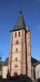 Kirche Notre-Dame
 -
 Schloss Senonches


Persönlichkeiten
- Charles Lafosse, Dichter
- Charles Pitou (1849–1927), Dichter
- Lucien Descaves (1861–1949), Romancier
Städtepartnerschaften
- Battenberg (Eder)
Literatur
- Histoire de Senonches et de ses environs, Paul Alexandre, Amis du Perche, ISBN 2-900122-18-X
Weblinks
Commons: Senonches – Sammlung von Bildern, Videos und Audiodateien
- Site officiel de la ville


