Étrœungt
Commune in Hauts-de-France, France

Coat of arms
Location of Étrœungt

(2020–2026) Vincent Justice[1]
1
(2021)[2]
59218 /59219
Étrœungt (French pronunciation: [e.tʁœ̃]) is a commune in the Nord department in northern France.[3]
Geography
The river Helpe Mineure (one of Sambre's affluents) runs through the village.[4] The river is subject to occasional flooding. Étrœungt is bordered by ten other communes, including two from Aisne department: Avesnelles, Boulogne-sur-Helpe, Féron, Floyon, Haut-Lieu, La Flamengrie (Aisne), Larouillies, Rainsars, Rocquigny (Aisne), Sémeries. The nearest train station is (SNCF) Avesnes-sur-Helpe. It is 110 km from Lille (Préfecture du Nord), Brussels and Reims (Marne); 55 km from Valenciennes, Laon, Mons and Charleroi; 22 km from Maubeuge; 10 km from Fourmies and 7 km from Avesnes-sur-Helpe. Highways leading to Étrœungt are the RN2 from Paris to Brussels. Belgium is just 15 km away.
Heraldry
 | The arms of Étrœungt are blazoned : Quarterly 1&4: Argent, 3 fesses gules; 2&3: Argent, 3 wagoner's axes top 2 addorsed gules. [5](Bermerain, Étrœungt, Féron, Ferrière-la-Grande, Lez-Fontaine, Rousies, Solre-le-Château and Solrinnes use the same arms.)
|
Gallery
-
 Road
Road -

-
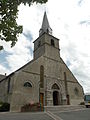 Étrœungt Church
 -
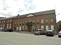 Town Hall
 -
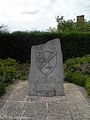 Memorial to the Algerian War Casualties
 -
 Stadium


See also
References
- ^ "Répertoire national des élus: les maires". data.gouv.fr, Plateforme ouverte des données publiques françaises (in French). 2 December 2020.
- ^ "Populations légales 2021". The National Institute of Statistics and Economic Studies. 28 December 2023.
- ^ INSEE commune file
- ^ Sandre. "Fiche cours d'eau - Helpe Mineure (D0130700)".
- ^ Arms of the families of Croÿ-Solre and Croÿ-Renty quartered
Wikimedia Commons has media related to Étrœungt.


