Altenberg bei Linz
You can help expand this article with text translated from the corresponding article in German. (November 2016) Click [show] for important translation instructions.
- View a machine-translated version of the German article.
- Machine translation, like DeepL or Google Translate, is a useful starting point for translations, but translators must revise errors as necessary and confirm that the translation is accurate, rather than simply copy-pasting machine-translated text into the English Wikipedia.
- Do not translate text that appears unreliable or low-quality. If possible, verify the text with references provided in the foreign-language article.
- You must provide copyright attribution in the edit summary accompanying your translation by providing an interlanguage link to the source of your translation. A model attribution edit summary is
Content in this edit is translated from the existing German Wikipedia article at [[:de:Altenberg bei Linz]]; see its history for attribution. - You may also add the template
{{Translated|de|Altenberg bei Linz}}to the talk page. - For more guidance, see Wikipedia:Translation.
Place in Upper Austria, Austria

Coat of arms
(2023)[2]
4203
Altenberg bei Linz is a municipality in the district of Urfahr-Umgebung in the Mühlviertel region in the Austrian state of Upper Austria.
Geography
Located on a southern part of the Zentralmühlviertler Hochland [de] at a altitude of 592 meters, the municipality has a view over the Mühlviertel region, Linz, the capital of Upper Austria aswell as the so-called Zentralland and even the foothills of the Northern Limestone Alps. Because of that, it has been described as the "Balcony of Linz".[3][4]
History
Neolithical finds, show that nomadic hunter-gatherers lived in the region at least temporarily. Celtic Boii and Varisci people settled in the region in pre-Christian times. After conflicts with the Pannonian Avars, slavs are presumed to have moved to region in the 8th century. The Slavic roots of the village name Kulm is a reminder of this. In the 9th century a further wave of bavarian immigrants moved there. In 1245 a document from Passau mentioned a man named "Dominus Karolus de Alkenperge". 3 years later, another document from Passau mentioned the village. This time as "Altenperge".[4]
Cultural heritage sites
As of 2023, there a four cultural heritage sites in Altenberg.[5]
-
![The Gemeindeamt of Altenberg bei Linz [de] at Reichenauer Straße 4, built by Mauriz Balzarek [de] from 1927 to 1930.](//upload.wikimedia.org/wikipedia/commons/thumb/6/6e/Altenberg_%28Gemeindeamt%29.jpg/120px-Altenberg_%28Gemeindeamt%29.jpg) The Gemeindeamt of Altenberg bei Linz [de] at Reichenauer Straße 4, built by Mauriz Balzarek [de] from 1927 to 1930.
The Gemeindeamt of Altenberg bei Linz [de] at Reichenauer Straße 4, built by Mauriz Balzarek [de] from 1927 to 1930. -
![The Late Gothic Catholic church of the Elisabeth of Hungary. It was partially destroyed by lightning strikes and rebuilt in 1742 and 1866.[6] (Schulstraße 1)](//upload.wikimedia.org/wikipedia/commons/thumb/c/c9/Altenberg_%28Pfarrkirche-1%29.jpg/120px-Altenberg_%28Pfarrkirche-1%29.jpg) The Late Gothic Catholic church of the Elisabeth of Hungary. It was partially destroyed by lightning strikes and rebuilt in 1742 and 1866.[6] (Schulstraße 1)
The Late Gothic Catholic church of the Elisabeth of Hungary. It was partially destroyed by lightning strikes and rebuilt in 1742 and 1866.[6] (Schulstraße 1) -
 Work of art on a building's wall (Schulstraße 12)
 -
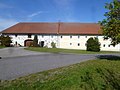 A Farm from the 19th century (Kulm 11)
![The Gemeindeamt of Altenberg bei Linz [de] at Reichenauer Straße 4, built by Mauriz Balzarek [de] from 1927 to 1930.](http://upload.wikimedia.org/wikipedia/commons/thumb/6/6e/Altenberg_%28Gemeindeamt%29.jpg/120px-Altenberg_%28Gemeindeamt%29.jpg)
![The Late Gothic Catholic church of the Elisabeth of Hungary. It was partially destroyed by lightning strikes and rebuilt in 1742 and 1866.[6] (Schulstraße 1)](http://upload.wikimedia.org/wikipedia/commons/thumb/c/c9/Altenberg_%28Pfarrkirche-1%29.jpg/120px-Altenberg_%28Pfarrkirche-1%29.jpg)


Population
| Year | Pop. | ±% |
|---|---|---|
| 1991 | 3,739 | — |
| 2001 | 4,211 | +12.6% |
| 2011 | 4,407 | +4.7% |
| 2018 | 4,553 | +3.3% |
| 2022[7] | 4,696 | +3.1% |
| 2023[2] | 4,740 | +0.9% |
Villages
The municipal area comprises the following 25 villages (followed by their population as of 1 January 2023):
- Altenberg bei Linz (main village): 1.033
- Donach: 244
- Edt: 171
- Haslach: 750
- Katzgraben: 196
- Kitzelsbach: 168
- Kulm: 121
- Niederbairing: 252
- Niederkulm: 10
- Niederwinkl: 230
- Oberbairing: 492
- Oberkulm: 36
- Oberweitrag: 113
- Oberwinkl: 99
- Pargfried: 79
- Preising: 68
- Ramersdorf: 38
- Schwarzendorf: 47
- Stratreith: 194
- Unterweitrag: 127
- Weignersedt: 38
- Wildberg: 2
- Willersdorf: 104
- Windpassing: 87
- Würschendorf: 41
Notable people
- Christina Stürmer (* 1982), Singer and songwriter
- Sonja Horner, winner of the Miss Austria beauty contest in 1996.
References
- ^ "Dauersiedlungsraum der Gemeinden Politischen Bezirke und Bundesländer - Gebietsstand 1.1.2018". Statistics Austria. Retrieved 10 March 2019.
- ^ a b "Bevölkerung am 01.01.2023 nach Ortschaften (Gebietsstand 01.01.2023)". statistik.at.
- ^ "Altenberg bei Linz (593 m)". www.quaeldich.de. Retrieved 2024-01-23.
- ^ a b "Geschichte von Altenberg". Altenberg bei Linz (in Austrian German). Retrieved 2024-01-23.
- ^ "unbewegliche und archäologische Denkmale unter Denkmalschutz" (PDF). Federal Monuments Office. 5 June 2023.
- ^ "Kirche und Religion". Altenberg bei Linz (in Austrian German). Retrieved 2024-01-24.
- ^ "Bevölkerung am 01.01.2022 nach Ortschaften (Gebietsstand 1.1.2022)". statistik.at.
Wikimedia Commons has media related to Altenberg bei Linz.
- v
- t
- e
Municipalities in the district of Urfahr-Umgebung
- Alberndorf in der Riedmark
- Altenberg bei Linz
- Bad Leonfelden
- Eidenberg
- Engerwitzdorf
- Feldkirchen an der Donau
- Gallneukirchen
- Goldwörth
- Gramastetten
- Haibach im Mühlkreis
- Hellmonsödt
- Herzogsdorf
- Kirchschlag bei Linz
- Lichtenberg
- Oberneukirchen
- Ottenschlag im Mühlkreis
- Ottensheim
- Puchenau
- Reichenau im Mühlkreis
- Reichenthal
- Sankt Gotthard im Mühlkreis
- Schenkenfelden
- Sonnberg im Mühlkreis
- Steyregg
- Vorderweißenbach
- Walding
- Zwettl an der Rodl
Authority control databases | |
|---|---|
| International |
|
| National |
|
 | This Upper Austria location article is a stub. You can help Wikipedia by expanding it. |
- v
- t
- e


