Amt Meyenburg
Amt Meyenburg is an Amt ("collective municipality") in the district of Prignitz, in Brandenburg, Germany. Its seat is in Meyenburg.
The Amt Meyenburg consists of the following municipalities:
- Gerdshagen
- Halenbeck-Rohlsdorf
- Kümmernitztal
- Marienfließ
- Meyenburg
Demography
-
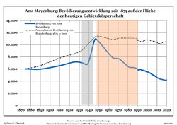 Development of population since 1875 within the current Boundaries (Blue Line: Population; Dotted Line: Comparison to Population development in Brandenburg state; Grey Background: Time of Nazi Germany; Red Background: Time of communist East Germany)
 -
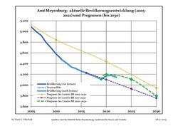 Recent Population Development and Projections (Population Development before Census 2011 (blue line); Recent Population Development according to the Census in Germany in 2011 (blue bordered line); Projection by the Brandenburg state for 2005-2030 (yellow line); Projection by the Brandenburg state for 2017-2030 (velvet line); Projection by the Brandenburg state for 2020-2030 (green line))


|
|
|
References
- ^ Detailed data sources are to be found in the Wikimedia Commons.Population Projection Brandenburg at Wikimedia Commons
- v
- t
- e
 Collective municipalities of Brandenburg in Germany
The Ämter are listed per district (Landkreis)
- Biesenthal-Barnim
- Britz-Chorin-Oderberg
- Joachimsthal (Schorfheide)
- Lieberose/Oberspreewald
- Schenkenländchen
- Unterspreewald
- Elsterland
- Kleine Elster (Niederlausitz)
- Plessa
- Schlieben
- Schradenland
- Liebenwerda (VG)
- Lindow (Mark)
- Neustadt (Dosse)
- Temnitz
- Bad Wilsnack/Weisen
- Lenzen-Elbtalaue
- Meyenburg
- Putlitz-Berge
Authority control databases | |
|---|---|
| International |
|
| National |
|
53°18′50″N 12°14′51″E / 53.313928°N 12.247585°E / 53.313928; 12.247585
 | This Brandenburg location article is a stub. You can help Wikipedia by expanding it. |
- v
- t
- e


