BP Structure
Exposed impact crater in Libya


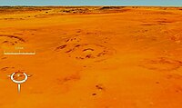
The BP Structure, also known as Gebel Dalma, is an exposed impact crater in Libya. It is so called because it was identified by a BP (then British Petroleum) geological survey team.[1]
The crater is 2 kilometres (1.2 mi) in diameter and its age is estimated to be less than 120 million years (Lower Cretaceous or later).
See also
- Silverpit crater
References
- ^ "BP". Earth Impact Database. Planetary and Space Science Centre University of New Brunswick Fredericton. Retrieved 2009-08-12.
External links
- Anonymous (nd) Africa (Impact Craters), Earth Impact Database, Planetary and Space Science Centre, University of New Brunswick, New Brunswick, Canada.
25°19′10″N 24°18′34″E / 25.31944°N 24.30944°E / 25.31944; 24.30944
- v
- t
- e
- Impact crater
- Impact event


- Acraman
- Amelia Creek
- Araguainha
- Beaverhead
- Boltysh
- Carswell
- Charlevoix
- Chesapeake Bay
- Chicxulub
- Clearwater East and West
- Gosses Bluff
- Haughton
- Kamensk
- Kara
- Karakul
- Keurusselkä
- Lappajärvi
- Logancha
- Manicouagan
- Manson
- Mistastin
- Mjølnir
- Montagnais
- Morokweng
- Nördlinger Ries
- Obolon'
- Popigai
- Presqu'île
- Puchezh-Katunki
- Rochechouart
- Saint Martin
- Shoemaker
- Siljan Ring
- Slate Islands
- Steen River
- Strangways
- Sudbury
- Tookoonooka
- Tunnunik
- Vredefort
- Woodleigh
- Yarrabubba
- Alvarez hypothesis
- Australite
- Breccia
- Coesite
- Complex crater
- Cretaceous–Paleogene boundary
- Cryptoexplosion
- Ejecta blanket
- Impact crater
- Impact structure
- Impactite
- Late Heavy Bombardment
- Lechatelierite
- Meteorite
- Moldavite
- Ordovician meteor event
- Philippinite
- Planar deformation features
- Shatter cone
- Shock metamorphism
- Shocked quartz
- Stishovite
- Suevite
- Tektite
| |
|---|---|
| Divisions |
|
| Subsidiaries | |
| Brands | |
| Facilities | |
| Sponsorships | |
| People | |
| Controversies |
|
| Historical units |
|
| Other | |
| |

 | This geology article is a stub. You can help Wikipedia by expanding it. |
- v
- t
- e
 | This Libya location article is a stub. You can help Wikipedia by expanding it. |
- v
- t
- e


