Brownsville, Vermont
Unincorporated community in Vermont, United States
43°28′07″N 72°28′15″W / 43.46861°N 72.47083°W / 43.46861; -72.4708305037
Brownsville is an unincorporated community in West Windsor, Vermont, United States. Located on Vermont Route 44, the village houses a number of administrative offices for the town of West Windsor.
History
The village derives its name from two settlers, John and Briant Brown. The West Windsor Historical Society is in Brownsville and has a wealth of information on the sheep farms and industries that sustained the early residents.[citation needed]
Just east of Brownsville is the entrance to Ascutney Mountain Resort, which used to be one of the major ski areas in the state, until it closed for good in 2010 and their ski lifts were sold in August 2014. In 2015, Brownsville bought the failed ski area, working with the state of Vermont and the nonprofit Trust for Public Land.[2]
Geography
Slightly south and west of Brownsville is the 656-acre (2.65 km2) Little Ascutney Wildlife Management Area,[3] a state owned conservation area hosting wildlife such as white-tailed deer, fisher, coyotes, bobcats, beaver and otter.
-
 View of town and Mt. Ascutney from the cemetery

Covered Bridges
Three of Vermont's covered bridges are nearby – Best's Bridge near Churchill Road and Bowers Bridge, both of which are listed in the National Register of Historic Places. The Twigg bridge on Yale Road was moved to its location by a developer and was heavily damaged by wind in 2002. The flooding caused by tropical storm Irene in 2011 damaged several bridges such as the Bowers Bridge.[4]
-
 Best's Covered Bridge
 -
 Bowers Covered Bridge
 -
 Construction detail of Bowers Bridge


Government
-
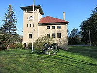 West Windsor Office Building
 -
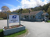 US Post Office on Highway 44


Notes
- ^ a b U.S. Geological Survey Geographic Names Information System: Brownsville, Vermont. Retrieved on 07-04-2019.
- ^ Goodman, David (February 1, 2022). "A Town That Saved a Mountain, and a Mountain That Saved a Town". The New York Times. ISSN 0362-4331. Retrieved February 2, 2022.
- ^ Little Ascutney Wildlife Management Area
- ^ "Irene's silver lining: Vermont rediscovers its bridges". NBC News. October 10, 2011. Retrieved March 28, 2024.
- v
- t
- e
Municipalities and communities of Windsor County, Vermont, United States
Shire town: Woodstock
- Ludlow
- Perkinsville
- Woodstock
- Ascutney
- Bethel
- Cavendish
- Chester
- Hartford Village
- Hartland
- North Hartland
- North Springfield
- Norwich
- Proctorsville
- Quechee
- Rochester
- South Royalton
- South Woodstock
- Springfield
- West Woodstock
- Weston
- White River Junction
- Wilder
- Windsor
communities
- Vermont portal
- United States portal


