Bukit Batu
Bukit Batu | |
|---|---|
Mukim | |
 | |
| Country | Malaysia |
| State | Johor |
| District | Kulai |
| Area | |
| • Total | 86 km2 (33 sq mi) |
| Population | |
| • Total | 15 549 |
Bukit Batu is a mukim (subdivision) in Kulai District, Johor, Malaysia.[1] Bukit Batu means "Hill of Rock" in Malay. Kulai Municipal Council administer the town.
History
The village's legend, about hundred years ago, the tiger Kalimantan conquered and chaos this area, and Chong successfully lead a group of villagers to stop and kill the tiger. During WW2, the Japanese conquered this village; with the help of Chong, the villagers survived and successfully stopped the Japanese coming into the village.
Geography
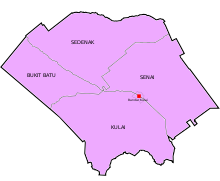
The mukim spans over an area of 86 km2.[2]
Demographics
A mainly Hakka community, the majority of the villagers have the same surname, "Chong". The mukim has 14,147 people.[3]
Economy
Most villagers are oil plantation owners, and most live in bungalows.
Transportation
Road
The town is accessible by bus from Larkin Sentral (2, 888) in Johor Bahru.[4]
References
- v
- t
- e
State of Johor
- Capital city: Johor Bahru
- Administrative capital: Iskandar Puteri
- Royal town: Bandar Maharani (Muar)
| Topics |
|
|---|


divisions
- 10 Districts and 16 Local governments (3 Cites, 7 Municipals, 6 Districts)
- Special zone: (Iskandar Malaysia, RAPID Pengerang)
(Majlis Bandaraya)
| Johor Bahru (part of Johor Bahru district) | |
|---|---|
| Iskandar Puteri (part of Johor Bahru district) | |
| Pasir Gudang (part of Johor Bahru district) |
(Majlis Perbandaran)
| Muar (Muar district) | |
|---|---|
| Batu Pahat (Batu Pahat district) | |
| Kluang (Kluang district) | |
| Kulai (Kulai district) | |
| Segamat (Segamat district) | |
| Pengerang (Kota Tinggi district) | |
| Pontian |
(Majlis Daerah)
| Kota Tinggi | |
|---|---|
| Mersing | |
| Tangkak | |
| Labis (Segamat district) | |
| Yong Peng (Batu Pahat district) | |
| Simpang Renggam (Kluang district) |
 Commons
 Wikisource
 Category

1°43′N 103°26′E / 1.717°N 103.433°E / 1.717; 103.433


