Cardinia, Victoria
Town in Victoria, Australia
| Cardinia Victoria | |
|---|---|
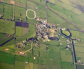 Aerial photo from the south-west | |
 | |
| Population | 342 (2021 census)[1] |
| Postcode(s) | 3978 |
| Elevation | 55 m (180 ft) |
| Location |
|
| LGA(s) | Shire of Cardinia |
| State electorate(s) | Bass |
| Federal division(s) |
|
Cardinia is a town in Victoria, Australia, 52 km south-east of Melbourne's Central Business District, located within the Shire of Cardinia local government area. Cardinia recorded a population of 342 at the 2021 census.[1]
Cardinia is located between Pakenham and Tooradin on the south-eastern fringe of Melbourne.
The Post Office opened on 1 September 1881, was known as Cardinia Creek until 1912, and closed in 1970.[2]
Cardinia is part of the Australian Rules ROC Football Club (Rythdale, Officer, Cardinia) competing in the Mornington Peninsula Nepean Football League.
See also
- City of Cranbourne – Cardinia was previously within this former local government area.
References
- ^ a b Australian Bureau of Statistics (28 June 2022). "Cardinia (Suburbs and Localities)". 2021 Census QuickStats. Retrieved 9 July 2022.

- ^ Premier Postal History, Post Office List, retrieved 11 April 2008
38°08′49″S 145°25′23″E / 38.147°S 145.423°E / -38.147; 145.423
- v
- t
- e
Localities in the Shire of Cardinia

- Avonsleigh
- Bayles
- Beaconsfield^
- Beaconsfield Upper
- Bunyip
- Cardinia
- Catani
- Clematis
- Cockatoo
- Cora Lynn
- Emerald^
- Garfield
- Garfield North
- Gembrook
- Guys Hill
- Iona
- Koo Wee Rup
- Lang Lang^
- Longwarry^
- Maryknoll
- Menzies Creek^
- Nar Nar Goon
- Nar Nar Goon North
- Nyora^
- Officer South
- Pakenham South
- Pakenham Upper
- Tonimbuk
- Tooradin^
- Tynong
- Tynong North
- Yannathan
^ - Territory divided with another LGA
 | This article about a location in Victoria, Australia is a stub. You can help Wikipedia by expanding it. |
- v
- t
- e


