Chake Chake District
District of Pemba South Region, Tanzania
District in Pemba South Region, Tanzania
Chake Chake | |
|---|---|
District | |
  From top to bottom: Dhows on the western shore of the district & Small office building in Chake-Chake town | |
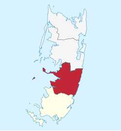 Location in Pemba South | |
| Coordinates: 5°14′42.72″S 39°47′46.32″E / 5.2452000°S 39.7962000°E / -5.2452000; 39.7962000 | |
| Country |  Tanzania Tanzania |
| Region | Pemba South Region |
| Named for | Town of Chake-Chake |
| Capital | Chake-Chake |
| Area | |
| • Total | 219 km2 (85 sq mi) |
| • Rank | 2nd in Pemba South |
| Population (2022) | |
| • Total | 136,298 |
| • Rank | 2nd in Pemba South |
| • Density | 620/km2 (1,600/sq mi) |
| Demonym | Chakechaken |
| Ethnic groups | |
| • Settler | Swahili |
| • Native | Hadimu |
Chake Chake District (Swahili: Wilaya ya Chake Chake) is one of two administrative districts of Pemba South Region in Tanzania.[1] The district covers an area of 219 km2 (85 sq mi).[2] The district is comparable in size to the land area of American Samoa.[3] The district has a water border to the east and west by the Indian Ocean. The district is bordered to the south by Mkoani District and the north by Wete District of Pemba North Region. The district seat (capital) is the town of Chake-Chake. According to the 2022 census, the district has a total population of 136,298.[4]
Administrative subdivisions
As of 2012, Chake Chake District was administratively divided into 31 wards.[5]
Wards
|
|
|
References
- ^ "Chake Chake District".
- ^ "Chake Chake District Profile" (PDF). Government of Zanzibar. 2019. Archived from the original (PDF) on 19 June 2022. Retrieved 23 July 2022.
- ^ 199 km2 (77 sq mi) for Cook Islands at "Area size comparison". Nation master. 2022. Retrieved 23 July 2022.
- ^ "2012 Population and Housing Census General Report" (PDF). Government of Tanzania. Archived from the original (PDF) on 2022-03-26. Retrieved 2022-06-10.
- ^ "Chake Chake District".
- v
- t
- e
Chake Chake District
Capital: Chake-Chake
- Chachani
- Chanjaani
- Chonga
- Dodo
- Kibokoni
- Kichungwani
- Kilindi
- Kwale
- Madungu
- Matale
- Mbuzini
- Mfikiwa
- Mgelema
- Mgogoni
- Michungwani
- Mkoroshoni
- Msingini
- Mvumoni
- Ndagoni
- Ng'ambwa
- Pujini
- Shungi
- Tibirinzi
- Uwandani
- Vitongoji
- Wara
- Wawi
- Wesha
- Ziwani
- Lake Mkomani
- Changedi River
- Gombani
- Vitongoji
 | This Pemba South Region location article is a stub. You can help Wikipedia by expanding it. |
- v
- t
- e


