Cote, West Sussex
Human settlement in England
- Worthing
- West Sussex
- South East
- Worthing West
- List of places
- UK
- England
- West Sussex
Cote (also Walcote[1] or Coate[2]) was a hamlet in the former parish of Durrington, West Sussex (now a suburb of Worthing), England.[1] It is 3 miles (4.8 km) northwest of Worthing.[2] The old Chichester–Brighton Roman road ran tangentially to the south of the hamlet.[1] "Cote" comes from the Old English word for a dwelling or home (not strictly a cottage), and is widespread in place names in Sussex.[3][4][5] There is an area of public amenity land at Cote Bottom, known as the Bird Sanctuary and owned by Worthing Council since 1941.
Early history
It is recorded in c. 1266 as the 2-acre (0.81 ha) home of William de la Cote, son of Thomas de la Walcote, in the then parish of Clopham (now Clapham) and next to the land of Andrew la Holte, son of John la Holte; in a deed when it was bought from him by brothers William and John Clerk, who were to pay an annual rent of 3 pennies at Michaelmas.[4][6] As of the 20th century, neighbouring Holt Farm still lay across the parish boundary in Clapham parish.[7]
It has been recorded from the 12th century through to 1841, and still had some pre-20th-century houses as of 1978.[1] Originally it, like Durrington, was entirely surrounded by open fields.[8]
Thomas Yeakell's and William Gardner's Map of Sussex shows 6 houses in 1795, and the census recorded 62 inhabitants in 1841.[1] Until sometime in the middle of the 19th century, it was copyhold or freehold of Broadwater Manor.[9] In the early 19th century it was in the hundred of Tarring,[10] combined with Durrington into a 641-acre (259 ha) Durrington and Coate, and alongside Salvington, Heene, and a small 20-acre (8.1 ha) area of downland next to Findon named "No Man's Land".[11] Two of the four large farms in the parish, one of 131 acres (53 ha) and one of 211 acres (85 ha), were in Cote c. 1839,[8] when there was also a parish house for parish meetings.[12]
Cote Bottom and Munery's Copse
Geological site
The adjacent Cote Bottom is a local geological site in Worthing District.[13][14] Christopher T. A. Gaster recorded the discovery of Bicavea radiata in his pit number 17 there.[15][nb 1] That pit is also the location of a flint seam named Cotes Bottom Flint, described by geologist Rory N. Mortimore as a "double seam of large nodular masses with occasional columnar or paramoudra flint.".[17] The adjacent Munery's Copse is the location of Gaster's pit 18, to the west of pit 17.[18]
In October 1951, Cote Street and Cote Bottom Farm were described as part of Durrington, "on the north side of the main Worthing-Arundel Road, close to Swandean Hospital", when the farm was sold along with 400 turkeys, poultry houses and various farm equipment.[19] In 1954, Worthing Council was looking for a site for a new crematorium,[20] and chose Munery's Copse. However, in 1960 the council was refused planning permission for it.[21]
Bird Sanctuary
In 1939, Worthing Corporation pledged "that [Cote Bottom] be kept as a public open space for all time and let it be known as the sanctuary, having been paid for" by public subscription.[22] This move also prevented development on the land.[23] In 1941, the land, as part of the South Downs, was transferred to Worthing Corporation and designated as a public amenity, after local people had "done so much" to secure the land "for public walks and pleasure grounds",[24] and as an "open space for the people of Worthing for all time". However, in April 1952 the council had to deal with an angry deputation after it offered half of the land for agricultural use.[25][26][27] By May 1952, Cote Bottom was supporting wildlife, which in turn was attracting interest, and reporting on it was Dr A. H. Murch,[nb 2] "whose bird life films [were] well known". Among the wildlife reported there on 13 April were nightingale, lapwing and pipistrelle bat.[28] In 1952, Cote Bottom was described in the Worthing Herald as a district of High Salvington, when seventeen acres of land were offered for hay-cutting.[29]
Worthing Council still owns the abovementioned land at Honeysuckle Lane, Cote Bottom, Worthing, known as the Bird Sanctuary.[30] The Bird Sanctuary is now protected as a Site of Nature Conservation Importance (SNCI) and as part of South Downs National Park. It is a "chalk grassland, scrub and semi-natural woodland" area adjacent to High Salvington. Its listing says, "The site represents a scarce habitat in the Borough. Meadow Clary Salvia pratensis, a Red Data Book species, occurs here in one of only two sites in West Sussex ... The combination of grassland and scrub is important for birds and invertebrates".[31]
-
![1952 cartoon referencing the dispute (Worthing Herald)[32]](//upload.wikimedia.org/wikipedia/commons/thumb/a/ad/Cartoon_-_Worthing_Herald_-_4_April_1952.JPG/308px-Cartoon_-_Worthing_Herald_-_4_April_1952.JPG) 1952 cartoon referencing the dispute (Worthing Herald)[32]
1952 cartoon referencing the dispute (Worthing Herald)[32] -
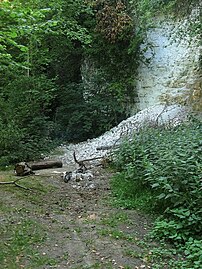 The chalk pit in Cote Bottom
 -
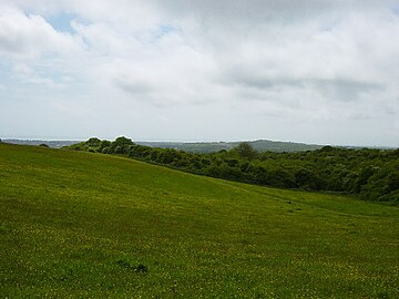 Uncultivated land in the Cote Bottom area
![1952 cartoon referencing the dispute (Worthing Herald)[32]](http://upload.wikimedia.org/wikipedia/commons/thumb/a/ad/Cartoon_-_Worthing_Herald_-_4_April_1952.JPG/308px-Cartoon_-_Worthing_Herald_-_4_April_1952.JPG)


Upper Cote
In 1948, Upper Cote was mentioned in the Worthing Herald newspaper, confirming that the village name existed at that time.[33]
Notes
- ^ Christopher T. A. Gaster (1878–1963), a Fellow of the Geological Society from Hove,[16] who published several important papers on the Chalk of southern England.
- ^ Dr A. H. Murch was a Worthing resident, and a member of Sussex Ornithological Society. See: The Sussex Bird Report, 1953
References
- ^ a b c d e Baggs et al. 1980a, p. 82.
- ^ a b Wilson 1866, p. 462.
- ^ Hare 1894, p. xiv.
- ^ a b Mawer, Stenton & Gover 1929, p. 196.
- ^ Roberts 1914, p. 49.
- ^ Godman 1896, p. 99.
- ^ Baggs et al. 1980b, p. 10.
- ^ a b Baggs et al. 1980a, p. 83.
- ^ Fenton 1892, p. 158.
- ^ Cartwright 1830, p. 1.
- ^ Lower 1870, p. 195.
- ^ Baggs et al. 1980a, p. 84.
- ^ WLP 2018, p. 23.
- ^ "Cote Bottom, High Salvington". geodiversitysussex.org.uk. Geodiversity Sussex. Archived from the original on 15 November 2023. Retrieved 15 November 2023.
Click on "Cote Bottom" in the box, to see the map of the site
- ^ Gaster 1932, pp. 221–222.
- ^ RGS 1930, p. 27.
- ^ Mortimore 1986, p. 131.
- ^ Larwood 1962, p. 194.
- ^ WH 1951.
- ^ "Cemeteries will be full in five years. Government help to be sought". Worthing Gazette. 2 June 1954. p. 4 cols 7,8. Retrieved 28 November 2023 – via British Newspaper Archive.
- ^ "Crematorium: minister's decision deplored". Worthing Gazette. 13 January 1960. p. 5 col.6. Retrieved 28 November 2023 – via British Newspaper Archive.
- ^ WH 1952a.
- ^ WH 1938.
- ^ WH 1952b.
- ^ WH 1952d.
- ^ WH 1952c.
- ^ WH 1952e.
- ^ WH 1952f.
- ^ WH 1952g.
- ^ "Search for land and property information: Title number WSX292325". gov.uk. The Land Registry (H.M. Government). Archived from the original on 25 November 2023. Retrieved 25 November 2023.
- ^ Hankinson Duckett Associates. "The Sanctuary, High Salvington" (PDF). adur-worthing.gov.uk. Worthing Borough Council. p. 51. Archived (PDF) from the original on 16 November 2023. Retrieved 16 November 2023.
- ^ WH 1952h.
- ^ WH 1948.
Sources
- Baggs, A. P.; Currie, C. R. J.; Elrington, C. R.; Keeling, S. M.; Rowland, A. M. (1980a). "Durrington". In Hudson, T. P. (ed.). A History of the County of Sussex. Vol. 6 Bramber Rape (Southern Part). London: British History Online. pp. 81–85. Archived from the original on 29 October 2023. Retrieved 13 November 2023.
- Baggs, A. P.; Currie, C. R. J.; Elrington, C. R.; Keeling, S. M.; Rowland, A. M. (1980b). "Clapham". In Hudson, T. P. (ed.). A History of the County of Sussex. Vol. 6 Bramber Rape (Southern Part). London: British History Online. pp. 10–21. Archived from the original on 4 December 2023. Retrieved 14 November 2023.
- Wilson, John Marius (1866). "Coate". The Imperial Gazetteer of England and Wales. Vol. 1.
- Fenton, Alexander James (1892). "Some extracts related to Sussex". Sussex Archaeological Collections Relating to the History and Antiquities of the County. Vol. 38. Sussex Archaeological Society. pp. 141–159.
- Cartwright, Edmund (1830). The Parochial Topography of the Rape of Bramber, in the Western Division of the County of Sussex. Vol. 2. London: J. R. Nichols.
- Lower, Mark Antony (1870). A Compendious History of Sussex. Vol. 2. Lewes: George P. Bacon.
- Mawer, Allen; Stenton, Frank Merry; Gover, John Eric Bruce (1929). The Place-names of Sussex. Vol. 6. Cambridge: The University Press.
- Godman, Percy S. (1896). "Itchingfield". Sussex Archaeological Collections Relating to the History and Antiquities of the County. Vol. 40. Sussex Archaeological Society. pp. 79–130.
- Gaster, Christopher T. A. (3 June 1932). The Zones of Chalk of the Arun Gap, Sussex: With description of new species of Bicavea. Weald Research Committee Reports. pp. 212–223. doi:10.1016/S0016-7878(32)80017-9. Archived from the original on 13 November 2023. Retrieved 13 November 2023.
- Mortimore, Rory N. (1986). "Stratigraphy of the upper cretaceous white chalk of Sussex". Proceedings of the Geologists' Association. 97 (2): 97–139. Bibcode:1986PrGA...97...97M. doi:10.1016/S0016-7878(86)80065-7. Archived from the original on 15 November 2023. Retrieved 13 November 2023.
- Larwood, Gilbert Powell (1962). "The morphology and systematics of some Cretaceous Cribrimorph Polyzoa (Pelmatoporinae)". Bulletin of the British Museum (Natural History) Geology. 6 (1). London: Trustees of the British Museum: 1–285. ark:/13960/t81k3br5q. (The morphology and systematics of some Cretaceous Cribrimorph Polyzoa (Pelmatoporinae) at the Internet Archive)
- Hare, Augustus John Cuthbert (1894). Sussex. London: George Allen.
- Roberts, R. G. (1914). The Place-Names of Sussex. Cambridge: The University Press.
- Worthing Local Plan (PDF), Worthing Borough Council, August 2018, 70033198, archived (PDF) from the original on 6 October 2022, retrieved 14 November 2023
- "List of Fellows". List of the Geological Society of London. Geological Society of London. 1930. pp. 11 et seq.
- "Cote Bottom meeting approves a protest". Worthing Herald. 11 April 1952. p. 5 col. 2,3. Retrieved 14 November 2023 – via British Newspaper Archive.
- "Chickens and Cattle at Cote Bottom. Council is accused of breaking faith". Worthing Herald. 7 March 1952. p. 9, cols 1–3. Retrieved 14 November 2023 – via British Newspaper Archive.
- "Cote Bottom: Nancy Price calls for a protest meeting". Worthing Herald. 14 March 1952. p. 7 cols 1,2. Retrieved 14 November 2023 – via British Newspaper Archive.
- "Committee wants to please everyone. Cote Bottom: deputation invited". Worthing Herald. 4 April 1952. p. 1 col.1, and 5 col.4. Retrieved 14 November 2023 – via British Newspaper Archive.
- "Chickens may return to Cote Bottom". Worthing Herald. 22 February 1952. p. 7 cols 3,4. Retrieved 14 November 2023 – via British Newspaper Archive.
- "Cote Bottom dawn chorus". Worthing Herald. 16 May 1952. p. 9 col.4. Retrieved 14 November 2023 – via British Newspaper Archive.
- "Borough of Worthing: land, Cote Bottom". Worthing Herald. 9 May 1952. p. 2, col.2. Retrieved 14 November 2023 – via British Newspaper Archive.
- "You chickens". Worthing Herald. 4 April 1952. p. 7 cols 2,3. Retrieved 14 November 2023 – via British Newspaper Archive.
- "Cote Bottom Farm, Cote Street, Durrington, Worthing". Worthing Herald. 12 October 1951. p. 19 col.4. Retrieved 14 November 2023 – via British Newspaper Archive.
- ""Dogs tore chicken to pieces", court told". Worthing Herald. 19 November 1948. p. 16 col.1. Retrieved 14 November 2023 – via British Newspaper Archive.
- "High Salvington land to be saved ... Owner refused permission to develop". Worthing Herald. 8 April 1938. pp. 27, 1, 2. Retrieved 14 November 2023 – via British Newspaper Archive.
Further reading
- Gaster, Christopher T. A. (1924). "The Chalk of the Worthing District, Sussex". Proceedings of the Geologists' Association. 35 (2): 89–110. Bibcode:1924PrGA...35...89G. doi:10.1016/S0016-7878(24)80019-6.
- Gale, Andrew Scott (2017). "An integrated microcrinoid zonation for the lower Campanian chalks of southern England, and its implications for correlation". Cretaceous Research. 87: 312–357. doi:10.1016/j.cretres.2017.02.002. S2CID 132123752. Archived from the original on 13 November 2023. Retrieved 13 November 2023.
External links
![]() Media related to Cote, Worthing at Wikimedia Commons
Media related to Cote, Worthing at Wikimedia Commons
- "Yeakell and Gardner's Sussex 1778–1783, 2inch to 1 mile". Old Sussex Mapped. The Department of Geography, University of Portsmouth.
- British Geological Survey. "Cotes Bottom Flint". UK Research and Innovation. CBFL.
- Cote, Worthing, in Google StreetView. Follow Cote Street, going north from the A27: it is a street settlement.
- v
- t
- e
- Council
- Local elections
- Constituencies
- East Worthing and Shoreham
- Worthing West
- MPs
- Tim Loughton
- Peter Bottomley
- Transport in Worthing
- Railway stations
- East Worthing
- Worthing
- West Worthing
- Durrington-on-Sea
- Goring-by-Sea
- Roads
- A24
- A27
- A259
- Stagecoach South
- Compass Bus
- Worthing Tramocars
- Schools in Worthing
- Current
- Worthing College
- Northbrook College
- Davison High School
- Durrington High School
- St Andrew's High School
- St Oscar Romero Catholic School
- Worthing High School
- Bohunt School Worthing
- Former
- St Ronan's School
- Sports clubs
- Worthing F.C.
- Worthing F.C. Women
- Worthing United F.C.
- Worthing C.C.
- Worthing R.F.C.
- Worthing Thunder
- Worthing Golf Club
- Sports events
- International Birdman (Defunct)
- Sports venues
- Beach House Park
- Leisure Centre
- Manor Sports Ground
- Splashpoint Leisure Centre
- Culture
- Connaught Theatre
- End of the Pier Film Festival
- Museum and Art Gallery
- Worthing Symphony Orchestra
- Nature locations
- Cissbury Ring
- Ferring Rife
- Highdown Gardens
- Teville Stream
- Titnore Wood
- Worthing Downland Estate
- Streets
- High Street, Worthing
and districts


