Den Dungen
Village in North Brabant, Netherlands

Flag
Coat of arms
51°39′55″N 5°22′17″E / 51.66528°N 5.37139°E / 51.66528; 5.37139
(2021)[1]
5275[1]
Den Dungen is a village in the Dutch province of North Brabant. It is located in the municipality of Sint-Michielsgestel next to the village Maaskantje.
History
The village was first mentioned in 1300 as "Super Donghen prope Buscum", and means "sandy hills in swampy land".[3] Den Dungen developed in the Middle Ages on three hills near the Aa River. During the 17th century, a ring dike was built to protect against floods.[4]
The Catholic St.-Jacobus de Meerdere Church was completed in 1533. In 1899, a new tower was constructed with a needle spire. In 1927, the church was expanded.[4]
Den Dungen was home to 1,399 people in 1840.[5] Around 1900, Den Dungen and Maaskantje started to merge into a single urban area.[4] It was a separate municipality until 1996, when it was merged with Sint-Michielsgestel.[6]
Den Dungen is a twin town of Portishead, Somerset in England.
Gallery
-
 Church in Den Dungen
 -
 Bicycle bridge
 -
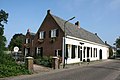 Farm in Den Dungen
 -
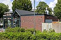 Snackbar in Den Dungen


References
- ^ a b c "Kerncijfers wijken en buurten 2021". Central Bureau of Statistics. Retrieved 18 April 2022.
- ^ "Postcodetool for 5275AA". Actueel Hoogtebestand Nederland (in Dutch). Het Waterschapshuis. Retrieved 18 April 2022.
- ^ "Den Dungen - (geografische naam)". Etymologiebank (in Dutch). Retrieved 18 April 2022.
- ^ a b c Chris Kolman & Ronald Stenvert (1997). Den Dungen (in Dutch). Zwolle: Waanders. ISBN 90 400 9945 6. Retrieved 16 April 2022.
- ^ "Den Dungen". Plaatsengids (in Dutch). Retrieved 18 April 2022.
- ^ Ad van der Meer and Onno Boonstra, Repertorium van Nederlandse gemeenten, KNAW, 2011.
- v
- t
- e
Populated places in the municipality of Sint-Michielsgestel
- Berlicum
- Den Dungen
- Gemonde [nl]
- Maaskantje
- Middelrode [nl]
Authority control databases | |
|---|---|
| International |
|
| National |
|
 | This North Brabant location article is a stub. You can help Wikipedia by expanding it. |
- v
- t
- e


