Fort Ripley Shoal Light
Lighthouse in South Carolina, US
Lighthouse
32°45′58″N 79°54′07″W / 32.766°N 79.902°W / 32.766; -79.902 (approx.)The Fort Ripley Shoal Light or Middle Ground Light was a lighthouse in the Charleston, South Carolina harbor approaches.
History
The channels approaching Charleston fork shortly after passing Fort Sumter, split by a large shoal extending southeast from Shutes' Folly Island. The southern portion, known as the Middle Ground, was the site of the Civil War-era Fort Ripley, cobbled together on an artificial island. The fort has since slumped beneath the waves; it is now evidenced by nothing more than a daymark and notation of submerged rocks on nautical charts.
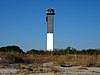
In 1878 a screw-pile lighthouse was erected a short distance from the remains of the fort, to mark the shoal. Little is recorded of its history, and it was deactivated and dismantled in 1932. However, a much larger skeleton tower was erected on the same site to replace the old rear light of the Fort Sumter Range. This tower remains in service, though it's unnamed on charts. It displays three lights: a pair at 166 and 170 feet (51 and 52 m) feet to present the day and night aspects of the range, and a third at 50 feet (15 m), to guide passing ships.
References
Citations
Bibliography
- "Historic Light Station Information and Photography: South Carolina". United States Coast Guard Historian's Office. Archived from the original on 2017-05-01. Retrieved 2008-06-11.
- Chart 11524: Charleston Harbor (Map). 1:20,000. NOAA. 2008-04-19. Retrieved 2008-06-11.
- Neuffer, Claude Henry, ed. (1967). Names in South Carolina: Volumes I-XII, 1954-1965. University of South Carolina. p. 109. Retrieved 2008-06-11.[permanent dead link]
- Light List, Volume III, Atlantic Coast, Little River, South Carolina to Econfina River, Florida (PDF). Light List. United States Coast Guard. 2007. p. 27. ID COMDTPUB P16502.3
- v
- t
- e
Lighthouses of South Carolina
- Bloody Point Range Lights
- Bulls Bay Light
- Castle Pinckney Light
- Cape Romain Lighthouses
- Charleston Light
- Combahee Bank Light
- Fort Ripley Shoal Light
- Fort Sumter Range Lights
- Georgetown Light
- Haig Point Range Lights
- Harbour Town Light
- Hilton Head Range Rear Light
- Hunting Island Lighthouse
- Morris Island Light
- Parris Island Range Lights
- Sullivan's Island Range Lights
| Authority control databases: Geographic |
|
|---|


