Gárdony
Town in Fejér, Hungary

Flag

Coat of arms
 Hungary
 (2017)
2483
Gárdony is a town in Fejér county, Hungary. It is located 55 km (34 miles) from Budapest, the capital of Hungary.
Etymology
The name Gárdony is believed to have originated in the early 13th century.[according to whom?]
History
There is at least one known writing dating back to 1260 that referred to Gardun, King of Zsigmond (1387-1437).
On 31 March 1989 Gárdony changed its status from village to town.
Geography
This town is next to Lake Velencei and is a popular summer destination. The town is divided into three parts: Gárdony, Agárd and Dinnyés and lies on the south shore of the lake.
In the summertime thousands of tourists visit the lake. In fact, several new resorts have recently opened on the shore of the lake. The lake is known as a great destination to bring the family. Tourists, who like water sports such as boating, swimming, sailing and fishing enjoy the lake. On the shore, there are facilities for volleyball, basketball, tennis, and football. Additionally, there is live entertainment planned throughout the summer months.
Notable people
Géza Gárdonyi was born in Gárdony. He was born in Agárdpuszta and a statue of him is located centre park of Agárd.
Twin towns – sister cities
 Gieboldehausen, Germany
 Kirchbach, Austria
 Lesquin, France
- Mörlenbach, Germany
- Postbauer-Heng, Germany
 Salo, Finland
 Valea Crișului, Romania
 Żary, Poland


Sport
The association football club, Gárdonyi VSC, is based in the town.
Gallery
-
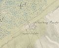 The map of Gárdony from the First Military Mapping Survey of Austria Empire.
 -
 The map of Gárdony from the Second Military Mapping Survey of Austria Empire.
 -
 The map of Gárdony from the 3rd Military Mapping Survey of Austria Empire.
 -
 Second World War Memorial
 -
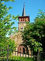 Sacred Heart Church
 -
 Statue of Géza Gárdonyi


See also
External links
Wikinews has related news:
- Hungary: €2.52 million road renovation costs only €1.75 million if it's not financed by the EU
Wikimedia Commons has media related to Gárdony.
- Official website in Hungarian
- Gárdony.lap.hu - Link directory – Startlap (in Hungarian)
- Gárdony at funiq.hu (in English)
- https://www.telepules.com/en/gardony/tourism.html Archived 2019-11-06 at the Wayback Machine?
References

| ||
|---|---|---|
| Cities with county rights |
|   |
| Towns | ||
| Large villages | ||
| Villages |
| |
| Other topics |
| |
Authority control databases | |
|---|---|
| International |
|
| National |
|
| Geographic |
|
 | This Fejér location article is a stub. You can help Wikipedia by expanding it. |
- v
- t
- e


