Geryville, Pennsylvania
Village in Pennsylvania, U.S.

Geryville is a village located mainly in Milford Township, Bucks County but also in Upper Hanover Township, Pennsylvania, United States. The first letter of the name is pronounced as a hard "g." It is located just north of Route 663 and is split between the East Greenville zip code of 18041 and the Pennsburg zip code of 18073.[1] Originally known as Aurora, the village received its name from the postmaster Jesse Gery in 1865. The Publick House on the corner of Sleepy Hollow Road and Geryville Pike played a prominent role in Fries's Rebellion of 1799.[2] It is drained via the Macoby Creek southward into the Perkiomen Creek and Schuylkill River.
Gallery
-
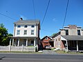
 Jamison Publick House, front
 -
 Geryville Pike in Geryville
 -
 St Lukes Hospital
 -
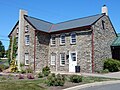 St Lukes Hospital, west wing


References
External links
 Media related to Geryville, Pennsylvania at Wikimedia Commons
- Jamison Publick House Jamison Publick House – Restaurant - Pennsburg, PA
Places adjacent to Geryville, Pennsylvania | ||||||||||||||||
|---|---|---|---|---|---|---|---|---|---|---|---|---|---|---|---|---|
| ||||||||||||||||


- v
- t
- e
Municipalities and communities of Bucks County, Pennsylvania, United States
County seat: Doylestown
- Bristol
- Chalfont
- Doylestown
- Dublin
- Hulmeville
- Ivyland
- Langhorne
- Langhorne Manor
- Morrisville
- New Britain
- New Hope
- Newtown
- Penndel
- Perkasie
- Quakertown
- Richlandtown
- Riegelsville
- Sellersville
- Silverdale
- Telford‡
- Trumbauersville
- Tullytown
- Yardley

- Bedminster
- Bensalem
- Bridgeton
- Bristol
- Buckingham
- Doylestown
- Durham
- East Rockhill
- Falls
- Haycock
- Hilltown
- Lower Makefield
- Lower Southampton
- Middletown
- Milford
- New Britain
- Newtown
- Nockamixon
- Northampton
- Plumstead
- Richland
- Solebury
- Springfield
- Tinicum
- Upper Makefield
- Upper Southampton
- Warminster
- Warrington
- Warwick
- West Rockhill
- Wrightstown
communities
- Almont
- Amity
- Andalusia
- Applebachsville
- Aquetong
- Argus
- Bedminster
- Brick Tavern
- Blooming Glen
- Buckingham
- Bucksville
- Carversville
- Centre Bridge
- Danboro
- Dolington
- Durham
- Elephant
- Erwinna
- Eureka‡
- Fallsington
- Ferndale
- Finland
- Forest Grove
- Fountainville
- Furlong
- Gallows Hill
- Gardenville
- Geryville‡
- Hagersville
- Harrow
- Hartsville
- Highton
- Hilltown
- Hinkletown
- Holicong
- Holland
- Hood
- Jamison
- Kintnersville
- Kulps Corner
- Lahaska
- Line Lexington‡
- Lodi
- Loux Corner (Hilltown)
- Lumberville
- Maple Beach
- Mechanicsville
- Mount Pleasant
- Neshaminy
- Neshaminy Falls
- Newville
- Ottsville
- Oxford Valley
- Penns Park
- Pineville
- Pipersville
- Pleasant Valley
- Point Pleasant
- Revere
- Rushland
- Shelly
- Solebury
- Southampton
- Springtown
- Uhlerstown
- Unionville‡
- Upper Black Eddy
- Washington Crossing
- White Horse
- Wrightstown
- Wycombe
- Zionhill
‡This populated place also has portions in an adjacent county or counties
- Pennsylvania portal
- United States portal

40°24′55″N 75°28′31″W / 40.41528°N 75.47528°W / 40.41528; -75.47528
 | This Bucks County, Pennsylvania state location article is a stub. You can help Wikipedia by expanding it. |
- v
- t
- e
| This Montgomery County, Pennsylvania state location article is a stub. You can help Wikipedia by expanding it. |
- v
- t
- e


