Gonnesa
Comune in Sardinia, Italy

Coat of arms
Location of Gonnesa

39°16′N 8°28′E / 39.267°N 8.467°E / 39.267; 8.467
09010
Gonnesa is a comune (municipality) in the Province of South Sardinia in the Italian region Sardinia, located about 60 kilometres (37 mi) west of Cagliari and about 14 kilometres (9 mi) northwest of Carbonia, in the Iglesiente subregion.
The town was refounded in the late 18th century by the local feudatory. During the 19th century its territory was affected by the resumption of mining which contributed significantly to its population growth .
In the Municipality of Gonnesa is located the mine of Nuraxi Figus, the last active coal mine in Italy today.
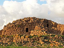
In its territory there is an important archaeological site, the nuraghe Seruci, and beach of almost 4 kilometres (2 mi) along which it is possible to surf, especially in a spot called Funtanamare. The other two spots are called Plag' 'e Mesu ("Middle Beach" in Sardinian language, and Porto Paglia. Gonnesa borders the following municipalities: Carbonia, Iglesias, Portoscuso.
References
External links
Wikimedia Commons has media related to Gonnesa.
- pictures of Gonnesa
- v
- t
- e
- Arbus
- Armungia
- Ballao
- Barrali
- Barumini
- Buggerru
- Burcei
- Calasetta
- Carbonia
- Carloforte
- Castiadas
- Collinas
- Decimoputzu
- Dolianova
- Domus de Maria
- Domusnovas
- Donori
- Escalaplano
- Escolca
- Esterzili
- Fluminimaggiore
- Furtei
- Genoni
- Genuri
- Gergei
- Gesico
- Gesturi
- Giba
- Goni
- Gonnesa
- Gonnosfanadiga
- Guamaggiore
- Guasila
- Guspini
- Iglesias
- Isili
- Las Plassas
- Lunamatrona
- Mandas
- Masainas
- Monastir
- Muravera
- Musei
- Narcao
- Nuragus
- Nurallao
- Nuraminis
- Nurri
- Nuxis
- Orroli
- Ortacesus
- Pabillonis
- Pauli Arbarei
- Perdaxius
- Pimentel
- Piscinas
- Portoscuso
- Sadali, Sardinia
- Samassi
- Samatzai
- San Basilio
- San Gavino Monreale
- San Giovanni Suergiu
- San Nicolò Gerrei
- San Sperate
- San Vito
- Sanluri
- Santadi
- Sant'Andrea Frius
- Sant'Anna Arresi
- Sant'Antioco
- Sardara
- Segariu
- Selegas
- Senorbì
- Serdiana
- Serramanna
- Serrenti
- Serri
- Setzu
- Seui
- Seulo
- Siddi
- Siliqua
- Silius
- Siurgus Donigala
- Soleminis
- Suelli
- Teulada
- Tratalias
- Tuili
- Turri
- Ussana
- Ussaramanna
- Vallermosa
- Villacidro
- Villamar
- Villamassargia
- Villanova Tulo
- Villanovaforru
- Villanovafranca
- Villaperuccio
- Villaputzu
- Villasalto
- Villasimius
- Villasor
- Villaspeciosa
Authority control databases | |
|---|---|
| International |
|
| National |
|
 | This Sardinia location article is a stub. You can help Wikipedia by expanding it. |
- v
- t
- e


