Grgeteg
You can help expand this article with text translated from the corresponding article in French. (March 2018) Click [show] for important translation instructions.
- View a machine-translated version of the French article.
- Machine translation, like DeepL or Google Translate, is a useful starting point for translations, but translators must revise errors as necessary and confirm that the translation is accurate, rather than simply copy-pasting machine-translated text into the English Wikipedia.
- Do not translate text that appears unreliable or low-quality. If possible, verify the text with references provided in the foreign-language article.
- You must provide copyright attribution in the edit summary accompanying your translation by providing an interlanguage link to the source of your translation. A model attribution edit summary is
Content in this edit is translated from the existing French Wikipedia article at [[:fr:Grgeteg]]; see its history for attribution. - You may also add the template
{{Translated|fr|Grgeteg}}to the talk page. - For more guidance, see Wikipedia:Translation.
Village in Vojvodina, Serbia
Grgeteg Гргетег (Serbian) | |
|---|---|
Village (Selo) | |
 | |
45°08′N 19°54′E / 45.133°N 19.900°E / 45.133; 19.900 | |
| Country |  Serbia Serbia |
| Province |  Vojvodina Vojvodina |
| Time zone | UTC+1 (CET) |
| • Summer (DST) | UTC+2 (CEST) |
Grgeteg (Serbian Cyrillic: Гргетег) is a village in Serbia. It is situated in the Irig municipality, in the Srem District, Vojvodina province. The village has a Serb ethnic majority among its population of 76, according to the 2011 census.[citation needed]
Grgeteg is home to the Grgeteg Monastery, one of the sixteen monasteries on the Fruška Gora mountain.
Geography
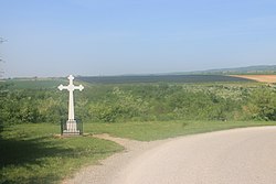
Grgeteg is located in the region of Syrmia, on the southern slopes of Fruška Gora. The village is situated in the northeast of the municipality of Irig, on the Kalin creek. Its territory extends for 632 hectares (1,560 acres), with a median altitude of 260 metres (850 ft) above sea level. It is the least densely populated place in Vojvodina.[1]
Grgeteg is located 25 kilometres (16 mi) from Novi Sad, 12 kilometres (7.5 mi) from Irig, and 24 kilometres (15 mi) from Ruma.[1]
History
The history of the village is closely tied to the Grgeteg Monastery, which was founded in the 15th century. The village itself was developed in the 18th century as a prnjavor,[a] a rural village inhabited by serfs who were dependent on the religious institution.[1]
According to tradition, the monastery was founded by the Serbian Despot, Vuk Grgurević in 1471; its existence is attested for the first time in 1545–1546. The konak of the monastery dates to the 18th century, and the church houses an iconostasis painted by Uroš Predić in 1902. The monastery is on the Serbian list of Immovable Cultural Heritage of Exceptional Importance.
Demography
| Year | 1948 | 1953 | 1961 | 1971 | 1981 | 1991 | 2002 | 2011 |
|---|---|---|---|---|---|---|---|---|
| Population | 107 | 115 | 136 | 126 | 78 | 73 | 85 | 76 |
Economy
The principal economic activity in Grgeteg is agriculture. Of the 632 hectares that make up the village, 307 of them (or 760 acres) are occupied by forest and 181 (450 acres) are cultivated. They mostly produce corn, wheat, and alfalfa.[1]
See also
Notes
- ^ A prnjavor is a type of rural settlement, in the immediate vicinity of a monastery, whose inhabitants cultivated once-large monastery estates and were dependent on the monastery for a livelihood. See Serbian Wikipedia article: Прњавор (тип насеља) [sr] – ['Prnjavor (type of settlement)'] (in Serbian)
References
- ^ a b c d Municipality of Irig (ed.). "Mesna zajednica Krušedol Prnjavor i Grgeteg". Retrieved 11 January 2013.
- v
- t
- e
Cities, towns and villages in the Srem District
- Velika Remeta
- Vrdnik
- Grgeteg
- Dobrodol
- Jazak
- Krušedol Prnjavor
- Krušedol Selo
- Mala Remeta
- Neradin
- Rivica
- Šatrinci
Municipalities or cities of Serbia
Authority control databases | |
|---|---|
| International |
|
| National |
|
45°08′N 19°54′E / 45.133°N 19.900°E / 45.133; 19.900
 | This Syrmia District, Vojvodina location article is a stub. You can help Wikipedia by expanding it. |
- v
- t
- e


