Gunning, New South Wales
Town in New South Wales, Australia
34°46′57″S 149°15′59″E / 34.782392°S 149.266400°E / -34.782392; 149.266400- 240 km (149 mi) SW of Sydney
- 74 km (46 mi) N of Canberra
- 46 km (29 mi) W of Goulburn
- 39 km (24 mi) E of Yass
- 310 km (193 mi) NE of Albury
| Localities around Gunning: | ||
| Dalton | Merrill | Gurrundah |
| Oolong | Gunning | Cullerin |
| Lade Vale | Bellmount Forest | Lerida |
Gunning is a small town on the Old Hume Highway, between Goulburn and Yass in the Southern Tablelands of New South Wales, Australia, about 260 km south-west of Sydney and 75 km north of the national capital, Canberra. Nearby towns and cities are Cullerin, Gundaroo, Dalton, Yass, Murrumbateman and Goulburn.
At the 2021 census, Gunning had a population of 820.[1] The Shire of Gunning (which was amalgamated into Upper Lachlan Shire in 2004) had a population of 2,280. The Gunning Wind Farm has been established to the town's northeast, and is visible from the Hume Highway.
History
The Gunning region was originally home to two Australian Aboriginal language groups, the Gundungurra people in the north and the Ngunnawal people in the south.
The region (specifically Gundaroo) was first explored by Europeans in 1820, and settled the next year by Hamilton Hume. In 1824, Hume and William Hovell left here to discover the overland route to Port Phillip Bay where Melbourne is sited. Land sales began in 1838. The nearby town of Dalton, now best known as the earthquake centre, was settled in 1847.
In 1865, Bushranger Ben Hall and his gang held up Kimberley's Inn, and a constable was shot dead.
In 1886 the town was described as
Wheat, maize, barley, and Oats are produced in the district Natural grass is plentiful and affords good pasture for flocks and herds. The Great Southern Railway Line passes near this town. The population is 409.[2]
Heritage listings
Gunning has a number of heritage-listed sites, including:
Population
In the 2016 Census, there were 659 people in Gunning. 86.9% of people were born in Australia and 91.4% of people spoke only English at home. The most common responses for religion were Anglican 30.4%, No Religion 25.8% and Catholic 22.6%.[1]
Transportation
Gunning was originally a coach stop, and service centre for the surrounding farms mainly growing Merino sheep. It has a police station and court house, post office, and school.
The Main Southern railway line from Sydney arrived in 1875 and was completed through to Albury in 1882. Gunning railway station is served by one daily NSW TrainLink XPT service in each direction operating between Sydney and Melbourne, and two weekly Xplorer service operating between Sydney and Griffith.[4]
Its main streets were built very wide, for the time of horse and bullock-drawn wagons. This served the town well when the main highway between Sydney and Melbourne carried cars and trucks through, until the Hume Highway by-pass was completed on 5 April 1993. The town has been able to resume a more rural pace of life, and develop something of an industry in providing bed and breakfast accommodation.
The establishment of the main trunk telegraph line is remembered by the Telegraph Hotel.
Attractions

A feature of the town is Bailey's Garage, once a very busy Holden dealership. One long exterior wall carries large images of nine notable Holden models.[5]
Notable residents
- Millicent Armstrong was a playwright and farmer in Gunning, New South Wales, who wrote primarily about the experiences of country life in early 20th century Australia. The plays she wrote while living in Gunning were well received and prize-winning.
Gallery
Interactive map of the town
-
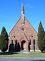 Uniting Church, Gunning
 -
 Old Gunning Court House
 -
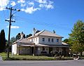
 Telegraph Hotel, Gunning
 -
 old St Francis Xavier church building
 -
 Holden Wall of Fame 1948 model 215 "FX"
 -
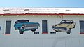 Holden Wall of Fame 1965 HD and 1968 HK


References
- ^ a b c Australian Bureau of Statistics (27 June 2017). "Gunning (State Suburb)". 2016 Census QuickStats. Retrieved 7 July 2017.

- ^ John Sands, The New atlas of Australia [Sydney, 1886] page 49.
- ^ "Gunning Railway Station and yard group". New South Wales State Heritage Register. Department of Planning & Environment. H01162. Retrieved 18 May 2018.
 Text is licensed by State of New South Wales (Department of Planning and Environment) under CC-BY 4.0 licence.
 - ^ "Southern timetable". NSW TrainLink. 7 September 2019.
- ^ "Bailey's Garage stands intact". Canberra Times. 24 April 2018. Retrieved 15 February 2023.
External links
Wikimedia Commons has media related to Gunning, New South Wales.
- Gunning info
- Gunning's Holden Wall of Fame
- v
- t
- e

- Bannaby
- Bannister
- Bellmount Forest
- Bevendale
- Biala
- Big Hill
- Blakney Creek
- Brayton
- Breadalbane
- Broadway
- Chatsbury
- Crooked Corner
- Cullerin
- Currawang
- Curraweela
- Fullerton
- Golspie
- Greenwich Park
- Gurrundah
- Jerrawa
- Lade Vale
- Lerida
- Limerick
- Lost River
- Merrill
- Myrtleville
- Middle Arm
- Narrawa
- Oolong
- Peelwood
- Pejar
- Pomeroy
- Richlands
- Roslyn
- Stonequarry
- Tarlo
- Tuena
- Wayo
- Wheeo
- Wiarborough
- Wollogorang
- Wombeyan Caves
- Woodhouselee
- Yalbraith
Main Article: Local government areas of New South Wales


