Jekerkwartier
Neighbourhood in Netherlands, Limburg, Maastricht
Jekerkwartier | |
|---|---|
neighbourhood | |
 Location of Jekerkwartier in Maastricht | |
| Municipality | Maastricht |
| Province | Limburg |
| Country | Netherlands |
| Population | |
| • Total | 1.541 |
The Jekerkwartier (Dutch pronunciation: [ˈjeːkərkʋɑrˌtiːr]; Limburgish: Jekerkerteer [ˈjeːkəʀkəʀˌteːʀ])[tone?] is a neighbourhood in the old city centre of Maastricht, Limburg, Netherlands. It is named after the Jeker river that flows through the neighbourhood into the Meuse.
Impressions
-
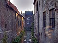
 Jeker near the Bisschopsmolen
 -
 Leeuwenmolen
 -
 Huis op de Jeker
 -
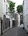 Typical street
 -
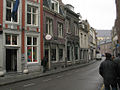
 Grote Looiersstraat
 -
 Sint Pieterstraat
 -
 Oude Minderbroederskerk
 -
![Helpoort [nl]](//upload.wikimedia.org/wikipedia/commons/thumb/2/21/Maastricht_Helpoort_BW_2017-08-19_13-58-28.jpg/81px-Maastricht_Helpoort_BW_2017-08-19_13-58-28.jpg) Helpoort [nl]
Helpoort [nl] -
 Nieuwenhof convent
 -
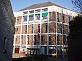 Conservatorium
 -
 City park
 -
 Poort Waerachtig
 -
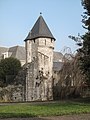 tower near the Faliezusterpark


![Helpoort [nl]](http://upload.wikimedia.org/wikipedia/commons/thumb/2/21/Maastricht_Helpoort_BW_2017-08-19_13-58-28.jpg/81px-Maastricht_Helpoort_BW_2017-08-19_13-58-28.jpg)


- v
- t
- e
| General |
|
|---|---|
| Education |
|
| History |
|

| Geology & Hydrology |
|
|---|---|
| Region / Urban area |
|
| Neighbourhoods |
|
| Local politics |
|
|---|---|
| International politics |
- A2 motorway
- Maastricht Aachen Airport (shared with Aachen, Germany)
- Maastricht railway station
- Maastricht Noord railway station
- Maastricht Randwyck railway station
- Hasselt – Maastricht tramway (cancelled)


50°50′39″N 5°41′29″E / 50.84417°N 5.69139°E / 50.84417; 5.69139


