Körösszakál
Place in Hajdú-Bihar, Hungary
Körösszakál Săcal | |
|---|---|
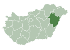
| Country |  Hungary Hungary |
| County | Hajdú-Bihar |
| Area | |
| • Total | 15.02 km2 (5.80 sq mi) |
| Population (2015) | |
| • Total | 833[1] |
| • Density | 55.6/km2 (144/sq mi) |
| Time zone | UTC+1 (CET) |
| • Summer (DST) | UTC+2 (CEST) |
| Postal code | 4136 |
| Area code | 54 |
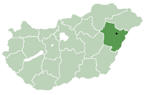
Körösszakál (Romanian: Săcal) is a village in Hajdú-Bihar county, in the Northern Great Plain region of eastern Hungary. The village is situated along the bank of the Crișul Repede.
Geography
It covers an area of 15.02 km2 (6 sq mi) and has a population of 833 people (2015).[1]
References
- ^ a b Gazetteer of Hungary, 1 January 2015. Hungarian Central Statistical Office. 3 September 2015
- v
- t
- e
- Debrecen (county seat)
- Álmosd
- Ártánd
- Bakonszeg
- Báránd
- Bedő
- Berekböszörmény
- Bihardancsháza
- Biharnagybajom
- Bihartorda
- Bocskaikert
- Bojt
- Darvas
- Ebes
- Esztár
- Folyás
- Fülöp
- Furta
- Gáborján
- Görbeháza
- Hajdúbagos
- Hajdúszovát
- Hencida
- Hortobágy
- Kismarja
- Kokad
- Konyár
- Körösszakál
- Körösszegapáti
- Magyarhomorog
- Mezőpeterd
- Mezősas
- Mikepércs
- Monostorpályi
- Nagyhegyes
- Nagykereki
- Nyíracsád
- Nyírmártonfalva
- Sáp
- Sáránd
- Szentpéterszeg
- Szerep
- Tépe
- Tetétlen
- Tiszagyulaháza
- Told
- Újiráz
- Újléta
- Újszentmargita
- Újtikos
- Váncsod
- Vekerd
- History
- Geography
- Government
- Economy
- Culture
- Tourism
47°01′N 21°36′E / 47.017°N 21.600°E / 47.017; 21.600
Authority control databases | |
|---|---|
| International |
|
| National |
|
 | This Hajdú-Bihar location article is a stub. You can help Wikipedia by expanding it. |
- v
- t
- e


