Kőtelek
Village in Jász-Nagykun-Szolnok, Hungary

Coat of arms
 Hungary
 (2015)
5062
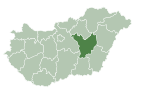
Kőtelek is a village in Jász-Nagykun-Szolnok county, in the Northern Great Plain region of central Hungary.
Geography
Kőtelek is located on the right bank of the Tisza, in the central-north-eastern part of the county, about 30 km northeast of Szolnok . The neighboring municipalities Nagykörű , Tiszasüly and Hunyadfalva or expelled from the left bank of Tiszabő. It covers an area of 45.13 km2 (17 sq mi) on the right bank of the river Tisza, and has a population of 1609 people (2015).[1]
References
- ^ a b Gazetteer of Hungary, 1 January 2015. Hungarian Central Statistical Office. 3 September 2015
External links
- Official site in Hungarian
- v
- t
- e
- Szolnok (district seat)

- Csataszög
- Hunyadfalva
- Kőtelek
- Nagykörű
- Rákócziújfalu
- Szajol
- Szászberek
- Tiszajenő
- Tiszasüly
- Tiszavárkony
- Tószeg
- Vezseny
- Zagyvarékas
| ||
|---|---|---|
| City with county rights |
|   |
| Towns | ||
| Large villages | ||
| Villages |
| |
| Other topics |
| |
 | This Jász-Nagykun-Szolnok location article is a stub. You can help Wikipedia by expanding it. |
- v
- t
- e


