Lac de la Haute-Sûre
Commune in Wiltz, Luxembourg
Lac de la Haute-Sûre Stauséigemeng | |
|---|---|
 | |
 Coat of arms | |
 Map of Luxembourg with Lac de la Haute-Sûre highlighted in orange, and the canton in dark red | |
| Coordinates: 49°55′12″N 5°50′49″E / 49.92°N 5.8469°E / 49.92; 5.8469 | |
| Country |  Luxembourg Luxembourg |
| Canton | Wiltz |
| Area | |
| • Total | 48.5 km2 (18.7 sq mi) |
| • Rank | 10th of 100 |
| Highest elevation | 537 m (1,762 ft) |
| • Rank | 7th of 100 |
| Lowest elevation | 284 m (932 ft) |
| • Rank | 86th of 100 |
| Population (2023) | |
| • Total | 2,253 |
| • Rank | 77th of 100 |
| • Density | 46/km2 (120/sq mi) |
| • Rank | 99th of 100 |
| Time zone | UTC+1 (CET) |
| • Summer (DST) | UTC+2 (CEST) |
| LAU 2 | LU0000806 |
| Website | lac-haute-sure.lu |
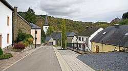
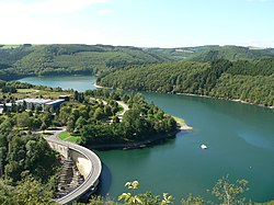
Lac de la Haute-Sûre (Luxembourgish: Stauséigemeng), (German: Stauseegemeinde) is a commune in the canton of Wiltz, in north-western Luxembourg. The commune is named after the Upper Sûre Lake, a reservoir on the upper Sauer river. Its administrative centre is Bavigne.
Lac de la Haute-Sûre was formed on 1 January 1979 from the former communes of Harlange and Mecher, both in Wiltz canton. The law creating Lac de la Haute-Sûre was passed on 23 December 1978.[1]
Populated places
The commune consists of the following villages:
|
Population
Graphs are unavailable due to technical issues. There is more info on Phabricator and on MediaWiki.org. |
References
External links
 Media related to Lac de la Haute-Sûre at Wikimedia Commons
- v
- t
- e
- Boulaide
- Esch-sur-Sûre
- Goesdorf
- Kiischpelt
- Lac de la Haute-Sûre
- Wiltz
- Winseler
Places adjacent to Lac de la Haute-Sûre | |
|---|---|


Wikimedia Commons has media related to Lac de la Haute-Sûre.
| Authority control databases |
|
|---|
 | This article related to the geography of Wiltz canton is a stub. You can help Wikipedia by expanding it. |
- v
- t
- e


