List of MBTA subway stations
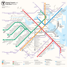
This is a list of MBTA subway stations in Boston and surrounding municipalities. All stations are operated by the Massachusetts Bay Transportation Authority. This list includes all rapid transit, light rail, and bus rapid transit (BRT) stations currently open on the MBTA's subway system. As of December 2022[update], the system has 153 stops and stations served by the Green, Blue, Red, Orange, and Silver lines.[1] These range in scale from marked stops on the Green and Silver lines with no fixed infrastructure, to sprawling underground complexes at the downtown transfer stations. Stations are typically named after nearby streets, squares, neighborhoods, or institutions[2]—e.g., Park Street, Central, Chinatown, and Airport, respectively.
An infill station on the Silver Line at Day Square is planned for opening in late 2024.[3][4] One additional Green Line station, Mystic Valley Parkway, is proposed but not funded.
Key
| Station | Indicates the MBTA's official name for the station; if the station is accessible, a wheelchair symbol ( ) appears next to the station name ) appears next to the station name |
|---|---|
| Line (branch) | Indicates the lines that stop at the given station; when all branches of a line stop at a station, only the line is shown |
| Connections | Denotes links to MBTA commuter rail, bus, and ferry routes, as well as other transit providers |
| City/neighborhood | Identifies the municipality (and in Boston, the neighborhood) in which the station is located |
| Station info | A link to the station's information page on the MBTA website |
| ‡ | Official transfer stations |
| † | Terminals |
| †‡ | Transfer station and terminal |
Stations
| Station | Line (branch) | Connections | City/neighborhood | Station info |
|---|---|---|---|---|
| 23 Drydock Avenue | Silver Line (SL2) | Boston/South Boston | Link | |
| 27 Drydock Avenue | Silver Line (SL2) | Boston/South Boston | Link | |
| Airport ‡ | Blue Line Silver Line (SL3) | MBTA bus (171)  Massport shuttles: 22, 33, 55, 66, 88 Massport shuttles: 22, 33, 55, 66, 88 | Boston/East Boston | Link |
| Alewife † | Red Line | 128 Business Council: A1, A2, A3, A4, A5, A6, R1, R2 | Cambridge/North Cambridge | Link |
| Allston Street | Green Line (B) | Boston/Allston | Link | |
| Amory Street | Green Line (B) | MBTA bus (57) | Boston/Fenway–Kenmore | Link |
| Andrew | Red Line | Boston/South Boston | Link | |
| Aquarium | Blue Line | MBTA bus (4) At Long Wharf: | Boston/Downtown | Link |
| Arlington | Green Line | Boston/Back Bay | Link | |
| Ashmont †‡ | Red Line (Ashmont) Red Line (Mattapan) | BAT: 12 | Boston/Dorchester | Link |
| Assembly | Orange Line | Somerville/Assembly Square | Link | |
| Babcock Street | Green Line (B) | MBTA bus (57) | Boston/Fenway–Kenmore | Link |
| Back Bay ‡ | Orange Line | Boston/Back Bay | Link | |
| Back of the Hill | Green Line (E) | MBTA bus (39, 192) | Boston/Mission Hill | Link |
| Ball Square | Green Line (E) | Somerville | Link | |
| Beachmont | Blue Line | MBTA bus (119) | Revere/Beachmont | Link |
| Beaconsfield | Green Line (D) | Brookline | Link | |
| Bellingham Square | Silver Line (SL3) | Chelsea/Bellingham Square | Link | |
| Blandford Street | Green Line (B) | MBTA bus (57) | Boston/Fenway–Kenmore | Link |
| Boston College † | Green Line (B) | Boston/Brighton | Link | |
| Boston University Central | Green Line (B) | Boston/Fenway–Kenmore | Link | |
| Boston University East | Green Line (B) | MBTA bus (57) | Boston/Fenway–Kenmore | Link |
| Bowdoin † | Blue Line | Boston/Beacon Hill | Link | |
| Box District | Silver Line (SL3) | Chelsea | Link | |
| Boylston | Green Line Silver Line (SL5) | MBTA bus (43) | Boston/Downtown | Link |
| Braintree †‡ | Red Line (Braintree) | Braintree | Link | |
| Brandon Hall | Green Line (C) | Brookline | Link | |
| Brigham Circle | Green Line (E) | Boston/Mission Hill | Link | |
| Broadway | Red Line | Boston/South Boston | Link | |
| Brookline Hills | Green Line (D) | MBTA bus (60) | Brookline | Link |
| Brookline Village | Green Line (D) | Brookline | Link | |
| Butler | Red Line (Mattapan) | Boston/Dorchester | Link | |
| Capen Street | Red Line (Mattapan) | Milton | Link | |
| Cedar Grove | Red Line (Mattapan) | Boston/Dorchester | Link | |
| Central | Red Line | Cambridge/Central Square | Link | |
| Central Avenue | Red Line (Mattapan) | MBTA bus (240) BAT: 12 | Milton | Link |
| Charles/MGH | Red Line | Boston/West End | Link | |
| Chelsea | Silver Line (SL3) | Chelsea | Link | |
| Chestnut Hill | Green Line (D) | Newton/Chestnut Hill | Link | |
| Chestnut Hill Avenue | Green Line (B) | MBTA bus (86) | Boston/Brighton | Link |
| Chinatown ‡ | Orange Line Silver Line (SL4, SL5) | MBTA bus (11) | Boston/Chinatown | Link |
| Chinatown Gate | Silver Line (SL4) | Boston/Chinatown | Link | |
| Chiswick Road | Green Line (B) | Boston/Brighton | Link | |
| Cleveland Circle †‡ | Green Line (C) | At Reservoir: Green Line (D) | Boston/Brighton | Link |
| Community College | Orange Line | Boston/Charlestown | Link | |
| Coolidge Corner | Green Line (C) | MBTA bus (66) | Brookline/Coolidge Corner | Link |
| Copley | Green Line | Boston/Back Bay | Link | |
| Courthouse | Silver Line (SL1, SL2, SL3, SLW) | MBTA bus (4) | Boston/South Boston | Link |
| Davis | Red Line | Somerville/Davis Square | Link | |
| Dean Road | Green Line (C) | Brookline | Link | |
| Design Center | Silver Line (SL2) | MBTA bus (4) | Boston/South Boston | Link |
| Downtown Crossing ‡ | Orange Line Red Line Silver Line (SL5) | At Park Street (via Winter Street Concourse): Green Line MBTA bus (43) | Boston/Downtown | Link |
| Drydock Avenue & Black Falcon Avenue | Silver Line (SL2) | Boston/South Boston | Link | |
| East Berkeley Street | Silver Line (SL4, SL5) | Boston/South End | Link | |
| East Somerville | Green Line (E) | Somerville | Link | |
| Eastern Avenue | Silver Line (SL3) | MBTA bus (112) | Chelsea | Link |
| Eliot | Green Line (D) | Newton/Newton Upper Falls | Link | |
| Englewood Avenue | Green Line (C) | Brookline | Link | |
| Fairbanks Street | Green Line (C) | Brookline | Link | |
| Fenway | Green Line (D) | Boston/Fenway–Kenmore | Link | |
| Fenwood Road | Green Line (E) | Boston/Mission Hill | Link | |
| Fields Corner | Red Line (Ashmont) | Boston/Dorchester | Link | |
| Forest Hills †‡ | Orange Line | Boston/Jamaica Plain | Link | |
| Gilman Square | Green Line (E) | MBTA bus (80) | Somerville | Link |
| Government Center †‡ | Blue Line | Boston/Downtown | Link | |
| Green Street | Orange Line | Boston/Jamaica Plain | Link | |
| Griggs Street | Green Line (B) | Boston/Allston | Link | |
| Harvard ‡ | Red Line | Cambridge/Harvard Square | Link | |
| Harvard Avenue | Green Line (B) | MBTA bus (66) | Boston/Allston | Link |
| Hawes Street | Green Line (C) | Brookline | Link | |
| Haymarket ‡ | Orange Line | Boston/Downtown | Link | |
| Heath Street † | Green Line (E) | Boston/Jamaica Plain | Link | |
| Herald Street | Silver Line (SL4, SL5) | Boston/South End | Link | |
| Hynes Convention Center | Boston/Back Bay | Link | ||
| Jackson Square | Orange Line | Boston/Jamaica Plain | Link | |
| JFK/UMass ‡ | Red Line | Boston/Dorchester | Link | |
| Kendall/MIT | Red Line | EZRide | Cambridge/Kendall Square | Link |
| Kenmore ‡ | At Lansdowne: | Boston/Fenway–Kenmore | Link | |
| Kent Street | Green Line (C) | Brookline | Link | |
| Lechmere | EZRide | Cambridge/Lechmere Square | Link | |
| Lenox Street | Silver Line (SL4, SL5) | MBTA bus (8) | Boston/Roxbury | Link |
| Longwood | Green Line (D) | Brookline | Link | |
| Longwood Medical Area | Green Line (E) | Boston/Mission Hill | Link | |
| Magoun Square | Green Line (E) | Somerville | Link | |
| Malden Center ‡ | Orange Line | Malden | Link | |
| Massachusetts Avenue | Orange Line | MBTA bus (1) | Boston/Fenway–Kenmore | Link |
| Massachusetts Avenue | Silver Line (SL4, SL5) | Boston/South End | Link | |
| Mattapan † | Red Line (Mattapan) | Boston/Mattapan | Link | |
| Maverick | Blue Line | Boston/East Boston | Link | |
| Medford/Tufts † | Green Line (E) | Medford | Link | |
| Melnea Cass Boulevard | Silver Line (SL4, SL5) | Boston/Roxbury | Link | |
| Milton | Red Line (Mattapan) | MBTA bus (217) | Milton | Link |
| Mission Park | Green Line (E) | Boston/Mission Hill | Link | |
| Museum of Fine Arts | Green Line (E) | Boston/Fenway–Kenmore | Link | |
| Newton Centre | Green Line (D) | MBTA bus (52) | Newton/Newton Centre | Link |
| Newton Highlands | Green Line (D) | MBTA bus (59) 128 Business Council: N1 | Newton/Newton Highlands | Link |
| Newton Street | Silver Line (SL4, SL5) | Boston/South End | Link | |
| North Quincy | Red Line (Braintree) | Quincy/North Quincy | Link | |
| North Station ‡ | Orange Line | Downeaster MBTA bus (4) EZRide | Boston/West End | Link |
| Northeastern University | Green Line (E) | MBTA bus (39) | Boston/Fenway–Kenmore | Link |
| Northern Avenue & Harbor Street | Silver Line (SL2) | MBTA bus (4) | Boston/South Boston | Link |
| Northern Avenue & Tide Street | Silver Line (SL2) | MBTA bus (4) | Boston/South Boston | Link |
| Nubian | Silver Line (SL4, SL5) | Boston/Roxbury | Link | |
| Oak Grove † | Orange Line | Malden | Link | |
| Orient Heights | Blue Line | Boston/East Boston | Link | |
| Packards Corner | Green Line (B) | MBTA bus (57) | Boston/Allston | Link |
| Park Street ‡ | Red Line Green Line | MBTA bus (43) At Downtown Crossing (via Winter Street Concourse): Orange Line Silver Line (SL5) | Boston/Downtown | Link |
| Porter | Red Line | Cambridge/Porter Square | Link | |
| Prudential | Green Line (E) | Boston/Back Bay | Link | |
| Quincy Adams | Red Line (Braintree) | Quincy/South Quincy | Link | |
| Quincy Center ‡ | Red Line (Braintree) | Quincy/Quincy Center | Link | |
| Reservoir ‡ | Green Line (D) | At Cleveland Circle: Green Line (C) | Brookline | Link |
| Revere Beach | Blue Line | Revere | Link | |
| Riverside † | Green Line (D) | MBTA bus (558) MWRTA: MassBay Riverside Shuttle | Newton/Auburndale | Link |
| Riverway | Green Line (E) | Boston/Mission Hill | Link | |
| Roxbury Crossing | Orange Line | Boston/Roxbury | Link | |
| Ruggles ‡ | Orange Line | Boston/Roxbury | Link | |
| Savin Hill | Red Line (Ashmont) | Boston/Dorchester | Link | |
| Science Park | – | Boston/West End | Link | |
| Shawmut | Red Line (Ashmont) | Boston/Dorchester | Link | |
| Silver Line Way ‡ | Silver Line (SL1, SL2, SL3, SLW) | Boston/South Boston | Link | |
| South Station †‡ | Red Line Silver Line (SL1, SL2, SL3, SL4, SLW) | Intercity buses at South Station Bus Terminal | Boston/Downtown | Link |
| South Street | Green Line (B) | Boston/Brighton | Link | |
| St. Mary's Street | Green Line (C) | Brookline | Link | |
| St. Paul Street | Green Line (C) | Brookline | Link | |
| State ‡ | Blue Line Orange Line | Boston/Downtown | Link | |
| Stony Brook | Orange Line | Boston/Jamaica Plain | Link | |
| Suffolk Downs | Blue Line | Boston/East Boston | Link | |
| Sullivan Square | Orange Line | Boston/Charlestown | Link | |
| Summit Avenue | Green Line (C) | Brookline | Link | |
| Sutherland Road | Green Line (B) | Boston/Brighton | Link | |
| Symphony | Green Line (E) | Boston/Fenway–Kenmore | Link | |
| Tappan Street | Green Line (C) | Brookline | Link | |
| Terminal A | Silver Line (SL1) | MBTA bus (171) Massport shuttles: 11, 22, 55, 66, 88 Intercity buses and Logan Express | Boston/East Boston | Link |
| Terminal B Stop 1 | Silver Line (SL1) | MBTA bus (171) Massport shuttles: 11, 22, 55, 66, 88 Intercity buses and Logan Express | Boston/East Boston | Link |
| Terminal B Stop 2 | Silver Line (SL1) | MBTA bus (171) Massport shuttles: 11, 22, 55, 66, 88 Intercity buses and Logan Express | Boston/East Boston | Link |
| Terminal C | Silver Line (SL1) | MBTA bus (171) Massport shuttles: 11, 33, 55, 66, 88 Intercity buses and Logan Express | Boston/East Boston | Link |
| Terminal E | Silver Line (SL1) | MBTA bus (171) Massport shuttles: 11, 33, 55, 66, 88 Intercity buses and Logan Express | Boston/East Boston | Link |
| Tufts Medical Center ‡ | Orange Line Silver Line (SL4, SL5) | Boston/Chinatown | Link | |
| Union Park Street | Silver Line (SL4, SL5) | Boston/South End | Link | |
| Union Square † | Green Line (D) | Somerville/Union Square | Link | |
| Valley Road | Red Line (Mattapan) | Milton | Link | |
| Waban | Green Line (D) | Newton/Waban | Link | |
| Warren Street | Green Line (B) | Boston/Brighton | Link | |
| Washington Square | Green Line (C) | MBTA bus (65) | Brookline | Link |
| Washington Street | Green Line (B) | MBTA bus (65) | Boston/Brighton | Link |
| Wellington | Orange Line | Medford | Link | |
| Wollaston | Red Line (Braintree) | MBTA bus (211) | Quincy/Wollaston | Link |
| Wonderland † | Blue Line | Revere | Link | |
| Wood Island | Blue Line | Boston/East Boston | Link | |
| Woodland | Green Line (D) | MWRTA: 1, Weekend GLC | Newton/Newton Lower Falls | Link |
| Worcester Square | Silver Line (SL4, SL5) | MBTA bus (8) | Boston/South End | Link |
| World Trade Center | Silver Line (SL1, SL2, SL3, SLW) | Boston/South Boston | Link |
-
 Averaging over 24,000 weekday boardings, South Station is the busiest MBTA subway station.
 -
 Park Street station is a busy transfer point for the Green Line and Red Line
 -
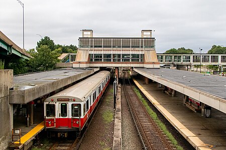 JFK/UMass station is one of several transfer points between the subway and Commuter Rail systems.
 -
 Suffolk Downs station, a typical station outside the downtown core
 -
 Most newer rail stations, like Massachusetts Avenue, have island platforms.
 -
 Griggs Street station, a typical non-accessible Green Line surface stop
 -
 Fenway station, an accessible stop on the Green Line D branch
 -
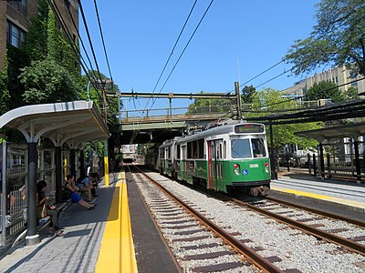
 Union Park Street, a typical Silver Line street stop


Former stations
Closed without replacement
This listing includes stations that have closed during the MBTA era (since 1964) without replacement by another rapid transit station. Most former stops on Green Line A branch and the outer section of the Green Line E branch, which were merely marked stopping locations rather than platforms, are not listed.


| Station | Line (branch) | City/neighborhood | Date closed | Refs |
|---|---|---|---|---|
| 88 Black Falcon Avenue | Silver Line (SL2) | Boston/Seaport | April 2019 | [5][6] |
| Arborway | Green Line (E) | Boston/Jamaica Plain | December 28, 1985 | [6] |
| Black Falcon Avenue & Design Center Place | Silver Line (SL2) | Boston/Seaport | June 21, 2014 | |
| Carlton Street | Green Line (C) | Brookline | July 24, 1982 | |
| City Point | Silver Line (SL3) | Boston/South Boston | March 20, 2009 | [6] |
| City Square | Orange Line (Charlestown Elevated) | Boston/Charlestown | April 4, 1975 | [6] |
| East 1st Street & M Street | Silver Line (SL3) | Boston/South Boston | March 20, 2009 | [6] |
| Egleston | Orange Line (Washington Street Elevated) | Boston/Roxbury | April 30, 1987 | [6] |
| Everett | Orange Line (Charlestown Elevated) | Everett | April 4, 1975 | [6] |
| Farragut Road | Silver Line (SL3) | Boston/South Boston | August 20, 2005 | [6] |
| Fordham Road | Green Line (B) | Boston/Allston | April 20, 2004 | [7] |
| Forsyth Street | Green Line (E) | Boston/Fenway–Kenmore | March 22, 1980 | |
| Greycliff Road | Green Line (B) | Boston/Brighton | April 20, 2004 | [7] |
| Mount Hood Road | Green Line (B) | Boston/Brighton | April 20, 2004 | [7] |
| Newton Corner | Green Line (A) | Newton | June 21, 1969 | [6] |
| Oak Square | Green Line (A) | Boston/Brighton | June 21, 1969 | [6] |
| Parker Street | Green Line (E) | Boston/Fenway–Kenmore | March 22, 1980 | |
| Stadium | Red Line | Cambridge | November 18, 1967 | [6] |
| Strathmore Road | Green Line (C) | Brookline | July 24, 1982 | |
| Summer Street & Powerhouse Street | Silver Line (SL3) | Boston/South Boston | March 20, 2009 | [6] |
| Summit Avenue | Green Line (B) | Boston/Brighton | April 20, 2004 | [7] |
| Thompson Square | Orange Line (Charlestown Elevated) | Boston/Charlestown | April 4, 1975 | [6] |
| Union Square | Green Line (A) | Boston/Allston | June 21, 1969 | [6] |
| University Road | Green Line (B) | Boston/Fenway–Kenmore | c. 1975 | |
| Vancouver Street | Green Line (E) | Boston/Fenway–Kenmore | March 22, 1980 | |
| Watertown Yard | Green Line (A) | Watertown | June 21, 1969 | [6] |
| Wigglesworth Street | Green Line (E) | Boston/Longwood Medical Area | March 22, 1980 | |
| Winchester Street | Green Line (C) | Brookline | July 24, 1982 | |
| Winthrop Road | Green Line (C) | Brookline | July 24, 1982 |
Closed with replacement


This listing includes stations that have closed during the MBTA era (since 1964), but were replaced with another rapid transit station. This includes stations rebuilt nearby on a different routing of the same line (such as Forest Hills when the Washington Street Elevated was replaced with the Southwest Corridor), temporary stations (such as Harvard/Brattle), and stations replaced with Silver Line stops (such as Dover). Most MBTA rapid transit stations have been rebuilt or substantially renovated on the same routing; these are not included.
| Station | Line (branch) | City/neighborhood | Date closed | Replacement type | Refs |
|---|---|---|---|---|---|
| Alcorn Street | Green Line (B) | Boston/Allston | c. 1975 | Replaced with Babcock Street | |
| Boston University West | Green Line (B) | Boston/Allston | November 12, 2021 | Replaced with Amory Street | [8] |
| Dover | Boston/South End | April 30, 1987 | Replaced with East Berkeley Street in 2002 | [6] | |
| Dudley Square | Boston/Roxbury | April 30, 1987 | Replaced with Nubian in 2002 | [6] | |
| Forest Hills | Boston/Jamaica Plain | April 30, 1987 | Rebuilt slightly west as part of Southwest Corridor construction | [6] | |
| Foster Street | Green Line (B) | Boston/Brighton | 1970 | Replaced by Greycliff Street | |
| Green Street | Boston/Jamaica Plain | April 30, 1987 | Rebuilt several blocks west as part of Southwest Corridor construction | [6] | |
| Harvard | Red Line | Cambridge | January 30, 1981 | Rebuilt slightly north during Red Line Northwest Extension construction | [6] |
| Harvard/Brattle | Red Line | Cambridge | September 2, 1983 | Temporary station during Harvard station reconstruction | [6] |
| Harvard/Holyoke | Red Line | Cambridge | September 2, 1983 | Temporary station during Harvard station reconstruction | [6] |
| Leamington Road | Green Line (B) | Boston/Brighton | June 21, 1980 | Consolidated into Sutherland Road | |
| Lechmere | Green Line (E) | Cambridge | May 24, 2020 | Rebuilt nearby as part of the Green Line Extension | [6] |
| Northampton | Boston/South End | April 30, 1987 | Replaced with Massachusetts Avenue in 2002 | [6] | |
| Pleasant Street | Green Line (B) | Boston/Allston | February 26, 2021 | Replaced with Babcock Street | [9] |
| St. Paul Street | Green Line (B) | Boston/Allston | November 12, 2021 | Replaced with Amory Street | [8] |
| Sullivan Square | Boston/Charlestown | April 4, 1975 | Rebuilt nearby as part of the Haymarket North Extension | [6] |
See also
References
- ^ "Rapid Transit/Key Bus Routes Map". Massachusetts Bay Transportation Authority.
- ^ MBTA Station Naming Policy, Massachusetts Bay Transportation Authority, 2018, retrieved June 21, 2022
- ^ PLAN: East Boston (Report). Boston Planning & Development Agency. January 10, 2024. pp. 108, 109.
- ^ "BPDA Board adopts East Boston Tomorrow: PLAN: East Boston planning initiative" (Press release). Boston Planning & Development Agency. January 18, 2024.
- ^ "SL2 Design Center–South Station". Alerts. Massachusetts Bay Transportation Authority. April 27, 2019. Archived from the original on October 1, 2019.
- ^ a b c d e f g h i j k l m n o p q r s t u v w x y Belcher, Jonathan. "Changes to Transit Service in the MBTA district" (PDF). Boston Street Railway Association.
- ^ a b c d Daniel, Mac (16 March 2005). "T drops 4 Green Line stops after results of rider survey". Boston Globe. Archived from the original on 18 March 2005. Retrieved 6 February 2014.
- ^ a b "New Babcock Street and Amory Street Stations Open November 15" (Press release). Massachusetts Bay Transportation Authority. November 12, 2021.
- ^ "B Branch Station Consolidation Project: Virtual Public Meeting" (PDF). Massachusetts Bay Transportation Authority. January 28, 2021.
External links
- MBTA - Subway
- v
- t
- e
(List of stations)
| Heavy rail |
|
|---|---|
| Light rail | |
| Infrastructure | |
| Former lines |
(List of stations)
| North Station lines | |
|---|---|
| South Station lines | |
| Former lines |
- Silver Line
- List of routes
- Crosstown routes
- Key routes
- Boat
- The Ride (paratransit)
| Under construction | |
|---|---|
| In planning/proposed |
|
| Predecessor companies |
|---|


