List of historic places in western Newfoundland
This article is a list of historic places in western Newfoundland. These properties are entered on the Canadian Register of Historic Places, whether they are federal, provincial, or municipal. The list contains entries from communities in census divisions 4, 5, and 9, encompassing the western portions of the island of Newfoundland.
Map all coordinates using OpenStreetMap
Download coordinates as:
- KML
- GPX (all coordinates)
- GPX (primary coordinates)
- GPX (secondary coordinates)
List of historic places
| Name | Address | Coordinates | Government recognition (CRHP №) | Image | |
|---|---|---|---|---|---|
| Adams Home | Cape Onion NL | 51°36′36″N 55°37′31″W / 51.61°N 55.6254°W / 51.61; -55.6254 (Adams Home, Cape Onion) | Newfoundland and Labrador (1895) | 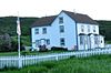 | |
| Bank of Montreal | 322 Curling Street Corner Brook NL | 48°57′30″N 57°59′41″W / 48.9582°N 57.9948°W / 48.9582; -57.9948 (Bank of Montreal) | Newfoundland and Labrador (2340) |  Upload Photo | |
| Nurse Myra Bennett House Registered Heritage Structure | Daniel's Harbour NL | 50°14′00″N 57°35′00″W / 50.2333°N 57.5833°W / 50.2333; -57.5833 (Nurse Myra Bennett House Registered Heritage Structure) | Newfoundland and Labrador (2186) | 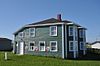 | |
| Blanchard House | Woody Point NL | 49°30′17″N 57°54′54″W / 49.5046°N 57.9149°W / 49.5046; -57.9149 (Blanchard House, Woody Point) | Newfoundland and Labrador (19590), Woody Point municipality (4036) | 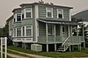 | |
| Bond Store | Woody Point NL | 49°30′17″N 57°54′47″W / 49.5047°N 57.913°W / 49.5047; -57.913 (Bond Store, Woody Point) | Woody Point municipality (4048) | 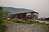 | |
| Bonne Bay Cottage Hospital Municipal Heritage Building | Norris Point NL | 49°32′18″N 57°52′57″W / 49.5382°N 57.8824°W / 49.5382; -57.8824 (Bonne Bay Cottage Hospital Municipal Heritage Building) | Norris Point municipality (5262) | 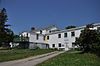 | |
| Walter F. Butt House | Woody Point NL | 49°30′07″N 57°54′58″W / 49.502°N 57.9162°W / 49.502; -57.9162 (Walter F. Butt House, Woody Point) | Woody Point municipality (4050) | 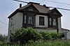 | |
| John William Caines House Registered Heritage Structure | Norris Point NL | 49°31′06″N 57°52′39″W / 49.5182°N 57.8776°W / 49.5182; -57.8776 (John William Caines House Registered Heritage Structure) | Newfoundland and Labrador (18906) | Upload Photo | |
| Casey Store | Conche NL | 50°53′39″N 55°53′53″W / 50.8942°N 55.8981°W / 50.8942; -55.8981 (Casey Store, Conche) | Newfoundland and Labrador (2034), Conche municipality (11947) | Upload Photo | |
| Captain Coubelongue Grave Site Municipal Heritage Site | Conche NL | 50°54′08″N 55°53′19″W / 50.9021°N 55.8885°W / 50.9021; -55.8885 (Captain Coubelongue Grave Site Municipal Heritage Site, Conche) | Conche municipality (11945) | Upload Photo | |
| Cape Anguille Lightkeeper's Residence | Codroy NL | 47°54′00″N 59°24′39″W / 47.9°N 59.4107°W / 47.9; -59.4107 (Cape Anguille Lightkeeper's Residence) | Newfoundland and Labrador (2090) | 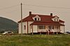 | |
| Cape Anguille Light Tower | Codroy NL | 47°53′54″N 59°24′39″W / 47.8983°N 59.4108°W / 47.8983; -59.4108 (Cape Anguille Light Tower) | Federal (13089, (20853) | 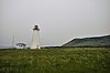 | |
| Cape Bauld Light Tower | Quirpon Island NL | 51°38′21″N 55°25′42″W / 51.6391°N 55.4282°W / 51.6391; -55.4282 (Cape Bauld Light Tower) | Federal (13014) | Upload Photo | |
| 067 Central Street | 67 Central Street Corner Brook NL | 48°57′05″N 57°55′58″W / 48.9513°N 57.9328°W / 48.9513; -57.9328 (67 Central Street) | Newfoundland and Labrador (2341) |  | |
| Corner Brook Public Building | Corner Brook NL | 48°57′10″N 57°56′41″W / 48.9529°N 57.9448°W / 48.9529; -57.9448 (Corner Brook Public Building) | Newfoundland and Labrador (2342) | 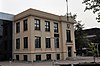 | |
| Cow Head Light | Cow Head NL | 49°55′11″N 57°48′49″W / 49.9198°N 57.8137°W / 49.9198; -57.8137 (Cow Head Light) | Cow Head municipality (3840) | 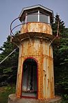 | |
| George and Jane Crocker House | Woody Point NL | 49°30′02″N 57°54′50″W / 49.5005°N 57.9139°W / 49.5005; -57.9139 (George and Jane Crocker House, Woody Point) | Woody Point municipality (4040) |  | |
| Jacob A. Crocker House | Trout River NL | 49°28′51″N 58°07′40″W / 49.4809°N 58.1277°W / 49.4809; -58.1277 (Jacob A. Crocker House) | Newfoundland and Labrador (2176) | 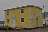 | |
| East Side Interdenominational Cemetery Municipal Heritage Site | St. Anthony NL | 51°21′50″N 55°34′08″W / 51.364°N 55.569°W / 51.364; -55.569 (East Side Interdenominational Cemetery Municipal Heritage Site) | St. Anthony municipality (10191) | 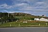 | |
| Stanley Ford Home and Outbuildings Municipal Heritage Site | Jackson's Arm NL | 49°51′56″N 56°47′45″W / 49.8656°N 56.7957°W / 49.8656; -56.7957 (Stanley Ford Home and Outbuildings Municipal Heritage Site) | Jackson's Arm municipality (5381) | Upload Photo | |
| Glynmill Inn Registered Heritage Structure | Corner Brook NL | 48°56′56″N 57°56′23″W / 48.9488°N 57.9398°W / 48.9488; -57.9398 (Glynmill Inn Registered Heritage Structure, Corner Brook) | Newfoundland and Labrador (8579) | 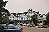 | |
| Gravesite of Cow Head's First Settlers | Cow Head NL | 49°55′21″N 57°48′29″W / 49.9224°N 57.8081°W / 49.9224; -57.8081 (Gravesite of Cow Head's First Settlers) | Cow Head municipality (4033) | Upload Photo | |
| Grenfell House | St. Anthony NL | 51°22′00″N 55°35′00″W / 51.3667°N 55.5833°W / 51.3667; -55.5833 (Grenfell House, St. Anthony) | Newfoundland and Labrador (2324) |  | |
| The Grenfell Plaques Municipal Heritage Site | on the grounds of the Grenfell House Museum St. Anthony NL | 51°21′59″N 55°35′00″W / 51.3665°N 55.5833°W / 51.3665; -55.5833 (The Grenfell Plaques Municipal Heritage Site) | St. Anthony municipality (10171) |  | |
| Haliburton House | 53 Water Street Woody Point NL | 49°30′13″N 57°54′46″W / 49.5036°N 57.9129°W / 49.5036; -57.9129 (Haliburton House, Woody Point) | Woody Point municipality (4049) | Upload Photo | |
| Hezikiah House | Woody Point NL | 49°30′02″N 57°55′09″W / 49.5006°N 57.9191°W / 49.5006; -57.9191 (Hezikiah House, Woody Point) | Newfoundland and Labrador (2300) | 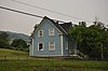 | |
| Holy Trinity Anglican Church Registered Heritage Structure | Codroy NL | 47°51′19″N 59°16′13″W / 47.8552°N 59.2703°W / 47.8552; -59.2703 (Holy Trinity Anglican Church Registered Heritage Structure, Codroy) | Newfoundland and Labrador (1947) |  | |
| Hulan House | Jeffrey's NL | 48°14′00″N 58°50′42″W / 48.2333°N 58.845°W / 48.2333; -58.845 (Hulan House, Jeffrey's) | Newfoundland and Labrador (2091) | Upload Photo | |
| International Pulp and Paper Company Staff House | Deer Lake NL | 49°10′14″N 57°25′57″W / 49.1705°N 57.4325°W / 49.1705; -57.4325 (International Pulp and Paper Company Staff House, Deer Lake) | Newfoundland and Labrador (2181) |  | |
| Jenniex House Municipal Heritage Building | Norris Point NL | 49°31′28″N 57°53′06″W / 49.5244°N 57.8849°W / 49.5244; -57.8849 (Jenniex House Municipal Heritage Building, Norris Point) | Norris Point municipality (8142) | 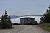 | |
| Keeper's Dwelling | Belle Isle NL | 51°52′58″N 55°23′10″W / 51.8828°N 55.3861°W / 51.8828; -55.3861 (Keeper's Dwelling, Belle Isle) | Federal (3629) | Upload Photo | |
| L'Anse aux Meadows National Historic Site of Canada | 11 km north of Saint-Luniare St. Anthony NL | 51°35′54″N 55°33′42″W / 51.5984°N 55.5618°W / 51.5984; -55.5618 (L'Anse aux Meadows National Historic Site of Canada) | Federal (4219) |  | |
| Lighttower | Belle Isle Belle Isle NL | 51°52′59″N 55°23′04″W / 51.8830°N 55.3845°W / 51.8830; -55.3845 (Lighttower (Belle Isle 1905 Light)) | Federal (3904) | Upload Photo | |
| New Férolle Peninsula Lighthouse | Ferolle Point New Ferolle NL | 51°01′14″N 57°05′37″W / 51.0206°N 57.0936°W / 51.0206; -57.0936 (New Ferolle Peninsula Lighthouse) | Federal (3619, (20800) | 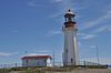 | |
| Lobster Cove Head Lighthouse | Main Street North Rocky Point NL | 49°36′10″N 57°57′20″W / 49.6029°N 57.9556°W / 49.6029; -57.9556 (Lobster Cove Head Lighthouse) | Federal (4813) | 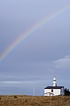 More images | |
| Lord Nelson Loyal Orange Lodge LOL #149 | Woody Point, Bonne Bay NL | 49°30′10″N 57°55′03″W / 49.5028°N 57.9176°W / 49.5028; -57.9176 (Lord Nelson Loyal Orange Lodge LOL #149, Woody Point) | Newfoundland and Labrador (2177) | 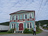 | |
| Belle Isle South End Lower Lighthouse | Belle Isle NL | 51°52′58″N 55°23′10″W / 51.8828°N 55.3861°W / 51.8828; -55.3861 (Belle Isle South End Lower Lighthouse) | Federal (3628, (21136) | Upload Photo | |
| Lourdes Land Settlement Site Municipal Heritage Site | Lourdes NL | 48°38′54″N 58°59′50″W / 48.6483°N 58.9971°W / 48.6483; -58.9971 (Lourdes Land Settlement Site Municipal Heritage Site) | Lourdes municipality (8009) | 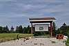 | |
| Martinique Bay Provincial Historic Site | Conche NL | 50°54′03″N 55°53′59″W / 50.9008°N 55.8997°W / 50.9008; -55.8997 (Martinique Bay Provincial Historic Site, Conche) | Newfoundland and Labrador (3083) | Upload Photo | |
| Arnold Morris House | St. George's NL | 48°26′00″N 58°28′49″W / 48.4333°N 58.4803°W / 48.4333; -58.4803 (Arnold Morris House, St. George's) | Newfoundland and Labrador (2281) | Upload Photo | |
| Old Anglican Cemetery Municipal Heritage Site | Anchor Point NL | 51°14′05″N 56°47′58″W / 51.2348°N 56.7994°W / 51.2348; -56.7994 (Old Anglican Cemetery Municipal Heritage Site, Anchor Point) | Anchor Point municipality (8060) | 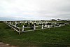 More images | |
| Old Anglican Cemetery Municipal Heritage Site | St. Paul's NL | 49°51′26″N 57°49′11″W / 49.8571°N 57.8197°W / 49.8571; -57.8197 (Old Anglican Cemetery Municipal Heritage Site, St. Pauls) | St. Paul's municipality (12917) | Upload Photo | |
| Old Anglican Cemetery | Cow Head NL | 49°55′16″N 57°48′24″W / 49.9212°N 57.8066°W / 49.9212; -57.8066 (Old Anglican Cemetery, Cow Head) | Cow Head municipality (4034) |  | |
| Old Church of England Cemetery Municipal Heritage Site | 023C North Street, northwest of the Roman Catholic Church Parson's Pond NL | 50°02′08″N 57°42′27″W / 50.0355°N 57.7076°W / 50.0355; -57.7076 (Old Church of England Cemetery Municipal Heritage Site) | Parson's Pond municipality (8333) | Upload Photo | |
| Old Anglican Cemetery | 14 Shore Road Woody Point NL | 49°30′00″N 57°54′59″W / 49.5000°N 57.9165°W / 49.5000; -57.9165 (Old Anglican Cemetery (Woody Point)) | Woody Point municipality (4035) | Upload Photo | |
| Old Loft Restaurant/Jersey Room Crafts | Woody Point NL | 49°30′02″N 57°54′49″W / 49.5006°N 57.9136°W / 49.5006; -57.9136 (Old Loft Restaurant/Jersey Room Crafts, Woody Point) | Woody Point municipality (4032) |  | |
| Old Roman Catholic Cemetery Municipal Heritage Site | St. Pauls NL | 49°51′24″N 57°49′10″W / 49.8568°N 57.8195°W / 49.8568; -57.8195 (Old Roman Catholic Cemetery Municipal Heritage Site, St. Pauls) | St. Pauls municipality (12920) | Upload Photo | |
| William and Cecilia O'Neill Property | Conche NL | 50°53′36″N 55°53′55″W / 50.8934°N 55.8985°W / 50.8934; -55.8985 (William and Cecilia O'Neill Property, Conche) | Newfoundland and Labrador (2183), Conche municipality (11946) | Upload Photo | |
| Our Lady of Mercy Church Registered Heritage Structure | Port au Port NL | 48°33′00″N 58°46′00″W / 48.55°N 58.7667°W / 48.55; -58.7667 (Our Lady of Mercy Church Registered Heritage Structure, Port au Port) | Newfoundland and Labrador (2280) |  | |
| Dr. Henry N. Payne Community Museum | Cow Head NL | 49°54′47″N 57°47′41″W / 49.913°N 57.7948°W / 49.913; -57.7948 (Dr. Henry N. Payne Community Museum, Cow Head) | Cow Head municipality (3841) |  | |
| 1942 Plane Crash Municipal Heritage Site | Conche NL | 50°52′58″N 55°53′35″W / 50.8828°N 55.8931°W / 50.8828; -55.8931 (1942 Plane Crash Municipal Heritage Site, Conche) | Conche municipality (11949) | Upload Photo | |
| Port au Choix National Historic Site of Canada | Port au Choix NL | 50°42′32″N 57°22′47″W / 50.7088°N 57.3796°W / 50.7088; -57.3796 (Port au Choix National Historic Site of Canada) | Federal (11464) |  | |
| Prebble House | Woody Point NL | 49°30′07″N 57°54′49″W / 49.502°N 57.9137°W / 49.502; -57.9137 (Prebble House, Woody Point) | Woody Point municipality (4051) |  | |
| Precious Blood Church and Bell House | St. Andrew's NL | 47°46′35″N 59°16′48″W / 47.7764°N 59.28°W / 47.7764; -59.28 (Precious Blood Church and Bell House, St. Andrew's) | Newfoundland and Labrador (2238) |  | |
| William Henry Pynn House | Quirpon NL | 51°34′49″N 55°26′00″W / 51.5803°N 55.4333°W / 51.5803; -55.4333 (William Henry Pynn House) | Newfoundland and Labrador (2094) | Upload Photo | |
| The Quidnock Municipal Heritage Site | Conche NL | 50°53′01″N 55°53′48″W / 50.8835°N 55.8968°W / 50.8835; -55.8968 (The Quidnock Municipal Heritage Site, Conche) | Conche municipality (11948) | Upload Photo | |
| Quirpon Island Lightkeeper's Residence | Cape Bauld NL | 51°38′24″N 55°25′40″W / 51.64°N 55.4278°W / 51.64; -55.4278 (Quirpon Island Lightkeeper's Residence) | Newfoundland and Labrador (3182) | Upload Photo | |
| Roberts Store | Woody Point NL | 49°30′11″N 57°54′47″W / 49.5031°N 57.913°W / 49.5031; -57.913 (Roberts Store) | Woody Point municipality (4037) |  | |
| Edward J. Roberts House | Woody Point NL | 49°30′09″N 57°54′48″W / 49.5025°N 57.9133°W / 49.5025; -57.9133 (Edward J. Roberts House) | Woody Point municipality (4052) |  | |
| John William Roberts House | Woody Point NL | 49°30′12″N 57°54′51″W / 49.5033°N 57.9142°W / 49.5033; -57.9142 (John William Roberts House) | Newfoundland and Labrador (2190) |  | |
| St. Barnabas Anglican Church | Flower's Cove NL | 51°17′48″N 56°44′01″W / 51.2968°N 56.7336°W / 51.2968; -56.7336 (St. Barnabas Anglican Church) | Newfoundland and Labrador (2105) |  | |
| St. George's Courthouse Registered Heritage Structure | St. George's NL | 48°26′00″N 58°28′49″W / 48.4333°N 58.4803°W / 48.4333; -58.4803 (St. George's Courthouse Registered Heritage Structure) | Newfoundland and Labrador (2111) |  | |
| St. Joseph's Roman Catholic Church | St. George's NL | 48°26′00″N 58°28′49″W / 48.4334°N 58.4803°W / 48.4334; -58.4803 (St. Joseph's Roman Catholic Church, St. George's) | Newfoundland and Labrador (2241) | 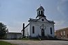 | |
| St. Patrick's Church | Woody Point, Bonne Bay NL | 49°29′59″N 57°55′13″W / 49.4998°N 57.9202°W / 49.4998; -57.9202 (St. Patrick's Church, Woody Point) | Newfoundland and Labrador (2180) | 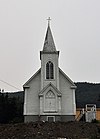 | |
| Julius Swirsky Clothing Store Registered Heritage Structure | Corner Brook NL | 48°57′06″N 57°57′05″W / 48.9516°N 57.9515°W / 48.9516; -57.9515 (Julius Swirsky Clothing Store Registered Heritage Structure) | Newfoundland and Labrador (10843) | 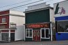 | |
| Tower | Port au Choix NL | 50°41′53″N 57°24′39″W / 50.6981°N 57.4109°W / 50.6981; -57.4109 (Tower (Port au Choix/Point Riche Light)) | Federal (9731) |  | |
| Upper Light Recognized Federal Heritage Building | Belle Isle NL | 51°52′58″N 55°23′10″W / 51.8828°N 55.3861°W / 51.8828; -55.3861 (Upper Light (Belle Isle 1857 Light)) | Federal (3905) | Upload Photo | |
| War Memorial Municipal Heritage Structure | St. Anthony NL | 51°21′39″N 55°34′54″W / 51.3607°N 55.5818°W / 51.3607; -55.5818 (War Memorial Municipal Heritage Structure, St. Anthony) | St. Anthony municipality (8334) | 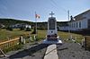 | |
| Wicks Store Municipal Heritage Site | Jackson's Arm NL | 49°51′54″N 56°46′23″W / 49.865°N 56.773°W / 49.865; -56.773 (Wicks Store Municipal Heritage Site) | Jackson's Arm municipality (5870) | Upload Photo | |
| Woody Point Lighthouse | Water Street Woody Point NL | 49°51′54″N 56°46′23″W / 49.865°N 56.773°W / 49.865; -56.773 (Woody Point Lighthouse) | Federal (21115) |  |
See also
- List of historic places in Newfoundland and Labrador
- List of National Historic Sites of Canada in Newfoundland and Labrador
- v
- t
- e
- CRHP
- St. John's
- Avalon Peninsula
- Labrador
- Western Newfoundland
- Central Newfoundland
- Bonavista Bay
- Cape Spear Lighthouse
- Castle Hill
- Hawthorne Cottage
- Hopedale Mission
- Kitjigattalik - Ramah Chert Quarries
- L'Anse aux Meadows
- Port au Choix
- Ryan Premises
- Signal Hill
- more...
Ecological Reserves
 Category
- St. John's geography
 Commons


