Luvinate
Comune in Lombardy, Italy
Location of Luvinate

45°50′N 8°46′E / 45.833°N 8.767°E / 45.833; 8.767
(Dec. 2004)[2]
21020
Luvinate is a comune (municipality) in the Province of Varese in the Italian region Lombardy, located about 50 kilometres (31 mi) northwest of Milan and about 5 kilometres (3 mi) northwest of Varese. As of 31 December 2004, it had a population of 1,389 and an area of 4.2 square kilometres (1.6 sq mi).[3]
Luvinate borders the following municipalities: Barasso, Casciago, Castello Cabiaglio, Varese.
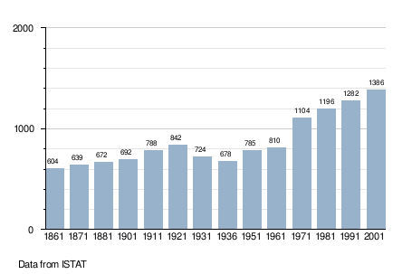
Demographic evolution
References
- ^ "Superficie di Comuni Province e Regioni italiane al 9 ottobre 2011". Italian National Institute of Statistics. Retrieved 16 March 2019.
- ^ "Popolazione Residente al 1° Gennaio 2018". Italian National Institute of Statistics. Retrieved 16 March 2019.
- ^ All demographics and other statistics: Italian statistical institute Istat.
External links
- www.comune.luvinate.va.it
- v
- t
- e
- Agra
- Albizzate
- Angera
- Arcisate
- Arsago Seprio
- Azzate
- Azzio
- Barasso
- Bardello
- Bedero Valcuvia
- Besano
- Besnate
- Besozzo
- Biandronno
- Bisuschio
- Bodio Lomnago
- Brebbia
- Bregano
- Brenta
- Brezzo di Bedero
- Brinzio
- Brissago-Valtravaglia
- Brunello
- Brusimpiano
- Buguggiate
- Busto Arsizio
- Cadegliano-Viconago
- Cadrezzate con Osmate
- Cairate
- Cantello
- Caravate
- Cardano al Campo
- Carnago
- Caronno Pertusella
- Caronno Varesino
- Casale Litta
- Casalzuigno
- Casciago
- Casorate Sempione
- Cassano Magnago
- Cassano Valcuvia
- Castellanza
- Castello Cabiaglio
- Castelseprio
- Castelveccana
- Castiglione Olona
- Castronno
- Cavaria con Premezzo
- Cazzago Brabbia
- Cislago
- Cittiglio
- Clivio
- Cocquio-Trevisago
- Comabbio
- Comerio
- Cremenaga
- Crosio della Valle
- Cuasso al Monte
- Cugliate-Fabiasco
- Cunardo
- Curiglia con Monteviasco
- Cuveglio
- Cuvio
- Daverio
- Dumenza
- Duno
- Fagnano Olona
- Ferno
- Ferrera di Varese
- Gallarate
- Galliate Lombardo
- Gavirate
- Gazzada Schianno
- Gemonio
- Gerenzano
- Germignaga
- Golasecca
- Gorla Maggiore
- Gorla Minore
- Gornate-Olona
- Grantola
- Inarzo
- Induno Olona
- Ispra
- Jerago con Orago
- Lavena Ponte Tresa
- Laveno-Mombello
- Leggiuno
- Lonate Ceppino
- Lonate Pozzolo
- Lozza
- Luino
- Luvinate
- Maccagno
- Malgesso
- Malnate
- Marchirolo
- Marnate
- Marzio
- Masciago Primo
- Mercallo
- Mesenzana
- Montegrino Valtravaglia
- Monvalle
- Morazzone
- Mornago
- Oggiona con Santo Stefano
- Olgiate Olona
- Origgio
- Orino
- Pino sulla Sponda del Lago Maggiore
- Porto Ceresio
- Porto Valtravaglia
- Rancio Valcuvia
- Ranco
- Saltrio
- Samarate
- Sangiano
- Saronno
- Sesto Calende
- Solbiate Arno
- Solbiate Olona
- Somma Lombardo
- Sumirago
- Taino
- Ternate
- Tradate
- Travedona-Monate
- Tronzano Lago Maggiore
- Uboldo
- Valganna
- Varano Borghi
- Varese
- Vedano Olona
- Veddasca
- Venegono Inferiore
- Venegono Superiore
- Vergiate
- Viggiù
- Vizzola Ticino
| Authority control databases |
|
|---|
 | This article on a location in the Province of Varese is a stub. You can help Wikipedia by expanding it. |
- v
- t
- e


