Mogoro
Comune in Sardinia, Italy
Mogoro Mòguru | |
|---|---|
Comune | |
| Comune di Mogoro | |
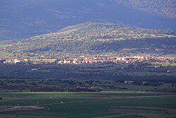 | |
Location of Mogoro  | |
39°41′N 8°47′E / 39.683°N 8.783°E / 39.683; 8.783 | |
| Country | Italy |
| Region | Sardinia |
| Province | Oristano (OR) |
| Frazioni | Morimenta |
| Government | |
| • Mayor | Sandro Broccia |
| Area | |
| • Total | 48.99 km2 (18.92 sq mi) |
| Elevation | 136 m (446 ft) |
| Population (31 October 2017)[2] | |
| • Total | 4,128 |
| • Density | 84/km2 (220/sq mi) |
| Demonym | Mogoresi |
| Time zone | UTC+1 (CET) |
| • Summer (DST) | UTC+2 (CEST) |
| Postal code | 09095 |
| Dialing code | 0783 |
| Website | Official website |
Mogoro, Mòguru in sardinian language, is a comune (municipality) in the Province of Oristano in the Italian region Sardinia, located about 60 kilometres (37 mi) northwest of Cagliari and about 30 kilometres (19 mi) southeast of Oristano.
Mogoro borders the following municipalities: Collinas, Gonnostramatza, Masullas, Pabillonis, San Nicolò d'Arcidano, Sardara, Uras. Sights include the Romanesque-Gothic church of the Carmine, built in the early 14th century and the church of Sant'Antioco.

References
Wikimedia Commons has media related to Mogoro.
- v
- t
- e
- Abbasanta
- Aidomaggiore
- Albagiara
- Ales
- Allai
- Arborea
- Ardauli
- Assolo
- Asuni
- Baradili
- Baratili San Pietro
- Baressa
- Bauladu
- Bidonì
- Bonarcado
- Boroneddu
- Bosa
- Busachi
- Cabras
- Cuglieri
- Curcuris
- Flussio
- Fordongianus
- Ghilarza
- Gonnoscodina
- Gonnosnò
- Gonnostramatza
- Laconi
- Magomadas
- Marrubiu
- Masullas
- Milis
- Modolo
- Mogorella
- Mogoro
- Montresta
- Morgongiori
- Narbolia
- Neoneli
- Norbello
- Nughedu Santa Vittoria
- Nurachi
- Nureci
- Ollastra
- Oristano
- Palmas Arborea
- Pau
- Paulilatino
- Pompu
- Riola Sardo
- Ruinas
- Sagama
- Samugheo
- San Nicolò d'Arcidano
- San Vero Milis
- Santa Giusta
- Santu Lussurgiu
- Scano di Montiferro
- Sedilo
- Seneghe
- Senis
- Sennariolo
- Siamaggiore
- Siamanna
- Siapiccia
- Simala
- Simaxis
- Sini
- Siris
- Soddì
- Solarussa
- Sorradile
- Suni
- Tadasuni
- Terralba
- Tinnura
- Tramatza
- Tresnuraghes
- Ulà Tirso
- Uras
- Usellus
- Villa Sant'Antonio
- Villa Verde
- Villanova Truschedu
- Villaurbana
- Zeddiani
- Zerfaliu

 | This Sardinia location article is a stub. You can help Wikipedia by expanding it. |
- v
- t
- e


