National Register of Historic Places listings in Clark County, South Dakota
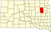
This is a list of the National Register of Historic Places listings in Clark County, South Dakota.
This is intended to be a complete list of the properties on the National Register of Historic Places in Clark County, South Dakota, United States. The locations of National Register properties for which the latitude and longitude coordinates are included below, may be seen in a map.[1]
There are 10 properties listed on the National Register in the county.
This National Park Service list is complete through NPS recent listings posted June 7, 2024.[2]
Map all coordinates using OpenStreetMap
Download coordinates as:
- KML
- GPX (all coordinates)
- GPX (primary coordinates)
- GPX (secondary coordinates)
Current listings
| [3] | Name on the Register[4] | Image | Date listed[5] | Location | City or town | Description |
|---|---|---|---|---|---|---|
| 1 | Bradley First Lutheran Church | 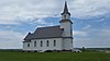 | October 12, 2000 (#00001213) | 3 miles southwest of Bradley 45°03′51″N 97°43′01″W / 45.064167°N 97.716944°W / 45.064167; -97.716944 (Bradley First Lutheran Church) | Bradley | |
| 2 | Clark Center Lutheran Church | Upload image | November 29, 2005 (#05001336) | East of the junction of 421st Ave. and 168th St. 44°57′08″N 97°47′21″W / 44.952222°N 97.789167°W / 44.952222; -97.789167 (Clark Center Lutheran Church) | Clark | |
| 3 | Clark County Courthouse |  | February 15, 2002 (#02000026) | 200 N. Commercial St. 44°52′45″N 97°44′00″W / 44.879167°N 97.733333°W / 44.879167; -97.733333 (Clark County Courthouse) | Clark | |
| 4 | Gov. S.H. Elrod House |  | July 27, 1979 (#79002399) | 301 N. Commercial St. 44°52′49″N 97°43′58″W / 44.8803°N 97.7329°W / 44.8803; -97.7329 (Gov. S.H. Elrod House) | Clark | |
| 5 | Garden City Opera House | Upload image | December 20, 1988 (#88002839) | 1st and Railroad Sts. 44°57′35″N 97°35′28″W / 44.959722°N 97.591111°W / 44.959722; -97.591111 (Garden City Opera House) | Garden City | |
| 6 | Good Hope Lutheran Church | Upload image | July 11, 2002 (#02000727) | Road 35 northwest of Vienna 44°44′49″N 97°38′13″W / 44.746944°N 97.636944°W / 44.746944; -97.636944 (Good Hope Lutheran Church) | Vienna | |
| 7 | Raymond Farmers and Citizens State Bank | Upload image | December 6, 2016 (#16000824) | 202 Flower St. 44°54′33″N 97°56′21″W / 44.909289°N 97.939168°W / 44.909289; -97.939168 (Raymond Farmers and Citizens State Bank) | Raymond | |
| 8 | Security State Bank | Upload image | May 30, 2002 (#02000577) | Garfield St. 44°37′45″N 97°38′06″W / 44.629167°N 97.635°W / 44.629167; -97.635 (Security State Bank) | Willow Lake | |
| 9 | Southeast Merton School No. 19 | Upload image | January 26, 1990 (#89002338) | North of Willow Lake 44°44′48″N 97°38′40″W / 44.746667°N 97.644444°W / 44.746667; -97.644444 (Southeast Merton School No. 19) | Willow Lake | |
| 10 | Telemarken Lutheran Church | Upload image | October 19, 1989 (#89001720) | Northwest of Wallace 45°06′00″N 97°29′40″W / 45.1°N 97.494444°W / 45.1; -97.494444 (Telemarken Lutheran Church) | Wallace |
See also
Wikimedia Commons has media related to National Register of Historic Places in Clark County, South Dakota.
- List of National Historic Landmarks in South Dakota
- National Register of Historic Places listings in South Dakota
References
- ^ The latitude and longitude information provided in this table was derived originally from the National Register Information System, which has been found to be fairly accurate for about 99% of listings. Some locations in this table may have been corrected to current GPS standards.
- ^ National Park Service, United States Department of the Interior, "National Register of Historic Places: Weekly List Actions", retrieved June 7, 2024.
- ^ Numbers represent an alphabetical ordering by significant words. Various colorings, defined here, differentiate National Historic Landmarks and historic districts from other NRHP buildings, structures, sites or objects.
- ^ "National Register Information System". National Register of Historic Places. National Park Service. April 24, 2008.
- ^ The eight-digit number below each date is the number assigned to each location in the National Register Information System database, which can be viewed by clicking the number.
- v
- t
- e

county
- Aurora
- Beadle
- Bennett
- Bon Homme
- Brookings
- Brown
- Brule
- Buffalo
- Butte
- Campbell
- Charles Mix
- Clark
- Clay
- Codington
- Corson
- Custer
- Davison
- Day
- Deuel
- Dewey
- Douglas
- Edmunds
- Fall River
- Faulk
- Grant
- Gregory
- Haakon
- Hamlin
- Hand
- Hanson
- Harding
- Hughes
- Hutchinson
- Hyde
- Jackson
- Jerauld
- Jones
- Kingsbury
- Lake
- Lawrence
- Lincoln
- Lyman
- Marshall
- McCook
- McPherson
- Meade
- Mellette
- Miner
- Minnehaha
- Moody
- Oglala Lakota
- Pennington
- Perkins
- Potter
- Roberts
- Sanborn
- Spink
- Stanley
- Sully
- Todd
- Tripp
- Turner
- Union
- Walworth
- Yankton
- Ziebach
 Category
 List
List National Register of Historic Places Portal


| |
|---|---|
| Topics | |
| Lists by state |
|
| Lists by insular areas | |
| Lists by associated state | |
| Other areas | |
| Related | |
| |


