National Register of Historic Places listings in East Baton Rouge Parish, Louisiana

This is a list of the National Register of Historic Places listings in East Baton Rouge Parish, Louisiana.
This is intended to be a complete list of the properties and districts on the National Register of Historic Places in East Baton Rouge Parish, Louisiana, United States. The locations of National Register properties and districts for which the latitude and longitude coordinates are included below, may be seen in a map.[1]
There are 90 properties and districts listed on the National Register in the parish, including 3 National Historic Landmarks. Another three properties were once listed but have been removed.
This National Park Service list is complete through NPS recent listings posted June 7, 2024.[2]
Map all coordinates using OpenStreetMap
Download coordinates as:
- KML
- GPX (all coordinates)
- GPX (primary coordinates)
- GPX (secondary coordinates)
Current listings
| [3] | Name on the Register[4] | Image | Date listed[5] | Location | City or town | Description |
|---|---|---|---|---|---|---|
| 1 | Audubon Plantation House |  | May 14, 1987 (#87000729) | 21371 Hoo Shoo Too Road 30°21′05″N 90°57′20″W / 30.35134°N 90.95549°W / 30.35134; -90.95549 (Audubon Plantation House) | Baton Rouge | |
| 2 | Baker High School Auditorium | 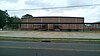 | January 29, 2014 (#13001125) | 3200 Groom Road 30°35′15″N 91°09′51″W / 30.58738°N 91.16418°W / 30.58738; -91.16418 (Baker High School Auditorium) | Baker | |
| 3 | Baker Presbyterian Church |  | March 1, 1990 (#90000346) | 3015 Groom Road 30°35′19″N 91°10′09″W / 30.58862°N 91.16913°W / 30.58862; -91.16913 (Baker Presbyterian Church) | Baker | |
| 4 | Barthel Pigeonnier | 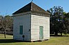 | July 13, 1983 (#83000499) | 2161 Nicholson Drive 30°25′34″N 91°11′12″W / 30.42603°N 91.1866°W / 30.42603; -91.1866 (Barthel Pigeonnier) | Baton Rouge | |
| 5 | Baton Rouge Electric Company (BRECO) Public Utilities Complex | 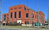 | July 13, 2017 (#100001311) | 1509 Government Street 30°26′40″N 91°10′22″W / 30.44437°N 91.1727°W / 30.44437; -91.1727 (Baton Rouge Electric Company (BRECO) Public Utilities Complex) | Baton Rouge | Also known as Gulf States Utilities (GSU) and Entergy. The 3.165 acres (1.281 ha) area comprises three contributing properties built between 1915 and 1940.[6] |
| 6 | Baton Rouge High School |  | November 6, 1986 (#86003130) | 2825 Government Street 30°26′43″N 91°09′35″W / 30.44531°N 91.15967°W / 30.44531; -91.15967 (Baton Rouge High School) | Baton Rouge | |
| 7 | Baton Rouge Junior High School |  | September 27, 1984 (#84001271) | 1100 Laurel Street 30°27′02″N 91°10′43″W / 30.45043°N 91.17869°W / 30.45043; -91.17869 (Baton Rouge Junior High School) | Baton Rouge | Also known as City Court Building. Now hosting Baton Rouge Department of Public Works.[7] |
| 8 | Baton Rouge National Cemetery |  | July 9, 1997 (#97000768) | 220 North 19th Street 30°26′58″N 91°10′03″W / 30.44941°N 91.16758°W / 30.44941; -91.16758 (Baton Rouge National Cemetery) | Baton Rouge | |
| 9 | Baton Rouge Savings and Loan Association |  | January 29, 2014 (#13001126) | 400 North Boulevard 30°26′48″N 91°11′11″W / 30.4467°N 91.18634°W / 30.4467; -91.18634 (Baton Rouge Savings and Loan Association) | Baton Rouge | |
| 10 | Baton Rouge Waterworks Company Standpipe |  | December 4, 1973 (#73002242) | 131 Lafayette Street 30°26′51″N 91°11′22″W / 30.44757°N 91.1895°W / 30.44757; -91.1895 (Baton Rouge Waterworks Company Standpipe) | Baton Rouge | |
| 11 | Beauregard Town Historic District |  | October 14, 1980 (#80001713) | Roughly bounded by North Boulevard, East Boulevard, Government Street, South 10th Street, South Boulevard, South River Road and Saint Louis Street 30°26′36″N 91°11′04″W / 30.44342°N 91.18451°W / 30.44342; -91.18451 (Beauregard Town Historic District) | Baton Rouge | |
| 12 | Belisle Building |  | October 19, 1993 (#93001104) | 344 and 350 3rd Street 30°27′00″N 91°11′17″W / 30.4501°N 91.18802°W / 30.4501; -91.18802 (Belisle Building) | Baton Rouge | |
| 13 | Borden Dairy | Upload image | March 17, 2020 (#100005100) | 4743 Florida Blvd. 30°27′03″N 91°08′30″W / 30.4508°N 91.1418°W / 30.4508; -91.1418 (Borden Dairy) | Baton Rouge | |
| 14 | Broussard House |  | July 10, 2003 (#03000616) | 4512 Highland Road 30°24′06″N 91°10′13″W / 30.4016°N 91.1704°W / 30.4016; -91.1704 (Broussard House) | Baton Rouge | |
| 15 | Campbell Apartment Building |  | June 23, 2011 (#11000398) | 528 East State Street 30°25′09″N 91°10′21″W / 30.41928°N 91.17243°W / 30.41928; -91.17243 (Campbell Apartment Building) | Baton Rouge | |
| 16 | Capital City Press Building |  | October 16, 1986 (#86002870) | 340 Florida Street 30°26′57″N 91°11′15″W / 30.44908°N 91.18745°W / 30.44908; -91.18745 (Capital City Press Building) | Baton Rouge | |
| 17 | Central Fire Station |  | April 5, 1984 (#84001277) | 427 Laurel Street 30°27′03″N 91°11′11″W / 30.4507°N 91.18651°W / 30.4507; -91.18651 (Central Fire Station) | Baton Rouge | Now hosting the Robert A. Bogan Firefighters Museum. |
| 18 | City Park Golf Course |  | December 20, 2002 (#02001546) | 1442 City Park Avenue 30°25′54″N 91°10′03″W / 30.43169°N 91.16757°W / 30.43169; -91.16757 (City Park Golf Course) | Baton Rouge | |
| 19 | Cushman House |  | February 20, 1991 (#91000072) | 1606 Main Street 30°35′30″N 91°10′01″W / 30.59164°N 91.16708°W / 30.59164; -91.16708 (Cushman House) | Baker | Now hosting the Baker Heritage Museum. |
| 20 | Downtown Baton Rouge Historic District | 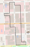 | November 10, 2009 (#09000899) | 3rd Street between Main Street and North Boulevard 30°26′58″N 91°11′18″W / 30.44932°N 91.18826°W / 30.44932; -91.18826 (Downtown Baton Rouge Historic District) | Baton Rouge | |
| 21 | Drehr Place Historic District |  | November 13, 1997 (#97001422) | Roughly bounded by Government Street, South 22nd Street, Myrtle Avenue, and Saint Rose Avenue 30°26′29″N 91°09′49″W / 30.4413°N 91.1637°W / 30.4413; -91.1637 (Drehr Place Historic District) | Baton Rouge | |
| 22 | Dufrocq School |  | March 28, 2002 (#02000268) | 330 South 19th Street 30°26′43″N 91°10′07″W / 30.4453°N 91.1687°W / 30.4453; -91.1687 (Dufrocq School) | Baton Rouge | Also known as Dufrocq Elementary School and Dufrocq Montessori Magnet Elementary School. |
| 23 | Fairhaven Plantation House | Upload image | February 11, 1988 (#88000102) | 18630 Samuel Road 30°37′45″N 91°14′00″W / 30.62921°N 91.23346°W / 30.62921; -91.23346 (Fairhaven Plantation House) | Zachary | |
| 24 | Florence Coffee House |  | January 20, 1980 (#80001714) | 130 Main Street 30°27′05″N 91°11′24″W / 30.45125°N 91.18997°W / 30.45125; -91.18997 (Florence Coffee House) | Baton Rouge | |
| 25 | The French House |  | January 13, 1982 (#82002768) | On Louisiana State University Campus, corner of South Campus Drive and Highland Road 30°24′52″N 91°10′42″W / 30.4145°N 91.17826°W / 30.4145; -91.17826 (The French House) | Baton Rouge | |
| 26 | Fuqua Hardware Store Building |  | May 12, 1999 (#99000497) | 358 3rd Street 30°27′01″N 91°11′17″W / 30.45023°N 91.18802°W / 30.45023; -91.18802 (Fuqua Hardware Store Building) | Baton Rouge | Also part of Downtown Baton Rouge Historic District since its creation on November 10, 2009.[8] |
| 27 | Hart House |  | August 1, 1980 (#80001715) | Iowa Street 30°25′35″N 91°11′10″W / 30.42651°N 91.18623°W / 30.42651; -91.18623 (Hart House) | Baton Rouge | |
| 28 | Heidelberg Hotel and Hotel King | 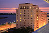 | May 20, 1982 (#82002769) | 200-201 Lafayette Street 30°26′55″N 91°11′22″W / 30.44872°N 91.18943°W / 30.44872; -91.18943 (Heidelberg Hotel and Hotel King) | Baton Rouge | |
| 29 | Highland Stockade | Upload image | March 2, 2000 (#00000191) | Address restricted[9] | Baton Rouge | |
| 30 | Kleinert Terrace Historic District |  | March 5, 1998 (#98000180) | Roughly bounded by Myrtle Avenue, Perkins Road, Broussard Avenue, and South Eugene Street 30°26′14″N 91°09′49″W / 30.43727°N 91.16354°W / 30.43727; -91.16354 (Kleinert Terrace Historic District) | Baton Rouge | |
| 31 | Kleinpeter House | Upload image | August 13, 1986 (#86001494) | 18666 Perkins Road East 30°20′40″N 91°01′19″W / 30.34435°N 91.02183°W / 30.34435; -91.02183 (Kleinpeter House) | Baton Rouge | |
| 32 | Knox Building |  | August 8, 2006 (#06000684) | 447 3rd Street 30°27′04″N 91°11′19″W / 30.45111°N 91.18852°W / 30.45111; -91.18852 (Knox Building) | Baton Rouge | Also part of Downtown Baton Rouge Historic District since its creation on November 10, 2009.[8] |
| 33 | Kress Building |  | August 10, 2006 (#06000714) | 447 3rd Street 30°27′04″N 91°11′19″W / 30.45098°N 91.18855°W / 30.45098; -91.18855 (Kress Building) | Baton Rouge | Also part of Downtown Baton Rouge Historic District since its creation on November 10, 2009.[8] |
| 34 | Kenneth C. and Carolyn B. Landry House |  | April 8, 2021 (#100006376) | 1985 Longwood Dr. 30°25′50″N 91°08′36″W / 30.4306°N 91.1432°W / 30.4306; -91.1432 (Kenneth C. and Carolyn B. Landry House) | Baton Rouge | |
| 35 | Laurel Street Fire Station |  | January 31, 2019 (#100003377) | 1801 Laurel St. 30°27′03″N 91°10′11″W / 30.4509°N 91.1698°W / 30.4509; -91.1698 (Laurel Street Fire Station) | Baton Rouge | |
| 36 | Lee Site (16 EBR 51) | Upload image | December 27, 1984 (#84000792) | Address restricted[9] | Baton Rouge | |
| 37 | Leland College | Upload image | November 10, 1982 (#82000433) | Off Groom Road, about 0.83 miles (1.34 km) west of Baker 30°35′34″N 91°10′53″W / 30.59269°N 91.18136°W / 30.59269; -91.18136 (Leland College) | Baker | |
| 38 | Les Chenes Verts | Upload image | January 21, 1993 (#92001831) | Junction of Highland Road and Jean Lafitte Avenue 30°20′51″N 91°03′48″W / 30.34757°N 91.06334°W / 30.34757; -91.06334 (Les Chenes Verts) | Baton Rouge | Also known as Live Oaks |
| 39 | Lincoln Theater |  | December 7, 2010 (#10000980) | 1305 Myrtle Walk Street 30°26′19″N 91°10′31″W / 30.43859°N 91.17523°W / 30.43859; -91.17523 (Lincoln Theater) | Baton Rouge | |
| 40 | Longwood | 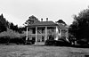 | July 7, 1983 (#83000501) | 15417 River Road 30°20′30″N 91°08′27″W / 30.34154°N 91.14092°W / 30.34154; -91.14092 (Longwood) | Baton Rouge | |
| 41 | Louisiana State Capitol Building and Gardens |  | June 9, 1978 (#78001421) | 900 North 3rd Street 30°27′25″N 91°11′14″W / 30.45704°N 91.18736°W / 30.45704; -91.18736 (Louisiana State Capitol Building and Gardens) | Baton Rouge | |
| 42 | Louisiana State University, Baton Rouge |  | September 15, 1988 (#88001586) | Highland Road; also roughly bounded by West Chime Street, West Lakeshore Drive, Raphael Semmes Drive, Highland Road, S. Campus Drive, Dorothy Dix Drive, Minnie Fisk Drive, East Parker Boulevard, South Quad Drive, West Stadium Road, and Nicholson Drive 30°24′48″N 91°10′48″W / 30.41323°N 91.18002°W / 30.41323; -91.18002 (Louisiana State University, Baton Rouge) | Baton Rouge | A boundary increase was approved April 10, 2024. |
| 43 | LSU Campus Mounds |  | March 1, 1999 (#99000236) | Along Field House Drive, on Louisiana State University Campus 30°24′54″N 91°10′56″W / 30.41506°N 91.18222°W / 30.41506; -91.18222 (LSU Campus Mounds) | Baton Rouge | |
| 44 | Magnolia Cemetery | 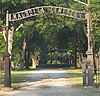 | January 31, 1985 (#85000161) | 422 North 19th Street 30°27′04″N 91°10′03″W / 30.45101°N 91.16754°W / 30.45101; -91.16754 (Magnolia Cemetery) | Baton Rouge | |
| 45 | Magnolia Mound Plantation House Dependency |  | August 9, 1977 (#77000669) | 2161 Nicholson Drive 30°25′30″N 91°11′11″W / 30.42505°N 91.18644°W / 30.42505; -91.18644 (Magnolia Mound Plantation House Dependency) | Baton Rouge | |
| 46 | Magnolia Mound Plantation House |  | September 7, 1972 (#72000549) | 2161 Nicholson Drive 30°25′35″N 91°11′14″W / 30.42627°N 91.18725°W / 30.42627; -91.18725 (Magnolia Mound Plantation House) | Baton Rouge | |
| 47 | Main Street Historic District |  | November 7, 1985 (#85002785) | Main Street between North 4th Street and North 7th Street 30°27′05″N 91°11′07″W / 30.45152°N 91.18536°W / 30.45152; -91.18536 (Main Street Historic District) | Baton Rouge | |
| 48 | Manship House | 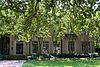 | November 21, 1980 (#80001716) | 2250 Kleinert Avenue 30°26′15″N 91°09′50″W / 30.43742°N 91.16397°W / 30.43742; -91.16397 (Manship House) | Baton Rouge | Also a contributing property to Kleinert Terrace Historic District since its creation on March 5, 1998.[10] |
| 49 | McKinley High School |  | November 16, 1981 (#81000292) | 1520 Thomas H. Delpit Drive 30°26′02″N 91°10′44″W / 30.43383°N 91.17886°W / 30.43383; -91.17886 (McKinley High School) | Baton Rouge | The present McKinley High School is located elsewhere. The historic building now is being used as the McKinley High School Alumni Center. |
| 50 | Mount Hope Plantation House | 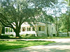 | December 3, 1980 (#80001717) | 8151 Highland Road 30°22′24″N 91°07′47″W / 30.37323°N 91.12965°W / 30.37323; -91.12965 (Mount Hope Plantation House) | Baton Rouge | |
| 51 | Nicholson School |  | January 24, 1995 (#94001585) | 1143 North Street 30°27′11″N 91°10′41″W / 30.4531°N 91.17793°W / 30.4531; -91.17793 (Nicholson School) | Baton Rouge | Now hosting Children's Charter Elementary School. |
| 52 | Old Louisiana Governor's Mansion |  | July 24, 1975 (#75000847) | 502 North Boulevard 30°26′48″N 91°11′06″W / 30.44653°N 91.18499°W / 30.44653; -91.18499 (Old Louisiana Governor's Mansion) | Baton Rouge | Also a contributing property to Beauregard Town Historic District since its creation on October 14, 1980.[11] |
| 53 | Old Louisiana State Capitol |  | January 12, 1973 (#73000862) | 100 North Boulevard 30°26′48″N 91°11′21″W / 30.44657°N 91.18903°W / 30.44657; -91.18903 (Old Louisiana State Capitol) | Baton Rouge | Built in 1847–1852 after the state legislature voted to move the seat of government from New Orleans, within 15 years the "castle" had been severely damaged during the Union Army's Civil War occupation of Baton Rouge. The statehouse was rebuilt and refurbished in the 1880s, including the addition of a stained glass dome. The legislature used the building for the next 50 years, until the current capitol tower was completed in 1932. Restored in the 1990s, the old capitol houses the state's Museum of Political History, which now has multimedia exhibits, free admission, and wheelchair-accessibility. |
| 54 | Old Post Office |  | June 9, 1980 (#80001718) | 355 North Boulevard 30°26′51″N 91°11′14″W / 30.44743°N 91.18722°W / 30.44743; -91.18722 (Old Post Office) | Baton Rouge | Now hosting Baton Rouge City Club. Also part of Downtown Baton Rouge Historic District since its creation on November 10, 2009.[8] |
| 55 | Olinde Building |  | April 28, 2014 (#13001142) | 1854 North Street 30°27′10″N 91°10′11″W / 30.45279°N 91.16974°W / 30.45279; -91.16974 (Olinde Building) | Baton Rouge | Also known as Olinde's Furniture & Appliances and Corona Building |
| 56 | Ory House | Upload image | January 21, 1993 (#92001818) | Junction of Highland Road and Jean Lafitte Avenue 30°20′51″N 91°03′46″W / 30.34759°N 91.06286°W / 30.34759; -91.06286 (Ory House) | Baton Rouge | |
| 57 | Pecue House |  | April 14, 1994 (#94000312) | 2260 Myrtle Avenue 30°26′18″N 91°09′50″W / 30.43838°N 91.16383°W / 30.43838; -91.16383 (Pecue House) | Baton Rouge | Also a contributing property to Kleinert Terrace Historic District since its creation on March 5, 1998.[10] |
| 58 | Pentagon Barracks |  | July 26, 1973 (#73000863) | Corner of State Capitol Drive and River Road 30°27′20″N 91°11′22″W / 30.45552°N 91.18933°W / 30.45552; -91.18933 (Pentagon Barracks) | Baton Rouge | Four sides of a once-five-sided structure built between 1819 & 1825 by the U. S. Army adjacent to the Mississippi River, on the site of earlier forts. Held for a time by the Confederacy during the Civil War, property of Louisiana State University in the early 20th century. Today barracks are still used by the Lieutenant Governor and state legislators. |
| 59 | Sarah Peralta Archeological Site | Upload image | March 2, 1995 (#95000134) | Address restricted[9] | Baton Rouge | |
| 60 | Joseph Petitpierre (Kleinpeter) House |  | January 23, 1986 (#86000111) | 5544 Highland Road 30°23′30″N 91°09′27″W / 30.39156°N 91.15755°W / 30.39156; -91.15755 (Joseph Petitpierre (Kleinpeter) House) | Baton Rouge | |
| 61 | Port Hudson National Cemetery |  | May 20, 1999 (#99000591) | 20978 Port Hickey Road 30°39′39″N 91°16′26″W / 30.66085°N 91.27388°W / 30.66085; -91.27388 (Port Hudson National Cemetery) | Zachary | Established to bury thousands of Union Army soldiers who fell during the longest siege in U.S. history, 1863's Siege of Port Hudson. |
| 62 | Potts House |  | September 14, 1972 (#72000550) | 831 North Street 30°27′10″N 91°10′53″W / 30.45288°N 91.18133°W / 30.45288; -91.18133 (Potts House) | Baton Rouge | Also a contributing property to Spanish Town historic district since its creation on August 31, 1978.[12] |
| 63 | Powder Magazine |  | June 4, 1973 (#73000864) | Arsenal Park, on Capitol Grounds 30°27′28″N 91°11′05″W / 30.45766°N 91.18462°W / 30.45766; -91.18462 (Powder Magazine) | Baton Rouge | Now hosting the Old Arsenal Museum. |
| 64 | Prince Hall Masonic Temple | 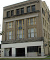 | June 2, 1994 (#94000498) | 1335 North Boulevard 30°26′52″N 91°10′32″W / 30.44786°N 91.17549°W / 30.44786; -91.17549 (Prince Hall Masonic Temple) | Baton Rouge | |
| 65 | Rabalais House |  | June 24, 2010 (#10000388) | 1300 Steele Boulevard 30°26′14″N 91°09′03″W / 30.43723°N 91.15085°W / 30.43723; -91.15085 (Rabalais House) | Baton Rouge | |
| 66 | Reiley-Reeves House |  | May 24, 1979 (#79001060) | 810 Park Boulevard 30°26′27″N 91°10′09″W / 30.44089°N 91.16924°W / 30.44089; -91.16924 (Reiley-Reeves House) | Baton Rouge | Also a contributing property to Roseland Terrace Historic District since its creation on March 11, 1982.[13] |
| 67 | Reymond House |  | June 3, 1998 (#98000663) | 7250 Goodwood Boulevard 30°26′31″N 91°06′50″W / 30.44182°N 91.11385°W / 30.44182; -91.11385 (Reymond House) | Baton Rouge | |
| 68 | Eddie Robinson Sr. Historic District | Upload image | December 18, 2018 (#100003248) | Roughly bounded by North Blvd., S 18th St., Terrace Ave. & I 110/10 30°26′23″N 91°10′22″W / 30.4398°N 91.1728°W / 30.4398; -91.1728 (Eddie Robinson Sr. Historic District) | Baton Rouge | |
| 69 | Roseland Terrace Historic District |  | March 11, 1982 (#82002770) | Bounded by Government Street, South 18th Street, Myrtle Avenue, and South 22nd Street 30°26′28″N 91°10′04″W / 30.44119°N 91.16765°W / 30.44119; -91.16765 (Roseland Terrace Historic District) | Baton Rouge | |
| 70 | Roumain Building | 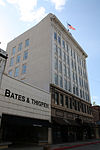 | April 11, 1985 (#85000727) | 341-343 3rd Street 30°27′00″N 91°11′19″W / 30.45003°N 91.18849°W / 30.45003; -91.18849 (Roumain Building) | Baton Rouge | Also part of Downtown Baton Rouge Historic District since its creation on November 10, 2009.[8] |
| 71 | St. James Episcopal Church |  | May 5, 1978 (#78001423) | 208 North 4th Street 30°26′55″N 91°11′12″W / 30.44848°N 91.1867°W / 30.44848; -91.1867 (St. James Episcopal Church) | Baton Rouge | |
| 72 | St. Joseph Cathedral | 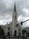 | March 22, 1990 (#90000502) | 401 Main Street 30°27′07″N 91°11′13″W / 30.45192°N 91.18694°W / 30.45192; -91.18694 (St. Joseph Cathedral) | Baton Rouge | |
| 73 | Jared Young Sanders Jr. House |  | February 14, 1997 (#97000056) | 2332 Wisteria Street 30°26′34″N 91°09′47″W / 30.44289°N 91.16315°W / 30.44289; -91.16315 (Jared Young Sanders Jr. House) | Baton Rouge | Also a contributing property to Drehr Place Historic District since its creation on November 13, 1997.[14] |
| 74 | Santa Maria Plantation House |  | December 29, 1978 (#78003448) | 19045 Perkins Road East 30°20′33″N 91°01′02″W / 30.34261°N 91.01726°W / 30.34261; -91.01726 (Santa Maria Plantation House) | Baton Rouge | |
| 75 | Scott Street School |  | July 7, 1994 (#94000681) | 900 North 19th Street 30°27′24″N 91°10′09″W / 30.45661°N 91.16929°W / 30.45661; -91.16929 (Scott Street School) | Baton Rouge | |
| 76 | John and Amelia Sharp Kleinpeter House | Upload image | October 6, 2015 (#15000693) | 7585 Willow Grove Boulevard 30°22′45″N 91°04′58″W / 30.37905°N 91.08268°W / 30.37905; -91.08268 (John and Amelia Sharp Kleinpeter House) | Baton Rouge | Also known as Willow Grove. Listing comprise a shed, a water well and a cemetery located about 300 yards (270 m) to the northwest.[15] |
| 77 | Southern University Archives Building |  | June 11, 1981 (#81000294) | Leon Netterville Drive, Southern University campus 30°31′18″N 91°11′50″W / 30.52169°N 91.19719°W / 30.52169; -91.19719 (Southern University Archives Building) | Scotlandville | Also part of Southern University Historic District since its creation on May 20, 1999.[16] |
| 78 | Southern University Historic District |  | May 20, 1999 (#99000590) | West of Leon Netterville Drive; also roughly bounded by Harding Blvd., the Mississippi River, Roosevelt Steptoe Dr. and the eastern edge of Lake Kernan, Southern University campus 30°31′23″N 91°11′52″W / 30.52318°N 91.19788°W / 30.52318; -91.19788 (Southern University Historic District) | Baton Rouge | Second set of addresses represent a boundary increase approved April 16, 2020. |
| 79 | Spanish Town |  | August 31, 1978 (#78001422) | Bounded by State Capitol Drive, North 5th Street, North 9th Street and North Street 30°27′17″N 91°11′01″W / 30.45474°N 91.18359°W / 30.45474; -91.18359 (Spanish Town) | Baton Rouge | |
| 80 | Stewart-Dougherty House |  | March 28, 1973 (#73000865) | 741 North Street 30°27′11″N 91°10′58″W / 30.45309°N 91.18279°W / 30.45309; -91.18279 (Stewart-Dougherty House) | Baton Rouge | Also a contributing property to Spanish Town historic district since its creation on August 31, 1978.[12] |
| 81 | Tessier Buildings |  | March 16, 1978 (#78001424) | 342, 346, and 348 Lafayette Street 30°27′00″N 91°11′22″W / 30.44995°N 91.18935°W / 30.44995; -91.18935 (Tessier Buildings) | Baton Rouge | Also known as Lafayette Buildings |
| 82 | U.S.S. Kidd | 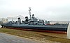 | August 9, 1983 (#83000502) | 305 South River Road 30°26′40″N 91°11′29″W / 30.44431°N 91.19151°W / 30.44431; -91.19151 (U.S.S. Kidd) | Baton Rouge | |
| 83 | US Post Office and Courthouse-Baton Rouge | 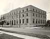 | May 18, 2000 (#00000500) | 707 Florida Avenue 30°26′59″N 91°10′59″W / 30.44978°N 91.18304°W / 30.44978; -91.18304 (US Post Office and Courthouse-Baton Rouge) | Baton Rouge | |
| 84 | Union Federal Savings and Loan Association |  | November 24, 2015 (#15000848) | 500 Laurel Street 30°27′01″N 91°11′08″W / 30.45032°N 91.18559°W / 30.45032; -91.18559 (Union Federal Savings and Loan Association) | Baton Rouge | |
| 85 | Virginia Street Historic District | Upload image | October 25, 2011 (#11000761) | 4512-4642 Virginia Street and 4338 Florida Street 30°38′51″N 91°09′22″W / 30.64746°N 91.15607°W / 30.64746; -91.15607 (Virginia Street Historic District) | Zachary | Also known as Zachary Historic Village |
| 86 | Warden's House-Old Louisiana State Penitentiary |  | December 2, 1974 (#74000921) | 701-705 Laurel Street 30°27′02″N 91°11′00″W / 30.45066°N 91.18329°W / 30.45066; -91.18329 (Warden's House-Old Louisiana State Penitentiary) | Baton Rouge | |
| 87 | Welsh-Levy Building |  | August 8, 2006 (#06000685) | 447 3rd Street 30°27′04″N 91°11′19″W / 30.45124°N 91.1885°W / 30.45124; -91.1885 (Welsh-Levy Building) | Baton Rouge | Also part of Downtown Baton Rouge Historic District since its creation on November 10, 2009.[8] |
| 88 | Fonville Winans Studio |  | August 27, 1999 (#99001052) | 409 North 7th Street 30°27′03″N 91°11′01″W / 30.45071°N 91.1836°W / 30.45071; -91.1836 (Fonville Winans Studio) | Baton Rouge | The studio of photographer Fonville Winans |
| 89 | Yazoo and Mississippi Valley Railroad Company Depot |  | May 19, 1994 (#94000463) | 100 South River Road 30°26′47″N 91°11′25″W / 30.44641°N 91.19041°W / 30.44641; -91.19041 (Yazoo and Mississippi Valley Railroad Company Depot) | Baton Rouge | |
| 90 | Zachary Railroad Depot |  | December 28, 1983 (#83003615) | 4434 West Central Avenue 30°38′53″N 91°09′25″W / 30.64812°N 91.1569°W / 30.64812; -91.1569 (Zachary Railroad Depot) | Zachary |
Former listing
| [3] | Name on the Register | Image | Date listed | Date removed | Location | City or town | Description |
|---|---|---|---|---|---|---|---|
| 1 | Adams House | Upload image | May 8, 1998 (#98000440) | June 11, 2015 | 421 North 7th Street 30°27′03″N 91°11′01″W / 30.45088°N 91.18361°W / 30.45088; -91.18361 (Adams House) | Baton Rouge | Delisted in 2015 for loss of integrity of location and setting due to move, and for several alterations to original structure.[17][18] |
| 2 | Gracelane Plantation House | Upload image | August 29, 1997 (#97000967) | January 31, 2019 | 14444 Perkins Road 30°21′44″N 91°03′29″W / 30.36226°N 91.05817°W / 30.36226; -91.05817 (Gracelane Plantation House) | Baton Rouge | Building does not exist anymore, and area is now occupied by Ruelle DeGrace Drive residential buildings. One source also report the plantation house as having been moved and delisted in 2005.[19] |
| 3 | Planter's Cabin |  | August 23, 1984 (#84001279) | November 29, 2016 | 7815 Highland Road 30°22′31″N 91°08′01″W / 30.37537°N 91.13349°W / 30.37537; -91.13349 (Planter's Cabin) | Baton Rouge | [20] |
See also
Wikimedia Commons has media related to National Register of Historic Places in East Baton Rouge Parish, Louisiana.
- List of National Historic Landmarks in Louisiana
- National Register of Historic Places listings in Louisiana
References
- ^ The latitude and longitude information provided in this table was derived originally from the National Register Information System, which has been found to be fairly accurate for about 99% of listings. Some locations in this table may have been corrected to current GPS standards.
- ^ National Park Service, United States Department of the Interior, "National Register of Historic Places: Weekly List Actions", retrieved June 7, 2024.
- ^ a b Numbers represent an alphabetical ordering by significant words. Various colorings, defined here, differentiate National Historic Landmarks and historic districts from other NRHP buildings, structures, sites or objects.
- ^ "National Register Information System". National Register of Historic Places. National Park Service. March 13, 2009.
- ^ The eight-digit number below each date is the number assigned to each location in the National Register Information System database, which can be viewed by clicking the number.
- ^ "Baton Rouge Electric Company (BRECO) Public Utilities Complex" (PDF). State of Louisiana's Division of Historic Preservation. Retrieved May 7, 2018. with 31 photos and two maps
- ^ "Baton Rouge Junior High School" (PDF). State of Louisiana's Division of Historic Preservation. Retrieved May 7, 2018. with four photos and two maps
- ^ a b c d e f "Downtown Baton Rouge Historic District" (PDF). State of Louisiana's Division of Historic Preservation. Archived from the original (PDF) on May 7, 2018. Retrieved May 7, 2018. with 23 photos and three maps Archived 2018-05-07 at the Wayback Machine
- ^ a b c Federal and state laws and practices restrict general public access to information regarding the specific location of this resource. In some cases, this is to protect archeological sites from vandalism, while in other cases it is restricted at the request of the owner. See: Knoerl, John; Miller, Diane; Shrimpton, Rebecca H. (1990), Guidelines for Restricting Information about Historic and Prehistoric Resources, National Register Bulletin, National Park Service, U.S. Department of the Interior, OCLC 20706997.
- ^ a b "Kleinert Terrace Historic District" (PDF). State of Louisiana's Division of Historic Preservation. Retrieved May 8, 2018. with three photos and two maps
- ^ "Beauregard Town Historic District" (PDF). State of Louisiana's Division of Historic Preservation. Archived from the original (PDF) on May 7, 2018. Retrieved May 11, 2018. with 22 photos and three maps Archived 2018-05-07 at the Wayback Machine
- ^ a b "Spanish Town" (PDF). State of Louisiana's Division of Historic Preservation. Retrieved May 16, 2018. with three photos and three maps
- ^ "Roseland Terrace Historic District" (PDF). State of Louisiana's Division of Historic Preservation. Retrieved May 14, 2018. with four photos and two maps
- ^ "Drehr Place Historic District" (PDF). State of Louisiana's Division of Historic Preservation. Retrieved May 8, 2018. with four photos and two maps
- ^ "John and Amelia Sharp Kleinpeter House" (PDF). State of Louisiana's Division of Historic Preservation. Retrieved May 15, 2018. with 35 photos and two maps
- ^ "Southern University Historic District" (PDF). State of Louisiana's Division of Historic Preservation. Retrieved May 15, 2018. with 18 photos and three maps
- ^ "Adams House" (PDF). State of Louisiana's Division of Historic Preservation. Retrieved May 16, 2018. with five photos and a map
- ^ "Louisiana National Register Review Committee Meeting" (PDF). April 14, 2015. p. 6.
- ^ See Louisiana Historic Preservation's National Register of Historic Places Database and also old (2002) satellite imagery on Google Earth.
- ^ "National Register of Historic Places Evaluation/Return Sheet - Removal: Planter's Cabin" (PDF). National Park Service. Retrieved May 17, 2018.
- v
- t
- e
by parish
- Acadia
- Allen
- Ascension
- Assumption
- Avoyelles
- Beauregard
- Bienville
- Bossier
- Caddo
- Calcasieu
- Caldwell
- Cameron
- Catahoula
- Claiborne
- Concordia
- DeSoto
- East Baton Rouge
- East Carroll
- East Feliciana
- Evangeline
- Franklin
- Grant
- Iberia
- Iberville
- Jackson
- Jefferson
- Jefferson Davis
- La Salle
- Lafayette
- Lafourche
- Lincoln
- Livingston
- Madison
- Morehouse
- Natchitoches
- Orleans
- Ouachita
- Plaquemines
- Pointe Coupee
- Rapides
- Red River
- Richland
- Sabine
- St. Bernard
- St. Charles
- St. Helena
- St. James
- St. John the Baptist
- St. Landry
- St. Martin
- St. Mary
- St. Tammany
- Tangipahoa
- Tensas
- Terrebonne
- Union
- Vermilion
- Vernon
- Washington
- Webster
- West Baton Rouge
- West Carroll
- West Feliciana
- Winn


