National Register of Historic Places listings in Fayette County, Tennessee

This is a list of the National Register of Historic Places listings in Fayette County, Tennessee.
This is intended to be a complete list of the properties and districts on the National Register of Historic Places in Fayette County, Tennessee, United States. Latitude and longitude coordinates are provided for many National Register properties and districts; these locations may be seen together in a map.[1]
There are 13 properties and districts listed on the National Register in the county.
Map all coordinates using OpenStreetMap
Download coordinates as:
- KML
- GPX (all coordinates)
- GPX (primary coordinates)
- GPX (secondary coordinates)
| Anderson – Bedford – Benton – Bledsoe – Blount – Bradley – Campbell – Cannon – Carroll – Carter – Cheatham – Chester – Claiborne – Clay – Cocke – Coffee – Crockett – Cumberland – Davidson – Decatur – DeKalb – Dickson – Dyer – Fayette – Fentress – Franklin – Gibson – Giles – Grainger – Greene – Grundy – Hamblen – Hamilton – Hancock – Hardeman – Hardin – Hawkins – Haywood – Henderson – Henry – Hickman – Houston – Humphreys – Jackson – Jefferson – Johnson – Knox – Lake – Lauderdale – Lawrence – Lewis – Lincoln – Loudon – Macon – Madison – Marion – Marshall – Maury – McMinn – McNairy – Meigs – Monroe – Montgomery – Moore – Morgan – Obion – Overton – Perry – Pickett – Polk – Putnam – Rhea – Roane – Robertson – Rutherford – Scott – Sequatchie – Sevier – Shelby – Smith – Stewart – Sullivan – Sumner – Tipton – Trousdale – Unicoi – Union – Van Buren – Warren – Washington – Wayne – Weakley – White – Williamson – Wilson |
This National Park Service list is complete through NPS recent listings posted June 14, 2024.[2]
Current listings
| [3] | Name on the Register[4] | Image | Date listed[5] | Location | City or town | Description |
|---|---|---|---|---|---|---|
| 1 | Bolivar-Somerville Stage Road | Upload image | August 7, 2005 (#05000802) | Herron Dr., Stewart Rd., 4.0 miles southwest of Whiteville 35°15′02″N 89°11′13″W / 35.250556°N 89.186944°W / 35.250556; -89.186944 (Bolivar-Somerville Stage Road) | Whiteville | Extends into Hardeman County |
| 2 | Crawford General Store | 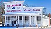 | July 8, 1975 (#75001752) | 15360 TN-193 35°09′30″N 89°22′28″W / 35.158333°N 89.374444°W / 35.158333; -89.374444 (Crawford General Store) | Williston | |
| 3 | Crawford's Experiment Farm |  | March 14, 1991 (#91000247) | 6275 Evergreen Rd. 35°09′40″N 89°22′24″W / 35.161111°N 89.373333°W / 35.161111; -89.373333 (Crawford's Experiment Farm) | Williston | |
| 4 | Immanuel Church |  | April 14, 1972 (#72001239) | 2nd and Chestnut Sts. 35°02′38″N 89°14′31″W / 35.043889°N 89.241944°W / 35.043889; -89.241944 (Immanuel Church) | La Grange | |
| 5 | La Grange Historic District |  | April 4, 1975 (#75001751) | Bounded by the La Grange town boundaries and including both sides of State Route 57 east to its junction with State Route 18 35°02′01″N 89°14′19″W / 35.033611°N 89.238611°W / 35.033611; -89.238611 (La Grange Historic District) | La Grange | |
| 6 | Lucerne | Upload image | December 23, 1977 (#77001269) | 20 miles south of Brownsville on State Route 76 35°20′48″N 89°20′30″W / 35.346667°N 89.341667°W / 35.346667; -89.341667 (Lucerne) | Brownsville | |
| 7 | Mebane-Nuckolls House | Upload image | November 20, 1985 (#85002910) | Macon-Collierville Rd. 35°08′06″N 89°32′46″W / 35.135°N 89.546111°W / 35.135; -89.546111 (Mebane-Nuckolls House) | Macon | |
| 8 | Miller House |  | December 8, 1978 (#78002587) | Raleigh-La Grange Rd. 35°06′33″N 89°34′36″W / 35.109167°N 89.576667°W / 35.109167; -89.576667 (Miller House) | Elba | |
| 9 | Oakland Presbyterian Church | Upload image | March 20, 2002 (#02000235) | 14780 State Route 194, S. 35°13′42″N 89°30′52″W / 35.228333°N 89.514444°W / 35.228333; -89.514444 (Oakland Presbyterian Church) | Oakland | |
| 10 | Petersburg Historic District | Upload image | November 7, 1985 (#85002753) | Roughly bounded by Church, Railroad, Gaunt Sts., and State Route 50 35°19′03″N 86°38′19″W / 35.3175°N 86.638611°W / 35.3175; -86.638611 (Petersburg Historic District) | Petersburg | Extends into Lincoln County |
| 11 | Rossville Historic District |  | July 19, 2001 (#01000726) | Roughly along Main, 2nd, and Front Sts. 35°02′52″N 89°32′35″W / 35.0479°N 89.5431°W / 35.0479; -89.5431 (Rossville Historic District) | Rossville | Historic downtown residences, churches, commercial buildings. |
| 12 | Somerville Historic District |  | April 15, 1982 (#82003968) | Court Square, and irregular pattern along N. Main St. 35°14′25″N 89°20′58″W / 35.240278°N 89.349444°W / 35.240278; -89.349444 (Somerville Historic District) | Somerville | |
| 13 | Williston Historic District | Upload image | December 14, 1995 (#95001409) | Roughly along Hotel and Railroad Sts. and Walker Ave. 35°09′39″N 89°22′22″W / 35.160833°N 89.372778°W / 35.160833; -89.372778 (Williston Historic District) | Williston |
See also
Wikimedia Commons has media related to National Register of Historic Places in Fayette County, Tennessee.
- List of National Historic Landmarks in Tennessee
- National Register of Historic Places listings in Tennessee
References
- ^ The latitude and longitude information provided in this table was derived originally from the National Register Information System, which has been found to be fairly accurate for about 99% of listings. Some locations in this table may have been corrected to current GPS standards.
- ^ National Park Service, United States Department of the Interior, "National Register of Historic Places: Weekly List Actions", retrieved June 14, 2024.
- ^ Numbers represent an alphabetical ordering by significant words. Various colorings, defined here, differentiate National Historic Landmarks and historic districts from other NRHP buildings, structures, sites or objects.
- ^ "National Register Information System". National Register of Historic Places. National Park Service. April 24, 2008.
- ^ The eight-digit number below each date is the number assigned to each location in the National Register Information System database, which can be viewed by clicking the number.
- v
- t
- e
- List of U.S. National Historic Landmarks by state:
- Alabama
- Alaska
- Arizona
- Arkansas
- California
- Colorado
- Connecticut
- Delaware
- Florida
- Georgia
- Hawaii
- Idaho
- Illinois
- Indiana
- Iowa
- Kansas
- Kentucky
- Louisiana
- Maine
- Maryland
- Massachusetts
- Michigan
- Minnesota
- Mississippi
- Missouri
- Montana
- Nebraska
- Nevada
- New Hampshire
- New Jersey
- New Mexico
- New York
- North Carolina
- North Dakota
- Ohio
- Oklahoma
- Oregon
- Pennsylvania
- Rhode Island
- South Carolina
- South Dakota
- Tennessee
- Texas
- Utah
- Vermont
- Virginia
- Washington
- West Virginia
- Wisconsin
- Wyoming
 National Register of Historic Places portal
 Category


