National Register of Historic Places listings in Trego County, Kansas

This is a list of the National Register of Historic Places listings in Trego County, Kansas. It is intended to be a complete list of the properties and districts on the National Register of Historic Places in Trego County, Kansas, United States. The locations of National Register properties and districts for which the latitude and longitude coordinates are included below, may be seen in an online map.
There are 8 properties and districts listed on the National Register in the county.
This National Park Service list is complete through NPS recent listings posted June 7, 2024.[1]
Current listings
Map all coordinates using OpenStreetMap
Download coordinates as:
- KML
- GPX (all coordinates)
- GPX (primary coordinates)
- GPX (secondary coordinates)
| [2] | Name on the Register[3] | Image | Date listed[4] | Location | City or town | Description |
|---|---|---|---|---|---|---|
| 1 | Collyer Downtown Historic District | 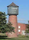 | January 7, 2010 (#09001207) | Area along Ainslie Ave., roughly bounded by 2nd St. on the north and 4th St. on the south 39°02′19″N 100°07′04″W / 39.038553°N 100.117783°W / 39.038553; -100.117783 (Collyer Downtown Historic District) | Collyer | |
| 2 | Keraus Hardware Store | Upload image | October 10, 2023 (#100009418) | 121 North Main St. 39°01′29″N 99°53′02″W / 39.02479°N 99.8840°W / 39.02479; -99.8840 (Keraus Hardware Store) | WaKeeney | |
| 3 | Lipp Barn |  | July 8, 2009 (#09000501) | 17054 130th Ave. 39°01′22″N 100°06′36″W / 39.022845°N 100.109986°W / 39.022845; -100.109986 (Lipp Barn) | Collyer | |
| 4 | St. Michael School & Convent |  | April 16, 2008 (#08000310) | 700 and 704 Ainslie Ave. 39°01′55″N 100°07′02″W / 39.031844°N 100.117342°W / 39.031844; -100.117342 (St. Michael School & Convent) | Collyer | |
| 5 | Stradal House |  | March 2, 2001 (#01000193) | 409 N. 13th St. 39°01′44″N 99°52′19″W / 39.028965°N 99.871967°W / 39.028965; -99.871967 (Stradal House) | WaKeeney | |
| 6 | Trego County Fairgrounds Exhibit Building | 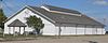 | January 28, 2004 (#03001500) | Tract 10-12-23, Trego County Fairgrounds 39°01′32″N 99°52′13″W / 39.025681°N 99.870219°W / 39.025681; -99.870219 (Trego County Fairgrounds Exhibit Building) | WaKeeney | |
| 7 | Walsh Archeological District | Upload image | January 15, 1985 (#85000091) | Address restricted | Collyer | |
| 8 | Wilcox School-District 29 |  | May 17, 2006 (#06000393) | U.S. Hwy 283 at X Rd[5] 38°47′54″N 99°53′35″W / 38.798264°N 99.89303°W / 38.798264; -99.89303 (Wilcox School-District 29) | Ransom |
See also
- List of National Historic Landmarks in Kansas
- National Register of Historic Places listings in Kansas
References
- ^ National Park Service, United States Department of the Interior, "National Register of Historic Places: Weekly List Actions", retrieved June 7, 2024.
- ^ Numbers represent an alphabetical ordering by significant words. Various colorings, defined here, differentiate National Historic Landmarks and historic districts from other NRHP buildings, structures, sites or objects.
- ^ "National Register Information System". National Register of Historic Places. National Park Service. July 9, 2010.
- ^ The eight-digit number below each date is the number assigned to each location in the National Register Information System database, which can be viewed by clicking the number.
- ^ See photo including street sign
- v
- t
- e

- Allen
- Anderson
- Atchison
- Barber
- Barton
- Bourbon
- Brown
- Butler
- Chase
- Chautauqua
- Cherokee
- Cheyenne
- Clark
- Clay
- Cloud
- Coffey
- Comanche
- Cowley
- Crawford
- Decatur
- Dickinson
- Doniphan
- Douglas
- Edwards
- Elk
- Ellis
- Ellsworth
- Finney
- Ford
- Franklin
- Geary
- Gove
- Graham
- Grant
- Gray
- Greeley
- Greenwood
- Hamilton
- Harper
- Harvey
- Haskell
- Hodgeman
- Jackson
- Jefferson
- Jewell
- Johnson
- Kearny
- Kingman
- Kiowa
- Labette
- Lane
- Leavenworth
- Lincoln
- Linn
- Logan
- Lyon
- Marion
- McPherson
- Meade
- Miami
- Mitchell
- Montgomery
- Morris
- Morton
- Nemaha
- Neosho
- Ness
- Norton
- Osage
- Osborne
- Ottawa
- Pawnee
- Phillips
- Pottawatomie
- Pratt
- Rawlins
- Reno
- Republic
- Rice
- Riley
- Rooks
- Rush
- Russell
- Saline
- Scott
- Sedgwick
- Seward
- Shawnee
- Sheridan
- Sherman
- Smith
- Stafford
- Stanton
- Stevens
- Sumner
- Thomas
- Trego
- Wabaunsee
- Wallace
- Washington
- Wichita
- Wilson
- Woodson
- Wyandotte
- Archaeological sites
- National Historic Landmarks
 Category
 NRHP portal


| |
|---|---|
| Topics | |
| Lists by state |
|
| Lists by insular areas | |
| Lists by associated state | |
| Other areas | |
| Related | |
| |

Municipalities and communities of Trego County, Kansas, United States | ||
|---|---|---|
County seat: WaKeeney | ||
| Cities |  | |
| Unincorporated communities | ||
| Ghost towns | ||
| Townships |
| |
| Footnotes | †This community is designated a Census-Designated Place (CDP) by the United States Census Bureau. | |
| ||


