Navigation Structures at Pentwater Harbor
Navigation structures in Michigan, United States
Lighthouse
43°47′N 86°26′W / 43.78°N 86.44°W / 43.78; -86.44

Navigation Structures at Pentwater Harbor

The Navigation Structures at Pentwater Harbor are navigational structures located at the west end of Lowell Street in Pentwater, Michigan. They were listed on the National Register of Historic Places in 2001.[3]
History
In 1855, Charles Mears constructed a 70-foot-wide (21 m) channel from Pentwater Lake to Lake Michigan, lined with timber cribbing,[4] to accommodate his lumbering interests.[5] In 1858, he built a pier extending over 600 feet (180 m) into Lake Michigan where ships could dock.[6] Additional pier structures were built to line the channel.[6] The first incarnation of the channel was relatively shallow, but Mears continued to improve it, and by 1865 it was deep enough that a lake-going steamer, the Daylite, was able to sail into Pentwater Lake.[4]
In 1868 the US government began widening and improving Mears's channel.[5] The channel was widened to 150 feet (46 m) and dredged to a depth of 16 feet (4.9 m).[4] Two piers were constructed, and in 1873 a timber-framed lighthouse, 33 feet (10 m) high,[4] was built on the south pier.[6] A red 6th-order Fresnel lens was installed.[4] A life-saving station was constructed on the north pier in 1887,[5] and in 1917 the pierhead light was automated.[4]
In 1937, the entire pier structure was replaced by the Army Corps of Engineers with a concrete pier.[4] At the same time, the timber-framed lighthouse was replaced with a steel skeleton structure,[6] and the optic replaced with a 12-inch (300 mm) lens.[4] Most of the life-saving station site, with the exception of the flag tower, was demolished in 1958.[5] A second light was erected on the north pier in 1997.[6]
Description
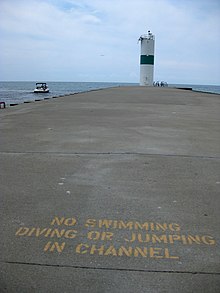
The Pentwater navigational structures consist of two concrete piers extending into Lake Michigan. At the end of the north pier sits a cylindrical modified "D9-type" tower topped with a 300-millimeter flashing green acrylic optic at a focal plane of 43 feet (13 m).[4] At the end of the south pier sits a steel skeleton tower topped with a 300-millimeter flashing acrylic optic at a focal plane of 48 feet (15 m).[4]
Further reading
- Harbor Infrastructure Inventories: Pentwater Harbor, Michigan (PDF), US Army Corps of Engineerins
References
- ^ "Pentwater Pierhead North (Lake Michigan) Light". The Weidner Publishing Group. Retrieved November 20, 2013.
- ^ "Pentwater Pierhead South (Lake Michigan) Light". The Weidner Publishing Group. Retrieved November 20, 2013.
- ^ a b "National Register Information System". National Register of Historic Places. National Park Service. July 9, 2010.
- ^ a b c d e f g h i j Pepper, Terry. "Pentwater Pierhead Light". Seeing the Light. Retrieved November 20, 2013.
- ^ a b c d "Pentwater History". Pentwater.org. Retrieved November 20, 2013.
- ^ a b c d e "History". PentwaterChannel.org. Retrieved November 20, 2013.
- v
- t
- e
- Architectural style categories
- Contributing property
- Historic district
- History of the National Register of Historic Places
- Keeper of the Register
- National Park Service
- Property types
- List of U.S. National Historic Landmarks by state:
- Alabama
- Alaska
- Arizona
- Arkansas
- California
- Colorado
- Connecticut
- Delaware
- Florida
- Georgia
- Hawaii
- Idaho
- Illinois
- Indiana
- Iowa
- Kansas
- Kentucky
- Louisiana
- Maine
- Maryland
- Massachusetts
- Michigan
- Minnesota
- Mississippi
- Missouri
- Montana
- Nebraska
- Nevada
- New Hampshire
- New Jersey
- New Mexico
- New York
- North Carolina
- North Dakota
- Ohio
- Oklahoma
- Oregon
- Pennsylvania
- Rhode Island
- South Carolina
- South Dakota
- Tennessee
- Texas
- Utah
- Vermont
- Virginia
- Washington
- West Virginia
- Wisconsin
- Wyoming
 National Register of Historic Places portal
 Category


Authority control databases | |
|---|---|
| Pentwater North Pierhead Light |
|
| Pentwater South Pierhead Light |
|


