Noirmoutier
Island off the coast of Vendée, France
46°58′N 2°13′W / 46.967°N 2.217°W / 46.967; -2.217France
Ramsar Wetland
You can help expand this article with text translated from the corresponding article in French and Spanish. (December 2009) Click [show] for important translation instructions.
- View a machine-translated version of the French article.
- Machine translation, like DeepL or Google Translate, is a useful starting point for translations, but translators must revise errors as necessary and confirm that the translation is accurate, rather than simply copy-pasting machine-translated text into the English Wikipedia.
- Do not translate text that appears unreliable or low-quality. If possible, verify the text with references provided in the foreign-language article.
- You must provide copyright attribution in the edit summary accompanying your translation by providing an interlanguage link to the source of your translation. A model attribution edit summary is
Content in this edit is translated from the existing French Wikipedia article at [[:fr:Île de Noirmoutier]]; see its history for attribution. - You may also add the template
{{Translated|fr|Île de Noirmoutier}}to the talk page. - For more guidance, see Wikipedia:Translation.
Noirmoutier (also French: Île de Noirmoutier, pronounced [nwaʁmutje]; Breton: Nervouster, Nermouster) is a tidal island off the Atlantic coast of France in the Vendée department (85).
History
Noirmoutier was the location of an early Viking raid in 799, when raiders attacked the monastery of Saint Philibert of Jumièges in 799.[2]
The Vikings established a permanent base on the island around 824, from which they could control southeast Brittany by the 840s. In 848, they sacked Bordeaux. From 862 until 882, Hastein used it as a base from which he raided Francia and Brittany.[3]
On 4 July 1674, during the Franco-Dutch war, the island was briefly captured by Dutch forces under the command of Cornelis Tromp. The Dutch flag flew from the walls on the island for nearly three weeks until, on 23 July, the Dutch abandoned it after blowing up the castle and demolishing the coastal batteries.
Noirmoutier was the site of several campaigns in the War of the Vendée, as well as a massacre [4] and the place of execution of the Royalist Generalissimo Maurice D'Elbée, who faced the firing squad seated in a chair due to wounds accumulated from an earlier battle.
St. Mary Euphrasia Pelletier was born on this island on 31 July 1796.
Geography
The island comprises ten localities and four distinct Communes of France. Its length is approximately 25 kilometres (16 mi), and its width varies from 500 metres (1,600 ft) to 15 kilometres (9.3 mi). Its area of 4,877 hectares (12,050 acres; 48.77 km2; 18.83 sq mi).
Noirmoutier is referred to as the Island of Mimosas, due to the temperateness of its climate, which allows for the flowering of Acacia dealbata (mimosa) year-round. The island is predominantly salt marsh and salt banks, sand dunes and evergreen oak forests.
The communes of the island are grouped into a communauté de communes. The communes are:
The island has been a site of uninterrupted human inhabitation since prehistoric times, and is a popular tourist destination.
Parts of the island have been reclaimed from the sea. In 2005 it served as the finish of the Tour de France prologue.
Transport
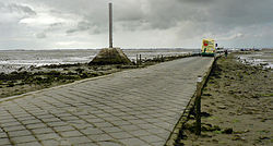
The island is most notable for the Passage du Gois, a paved-over sandbank with a length of 4.5 kilometres (2.8 mi),[5] one of the routes that connect the island to the mainland. It is flooded twice a day by the high tide. Until the early 1970s, a ferry service operated across the Strait of Fromentine between the La Fosse pier on the island and Fromentine pier on the mainland. This was superseded by the construction of the Noirmoutier Bridge, inaugurated in July 1971.
Events
Every year, an international foot race, the Foulées du Gois, is held across it, starting at the onset of the high tide.
La “Fête de la Bonnotte” (Bonnotte party) is also an annual festival celebrating the first day of potato harvest on the island of Noirmoutier.[6]
Infrastructure
In response to an effort by the French government to add offshore wind projects to the national grid, a 496 MW wind farm is being developed near the island, with a planned commissioning date of 2021.[7]
Climate
Noirmoutier experiences an oceanic climate typical of the west coast of France. Both the winters and summers are heavily moderated by the surrounding Atlantic Ocean. There is a low degree of diurnal temperature variation throughout the year, especially in the winter. There is considerably more precipitation in winter compared to summer.The clima(te is a little mediterranean (Csb) with 3 months with Tm*2>=P. More than 2300h of sun il too high for oceanic typic climate.
| Climate data for Noirmoutier Island, Vendée | |||||||||||||
|---|---|---|---|---|---|---|---|---|---|---|---|---|---|
| Month | Jan | Feb | Mar | Apr | May | Jun | Jul | Aug | Sep | Oct | Nov | Dec | Year |
| Record high °C (°F) | 16.9 (62.4) | 17.5 (63.5) | 22.9 (73.2) | 27.5 (81.5) | 31.3 (88.3) | 36.0 (96.8) | 37.0 (98.6) | 37.0 (98.6) | 33.0 (91.4) | 27.1 (80.8) | 20.5 (68.9) | 16.1 (61.0) | 37.0 (98.6) |
| Mean daily maximum °C (°F) | 9.3 (48.7) | 9.8 (49.6) | 12.5 (54.5) | 14.9 (58.8) | 18.4 (65.1) | 21.5 (70.7) | 23.4 (74.1) | 23.5 (74.3) | 21.4 (70.5) | 17.4 (63.3) | 12.9 (55.2) | 9.9 (49.8) | 16.2 (61.2) |
| Mean daily minimum °C (°F) | 4.7 (40.5) | 4.5 (40.1) | 6.4 (43.5) | 8.0 (46.4) | 11.3 (52.3) | 13.9 (57.0) | 15.7 (60.3) | 15.8 (60.4) | 13.9 (57.0) | 11.5 (52.7) | 7.7 (45.9) | 5.2 (41.4) | 9.9 (49.8) |
| Record low °C (°F) | −10.0 (14.0) | −7.7 (18.1) | −6.0 (21.2) | 0.0 (32.0) | 0.5 (32.9) | 6.0 (42.8) | 10.4 (50.7) | 9.5 (49.1) | 7.0 (44.6) | 1.7 (35.1) | −4.0 (24.8) | −8.0 (17.6) | −10.0 (14.0) |
| Average precipitation mm (inches) | 70.1 (2.76) | 56.6 (2.23) | 49.4 (1.94) | 52.1 (2.05) | 52.2 (2.06) | 34.2 (1.35) | 38.6 (1.52) | 31.5 (1.24) | 56.9 (2.24) | 85.2 (3.35) | 80.9 (3.19) | 78.4 (3.09) | 686.1 (27.02) |
| Average precipitation days | 12 | 10 | 10 | 10 | 9 | 7 | 6 | 6 | 9 | 12 | 12 | 13 | 116 |
| Mean monthly sunshine hours | 87 | 136 | 182 | 226 | 255 | 291 | 274 | 259 | 233 | 149 | 107 | 112 | 2,311 |
| Source: Météo France - Period 1981-2010 - Extremes since 1959. | |||||||||||||
References
- ^ "Marais Breton, Baie de Bourgneuf, Ile de Noirmoutier et Forêt de Monts". Ramsar Sites Information Service. Retrieved 25 April 2018.
- ^ Sawyer, Peter. "The Viking Expansion." The Cambridge History of Scandinavia, Volume 1: Prehistory to 1520. 105.
- ^ Forte, Angelo; Oram, Richard; Pedersen, Frederik (2005). Viking Empires. Cambridge: Cambridge University Press. pp. 60–62. ISBN 9780521829922.
- ^ Guillet, Rémi (September 10, 2015). Noirmoutier : Une île qui séduit. Lulu.com. p. 27. ISBN 9791090226395.
- ^ RTT, Par Claque Tes (2020-06-17). "Le passage du Gois à Noirmoutier, une route de 4 km unique en Europe". Claque tes RTT (in French). Retrieved 2022-02-15.
- ^ Spag (2017-07-12). "Fête de la Bonnotte". Spag Bertin. Retrieved 2022-02-18.
- ^ "496MW French Offshore Wind Farm Gets New Layout". Offshore Wind. 29 July 2016. Retrieved 1 August 2016.
External links
Wikimedia Commons has media related to Île de Noirmoutier.
- Tourist office website
- Google image
Authority control databases | |
|---|---|
| International |
|
| National |
|
| Geographic |
|
- v
- t
- e


