Principality of Schaumburg-Lippe
German principality (1647–1918)
County (Principality) of Schaumburg-Lippe Grafschaft (Fürstentum) Schaumburg-Lippe | |||||||||
|---|---|---|---|---|---|---|---|---|---|
| 1647–1918 | |||||||||
 Flag  Coat of arms | |||||||||
| Anthem: Heil unserm Fürsten, heil Hail to our Prince, hail! | |||||||||
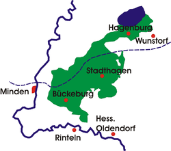
 Schaumburg-Lippe within the German Empire | |||||||||
 | |||||||||
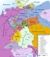
| Status | State of the Holy Roman Empire(1789-1806) State of the Confederation of the Rhine(1806-1813) State of the German Confederation(1815-1866) State of the North German Confederation(1867-1871) State of the German Empire(1871-1918) | ||||||||
| Capital | Bückeburg | ||||||||
| Government | Principality | ||||||||
| Prince | |||||||||
• 1807–1860 | George William (first) | ||||||||
• 1911–1918 | Adolf II (last) | ||||||||
| Historical era | Early modern Europe | ||||||||
• Partitioned from Schaumburg | 1647 | ||||||||
• Inherited Lippe-Alverdissen | 1777 | ||||||||
• Raised to principality | 1807 | ||||||||
• German Revolution | 1918 | ||||||||
• Merged into Lower Saxony | 1946 | ||||||||
| Population | |||||||||
• 1861 | 29,000[1] | ||||||||
| |||||||||


Schaumburg-Lippe, also called Lippe-Schaumburg, was created as a county in 1647, became a principality in 1807 and a free state in 1918, and was until 1946 a small state in Germany, located in the present day state of Lower Saxony, with its capital at Bückeburg and an area of 340 km2 (131 sq mi) and over 40,000 inhabitants.
History
Schaumburg-Lippe was formed as a county in 1647 through the division of the County of Schaumburg by treaties between the Duke of Brunswick-Lüneburg, the Landgrave of Hesse-Kassel and the Count of Lippe. The division occurred because Count Otto V of Holstein-Schaumburg had died in 1640 leaving no male heir. Initially Schaumburg-Lippe's position was somewhat precarious: it had to share a wide variety of institutions and facilities with the County of Schaumburg (which belonged to Hesse-Kassel), including the representative assembly and the highly productive Bückeberg mines, and the Landgrave of Hesse-Kassel retained some feudal rights over it. It was further threatened by the headstrong policies of the ruling Count, Frederick Christian. To counter these threats, Friedrich's grandson, Count William (who reigned 1748–1777), retained a standing army of up to 1000 troops – quite a lot for such a small territory.
With William's death in 1777, the junior Schaumburg-Lippe-Alverdissen inherited the county, thereby reuniting Schaumburg-Lippe with Lippe-Alverdissen.

Schaumburg-Lippe was a county until 1807 when it became a principality; from 1871 it was a state within the German Empire. In 1913, it was the least populous state in the German Empire.[2] The capital was Bückeburg, while Stadthagen was the only other town. Under the constitution of 1868, there was a legislative diet of 15 members with ten elected by the towns and rural districts, one each by the nobility, clergy and educated classes and the remaining two nominated by the prince. Schaumburg-Lippe sent one member to the Bundesrat (federal council) and one deputy to the Reichstag.[3] The principality lasted until the end of the German monarchies in 1918, when it became a free state as the Free State of Schaumburg-Lippe. In November 1918, Prince Adolf was the penultimate German monarch to abdicate.
Rulers of Schaumburg-Lippe


See also
Wikimedia Commons has media related to Schaumburg-Lippe.
References
- ^ A Treatise on Modern Geography, in which are Presented, Under Distinct Heads, the Natural Features, Productions, Zoology, and History of the Various Countries Throughout the World. Dublin: Congregation of the Christian Brothers. 1861. p. 121.
- ^ Herbermann, Charles, ed. (1913). "Schaumburg-Lippe" . Catholic Encyclopedia. New York: Robert Appleton Company.
- ^ Chisholm, Hugh, ed. (1911). "Schaumburg-Lippe" . Encyclopædia Britannica (11th ed.). Cambridge University Press.
- v
- t
- e


| From 1500 |
|
|---|---|
| From 1792 | |
| Status uncertain |
|
1 from 1648 2 until 1648 3 without seat in Imperial Diet ? status uncertain
Circles est. 1500: Bavarian, Swabian, Upper Rhenish, Lower Rhenish–Westphalian, Franconian, (Lower) Saxon
- Circles est. 1512: Austrian, Burgundian, Upper Saxon, Electoral Rhenish
- Unencircled territories
 States of the Confederation of the Rhine (1806–13) States of the Confederation of the Rhine (1806–13) | ||||||||
|---|---|---|---|---|---|---|---|---|
| Rank elevated by Napoleon |
|  | ||||||
| States created |
| |||||||
| Pre-existing states |
| |||||||
| ||||||||
States of the German Confederation (1815–66) | |||||||||
|---|---|---|---|---|---|---|---|---|---|
| Empires | 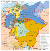 | ||||||||
| Kingdoms | |||||||||
| Electorates | |||||||||
| Grand duchies | |||||||||
| Duchies |
| ||||||||
| Principalities |
| ||||||||
| Free cities | |||||||||
| |||||||||
 States of the North German Confederation (1866–71) States of the North German Confederation (1866–71) | ||
|---|---|---|
| Kingdoms | 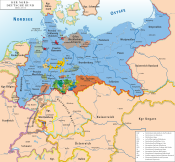 | |
| Grand Duchies | ||
| Duchies | ||
| Principalities |
| |
| City-states | ||
States of the German Empire (1871–1918) | ||
|---|---|---|
| Kingdoms |
|  |
| Grand Duchies | ||
| Duchies | ||
| Principalities |
| |
| City-states | ||
| Imperial Territories | ||
| Other | ||
Authority control databases | |
|---|---|
| International |
|
| National |
|
 | This article about government in Germany is a stub. You can help Wikipedia by expanding it. |
- v
- t
- e


