Ravenswood Manor Historic District
Historic district in Illinois, United States
United States historic place
Ravenswood Manor Historic District | |
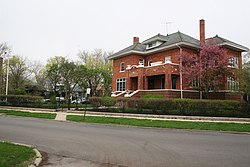 View north from the 4600 block of Manor Avenue | |
    | |
| Location | Between Sacramento Ave., N. branch of the Chicago river, and alleys S. of Lawrence Ave. and N. of Montrose Ave., Chicago, Illinois |
|---|---|
| Area | 60 acres (24 ha) |
| Architect | Harmon, William Elmer |
| Architectural style | Late 19th And 20th Century Revivals, Late 19th And Early 20th Century American Movements |
| NRHP reference No. | 08000836 [1] |
| Added to NRHP | September 05, 2008 |
The Ravenswood Manor Historic District is a historic district in the Albany Park community area of North Side, Chicago, Illinois. It is bordered by the Chicago River on the East, and by the alley south of Lawrence Avenue on the North, Sacramento Avenue on the West, and the alley North of Montrose Avenue on the south.
Ravenswood Manor is a primarily residential neighborhood that was developed during the early twentieth century. It contains many bungalows, and some of the homes along the river have their own docks.[2]
One of the most famous recent residents has been former Illinois governor Rod Blagojevich.[3]
The district was added to the National Register of Historic Places on September 5, 2008.[4]
See also
References
- ^ "National Register Information System". National Register of Historic Places. National Park Service. March 13, 2009.
- ^ Maggie Garb. "Ravenswood Manor graces riverfront". Chicago Sun-Times. August 27, 1989. Homelife, 7.
- ^ Gayle Worland. "When the governor is also the guy next door". Chicago Tribune. July 27, 2003. 1.
- ^ National Register of Historic Places Listings. September 12, 2008. Retrieved on December 15, 2009.
41°57′55″N 87°42′03″W / 41.9653°N 87.7009°W / 41.9653; -87.7009
- v
- t
- e
Chicago Landmark districts
National Register of Historic Places,
Chicago Landmark districts
- Printing House Row
- Pullman
Chicago Landmark districts
- Alta Vista Terrace
- Arlington and Roslyn Place
- Arlington-Deming
- Armitage-Halsted
- Astor Street
- Beverly/Morgan Railroad
- Bissell Street
- Burling Row House
- Calumet/Giles Prairie
- Cermak Road Bridge
- Chatham-Greater Grand Crossing Commercial
- Dover Street
- East Lake Shore Drive
- East Village
- Five Houses on Avers
- Fremont Row House
- Fulton Market
- Greenwood Row House
- Walter Burley Griffin Place
- Hawthorne Place
- Jackson Boulevard
- Jackson Park Highlands
- Jewelers Row
- Kenwood
- Longwood Drive
- McCormick Row House
- Michigan Boulevard
- Mid-North
- Milwaukee-Diversey-Kimball
- Newport Avenue
- North Kenwood
- Oakdale Avenue
- Oakland
- Old Edgebrook
- Seven Houses on Lake Shore Drive
- Surf-Pine Grove
- Terra Cotta Row
- Ukrainian Village
- Washington Park Court
- Wicker Park
| |
|---|---|
| Topics | |
| Lists by state |
|
| Lists by insular areas | |
| Lists by associated state | |
| Other areas | |
| Related | |
| |


This article about a property in Cook County, Illinois on the National Register of Historic Places is a stub. You can help Wikipedia by expanding it. |
- v
- t
- e
 | This Chicago geographical article is a stub. You can help Wikipedia by expanding it. |
- v
- t
- e


