Rien, Netherlands
Village in Friesland, Netherlands

Flag

Coat of arms
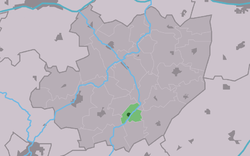
Location in the former Littenseradiel municipality
53°5′44″N 5°39′26″E / 53.09556°N 5.65722°E / 53.09556; 5.65722
 Netherlands
 Friesland
 Súdwest-Fryslân
 (2021)[1]
8641[1]
Rien is a village in Súdwest-Fryslân municipality in the province of Friesland, the Netherlands. It had a population of around 110 in January 2017.[3]
History
The village was first mentioned in 1527 as Reensterzyl, and means "water border".[4] Rien started as a satellite of Lytsewierrum near a sluice.[5]
Rien was home to 321 people in 1840. It was award village status in 1954.[5] Before 2018, the village was part of the Littenseradiel municipality and before 1984 it belonged to Hennaarderadeel municipality.[5]
Gallery
-
 Houses in Rien
 -
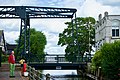 Draw bridge
 -
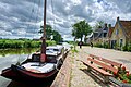 Canal of Rien


References
- ^ a b c "Kerncijfers wijken en buurten 2021". Central Bureau of Statistics. Retrieved 6 April 2022.
- ^ "Postcodetool for 8641WS". Actueel Hoogtebestand Nederland (in Dutch). Het Waterschapshuis. Retrieved 6 April 2022.
- ^ Aantal inwoners per dorp Archived 2017-04-21 at the Wayback Machine - Littenseradiel
- ^ "Rien - (geografische naam)". Etymologiebank (in Dutch). Retrieved 6 April 2022.
- ^ a b c "Rien". Plaatsengids (in Dutch). Retrieved 6 April 2022.
External links
![]() Media related to Rien, Friesland at Wikimedia Commons
Media related to Rien, Friesland at Wikimedia Commons
- v
- t
- e
Populated places in the municipality of Súdwest-Fryslân
- Abbegea
- Allingawier
- Arum
- Blauwhuis
- Boazum
- Breezanddijk
- Britswert
- Burgwerd
- Cornwerd
- Dearsum
- Dedgum
- Easterein
- Easterwierrum
- Exmorra
- Ferwoude
- Folsgare
- Gaast
- Gaastmeer
- Gauw
- Goënga
- Greonterp
- Hartwerd
- Heeg
- Hemelum
- Hichtum
- Hidaard
- Hieslum
- Hinnaard
- Hommerts
- Idsegahuizum
- Idzega
- Iens
- Indijk
- It Heidenskip
- Itens
- Jutrijp
- Kimswerd
- Kornwerderzand
- Koudum
- Koufurderrige
- Kûbaard
- Lollum
- Longerhouw
- Lytsewierrum
- Makkum
- Molkwerum
- Nijhuizum
- Nijland
- Oosthem
- Oppenhuizen
- Oudega
- Parrega
- Piaam
- Pingjum
- Poppenwier
- Reahûs
- Raerd
- Rien
- Sandfirden
- Scharl
- Scharnegoutum
- Schettens
- Schraard
- Sibrandabuorren
- Smallebrugge
- Tersoal
- Tirns
- Tjalhuizum
- Tjerkwerd
- Uitwellingerga
- Waaksens
- Warns
- Westhem
- Witmarsum
- Wiuwert
- Wolsum
- Wommels
- Wons
- Woudsend
- Ypecolsga
- Ysbrechtum
- Zurich
 | This Friesland location article is a stub. You can help Wikipedia by expanding it. |
- v
- t
- e


