Route F35 (Iceland)
You can help expand this article with text translated from the corresponding article in Icelandic. (January 2022) Click [show] for important translation instructions.
- Machine translation, like DeepL or Google Translate, is a useful starting point for translations, but translators must revise errors as necessary and confirm that the translation is accurate, rather than simply copy-pasting machine-translated text into the English Wikipedia.
- Do not translate text that appears unreliable or low-quality. If possible, verify the text with references provided in the foreign-language article.
- You must provide copyright attribution in the edit summary accompanying your translation by providing an interlanguage link to the source of your translation. A model attribution edit summary is
Content in this edit is translated from the existing Icelandic Wikipedia article at [[:is:Kjölur (fjallvegur)]]; see its history for attribution. - You may also add the template
{{Translated|is|Kjölur (fjallvegur)}}to the talk page. - For more guidance, see Wikipedia:Translation.
 | |
|---|---|
| Kjalvegur | |
 | |
| Route information | |
| Length | 168 km[1] (104 mi) |
| Major junctions | |
| Northern end |  Route 1 Hringvegur Route 1 Hringvegur |
| Southern end |  Route 35 Biskupstungnabraut Route 35 Biskupstungnabraut |
| Location | |
| Country | Iceland |
| Highway system | |
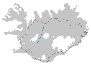
Kjalvegur (Icelandic pronunciation: [ˈcʰalˌvɛːɣʏr̥]) is a highland road in Iceland, crossing Kjölur from north to south.
History
Formerly, the name referred to a horse-track closer to Langjökull, west of the current road. This track now goes by the name Kjalvegur hinn forni (Ancient Kjalvegur), and is closed to motorized traffic.
Geography
The road begins in the south of Iceland near Haukadalur and behind the Gullfoss waterfall, ending in the north near Blönduós. The road traverses the interior between two glaciers, Langjökull and Hofsjökull. It is the second longest of the roads through the Highlands of Iceland. It takes about 5 hours to traverse by car, the road is generally rough, but river crossings are bridged.
See also
- Route 35 (Iceland)
- Sprengisandsleið
- Kjölur
- v
- t
- e
Routes through the interior highlands of Iceland
- Emstruleið (F261)
- Eyjafjarðarleið (F821)
- Fjallabaksleið nyrðri (F208)
- Fjallabaksleið syðri (F210)
- Kaldidalsvegur/Kaldidalur (550)
- Kjalvegur (F35)
- Kverkfjalaleið (F902)
- Lakagígar (F206)
- Landmannaleið (F225)
- Öskjuleið (F88)
- Öskjuvatnsvegur (F894)
- Skagafjarðarleið (F752)
- Sprengisandsleið (F26)
- Uxahryggjavegur (52)
- Vesturdalur/Hljóðaklettar (F862)

 | This article about transport in Iceland is a stub. You can help Wikipedia by expanding it. |
- v
- t
- e


