Sainte-Eulalie-de-Cernon
Commune in Occitanie, France
You can help expand this article with text translated from the corresponding article in French. (December 2008) Click [show] for important translation instructions.
- View a machine-translated version of the French article.
- Machine translation, like DeepL or Google Translate, is a useful starting point for translations, but translators must revise errors as necessary and confirm that the translation is accurate, rather than simply copy-pasting machine-translated text into the English Wikipedia.
- Do not translate text that appears unreliable or low-quality. If possible, verify the text with references provided in the foreign-language article.
- You must provide copyright attribution in the edit summary accompanying your translation by providing an interlanguage link to the source of your translation. A model attribution edit summary is
Content in this edit is translated from the existing French Wikipedia article at [[:fr:Sainte-Eulalie-de-Cernon]]; see its history for attribution. - You may also add the template
{{Translated|fr|Sainte-Eulalie-de-Cernon}}to the talk page. - For more guidance, see Wikipedia:Translation.
Commune in Occitania, France

Coat of arms
Location of Sainte-Eulalie-de-Cernon

(2020–2026) Thierry Cadenet[1]
1
(2021)[2]
12220 /12230
(avg. 635 m or 2,083 ft)
Sainte-Eulalie-de-Cernon (French pronunciation: [sɛ̃.t‿ølali də sɛʁnɔ̃]; Occitan: Senta Aulària de Sarnon) is a commune in the southern French department of Aveyron.
At the heart of the historic settlement is the Commandery of Saint Eulalia, a medieval hospital established by the Order of the Knights Templar. After that Order was disbanded by Philip IV of France in 1307-1308, royal forces were sent to close the hospital down, and from that event a detailed account of the buildings, their contents, both in the chapel and in the secular parts of the complex, and the life and customs of the occupants, has survived.[3]
The Commandery came under the control of the Knights Hospitallers during the Hundred Years War and survived until its final destruction as a result of the French Revolution towards the end of the eighteenth century.[3]
Many medieval buildings survive, together with later ones, inside high defensive walls.
-
 Entrance of the church
 -
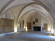 The Hall of Honour of the Commandery
 -
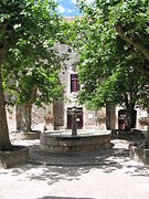 An open space within the walls


Population
| Year | Pop. | ±% |
|---|---|---|
| 1962 | 220 | — |
| 1968 | 248 | +12.7% |
| 1975 | 253 | +2.0% |
| 1982 | 230 | −9.1% |
| 1990 | 219 | −4.8% |
| 1999 | 221 | +0.9% |
| 2008 | 248 | +12.2% |
See also
Notes and references
- ^ "Répertoire national des élus: les maires" (in French). data.gouv.fr, Plateforme ouverte des données publiques françaises. 13 September 2022.
- ^ "Populations légales 2021" (in French). The National Institute of Statistics and Economic Studies. 28 December 2023.
- ^ a b Dominic Selwood, Knights of the Cloister (Boydell Press paperback, 2001), Chapter VII pp 197–207
Wikimedia Commons has media related to Sainte-Eulalie-de-Cernon.
- v
- t
- e
 Communes of the Aveyron department
- Agen-d'Aveyron
- Aguessac
- Les Albres
- Almont-les-Junies
- Alrance
- Ambeyrac
- Anglars-Saint-Félix
- Argences-en-Aubrac
- Arnac-sur-Dourdou
- Arques
- Arvieu
- Asprières
- Aubin
- Auriac-Lagast
- Auzits
- Ayssènes
- Balaguier-d'Olt
- Balaguier-sur-Rance
- Baraqueville
- Le Bas Ségala
- La Bastide-Pradines
- La Bastide-Solages
- Belcastel
- Belmont-sur-Rance
- Bertholène
- Bessuéjouls
- Boisse-Penchot
- Bor-et-Bar
- Bouillac
- Bournazel
- Boussac
- Bozouls
- Brandonnet
- Brasc
- Brommat
- Broquiès
- Brousse-le-Château
- Brusque
- Cabanès
- Calmels-et-le-Viala
- Calmont
- Camarès
- Camboulazet
- Camjac
- Campagnac
- Campouriez
- Campuac
- Canet-de-Salars
- Cantoin
- Capdenac-Gare
- La Capelle-Balaguier
- La Capelle-Bleys
- La Capelle-Bonance
- Cassagnes-Bégonhès
- Cassuéjouls
- Castanet
- Castelmary
- Castelnau-de-Mandailles
- Castelnau-Pégayrols
- Causse-et-Diège
- La Cavalerie
- Le Cayrol
- Centrès
- Clairvaux-d'Aveyron
- Le Clapier
- Colombiès
- Combret
- Compeyre
- Compolibat
- Comprégnac
- Comps-la-Grand-Ville
- Condom-d'Aubrac
- Connac
- Conques-en-Rouergue
- Cornus
- Les Costes-Gozon
- Coubisou
- Coupiac
- La Couvertoirade
- Cransac
- Creissels
- Crespin
- La Cresse
- Curan
- Curières
- Decazeville
- Druelle Balsac
- Drulhe
- Durenque
- Entraygues-sur-Truyère
- Escandolières
- Espalion
- Espeyrac
- Estaing
- Fayet
- Le Fel
- Firmi
- Flagnac
- Flavin
- Florentin-la-Capelle
- Foissac
- Fondamente
- La Fouillade
- Gabriac
- Gaillac-d'Aveyron
- Galgan
- Gissac
- Golinhac
- Goutrens
- Gramond
- L'Hospitalet-du-Larzac
- Huparlac
- Lacroix-Barrez
- Laguiole
- Laissac-Sévérac-l'Église
- Lanuéjouls
- Lapanouse-de-Cernon
- Lassouts
- Laval-Roquecezière
- Lédergues
- Lescure-Jaoul
- Lestrade-et-Thouels
- Livinhac-le-Haut
- La Loubière
- Luc-la-Primaube
- Lugan
- Lunac
- Maleville
- Manhac
- Marcillac-Vallon
- Marnhagues-et-Latour
- Martiel
- Martrin
- Mayran
- Mélagues
- Meljac
- Millausubpr
- Le Monastère
- Montagnol
- Montbazens
- Montclar
- Monteils
- Montézic
- Montfranc
- Montjaux
- Montlaur
- Montpeyroux
- Montrozier
- Montsalès
- Morlhon-le-Haut
- Mostuéjouls
- Mounes-Prohencoux
- Mouret
- Moyrazès
- Murasson
- Mur-de-Barrez
- Muret-le-Château
- Murols
- Najac
- Nant
- Naucelle
- Naussac
- Nauviale
- Le Nayrac
- Olemps
- Ols-et-Rinhodes
- Onet-le-Château
- Palmas-d'Aveyron
- Paulhe
- Peux-et-Couffouleux
- Peyreleau
- Peyrusse-le-Roc
- Pierrefiche
- Plaisance
- Pomayrols
- Pont-de-Salars
- Pousthomy
- Prades-d'Aubrac
- Prades-Salars
- Pradinas
- Prévinquières
- Privezac
- Pruines
- Quins
- Rebourguil
- Réquista
- Rieupeyroux
- Rignac
- Rivière-sur-Tarn
- Rodelle
- Rodezpref
- Roquefort-sur-Soulzon
- La Roque-Sainte-Marguerite
- La Rouquette
- Roussennac
- Rullac-Saint-Cirq
- Saint-Affrique
- Saint-Amans-des-Cots
- Saint-André-de-Najac
- Saint-André-de-Vézines
- Saint-Beaulize
- Saint-Beauzély
- Saint-Chély-d'Aubrac
- Saint-Christophe-Vallon
- Saint-Côme-d'Olt
- Sainte-Croix
- Sainte-Eulalie-de-Cernon
- Sainte-Eulalie-d'Olt
- Sainte-Juliette-sur-Viaur
- Sainte-Radegonde
- Saint-Félix-de-Lunel
- Saint-Félix-de-Sorgues
- Saint-Geniez-d'Olt-et-d'Aubrac
- Saint-Georges-de-Luzençon
- Saint-Hippolyte
- Saint-Igest
- Saint-Izaire
- Saint-Jean-d'Alcapiès
- Saint-Jean-Delnous
- Saint-Jean-du-Bruel
- Saint-Jean-et-Saint-Paul
- Saint-Juéry
- Saint-Just-sur-Viaur
- Saint-Laurent-de-Lévézou
- Saint-Laurent-d'Olt
- Saint-Léons
- Saint-Martin-de-Lenne
- Saint-Parthem
- Saint-Rémy
- Saint-Rome-de-Cernon
- Saint-Rome-de-Tarn
- Saint-Santin
- Saint-Saturnin-de-Lenne
- Saint-Sernin-sur-Rance
- Saint-Sever-du-Moustier
- Saint-Symphorien-de-Thénières
- Saint-Victor-et-Melvieu
- Salles-Courbatiès
- Salles-Curan
- Salles-la-Source
- Salmiech
- Salvagnac-Cajarc
- La Salvetat-Peyralès
- Sanvensa
- Sauclières
- Saujac
- Sauveterre-de-Rouergue
- Savignac
- Sébazac-Concourès
- Sébrazac
- Ségur
- La Selve
- Sénergues
- La Serre
- Sévérac-d'Aveyron
- Sonnac
- Soulages-Bonneval
- Sylvanès
- Tauriac-de-Camarès
- Tauriac-de-Naucelle
- Taussac
- Tayrac
- Thérondels
- Toulonjac
- Tournemire
- Trémouilles
- Le Truel
- Vabres-l'Abbaye
- Vailhourles
- Valady
- Valzergues
- Vaureilles
- Verrières
- Versols-et-Lapeyre
- Veyreau
- Vézins-de-Lévézou
- Viala-du-Pas-de-Jaux
- Viala-du-Tarn
- Le Vibal
- Villecomtal
- Villefranche-de-Panat
- Villefranche-de-Rouerguesubpr
- Villeneuve
- Vimenet
- Viviez
- pref: prefecture
- subpr: subprefecture
Authority control databases | |
|---|---|
| International |
|
| National |
|
 | This Aveyron geographical article is a stub. You can help Wikipedia by expanding it. |
- v
- t
- e


