Sonoita, Arizona
CDP in Santa Cruz County, Arizona
Census-designated place in Arizona, United States
31°40′46″N 110°39′19″W / 31.67944°N 110.65528°W / 31.67944; -110.65528[1] (2020)
85637
Sonoita (/səˈnɔɪ.tə/; O'odham: Ṣon ʼOidag) is a census-designated place (CDP) in Santa Cruz County, Arizona, United States.[1] The population was 803 at the 2020 census.[3]
The origin of the name of the CDP is the O'odham Ṣon ʼOidag, which may be best translated as "spring field".[citation needed]
Geography
Sonoita is located in northern Santa Cruz County. The community is at the intersection of Arizona State Route 83 and Arizona State Route 82. The Santa Rita Mountains and the Canelo Hills lie to the west and southwest respectively. The headwaters of Sonoita Creek are just west of the site.[4]
Historic Fort Crittenden and Fort Buchanan lie approximately four miles west of Sonoita, just north of Sonoita Creek and Route 82.[4]
According to the United States Census Bureau, the CDP has a total area of 10.5 square miles (27.3 km2), all land.[3]
Demographics
| Census | Pop. | Note | %± |
|---|---|---|---|
| 2000 | 826 | — | |
| 2010 | 818 | −1.0% | |
| 2020 | 803 | −1.8% | |
| U.S. Decennial Census[5] | |||
As of the census[6] of 2000, there were 826 people, 358 households, and 264 families residing in the CDP. The population density was 18.1 inhabitants per square mile (7.0/km2). There were 401 housing units at an average density of 8.8 per square mile (3.4/km2). The racial makeup of the CDP was 89.6% White, 0.5% Black or African American, 0.5% Native American, 0.1% Asian, 0.2% Pacific Islander, 6.5% from other races, and 2.5% from two or more races. 16.7% of the population were Hispanic or Latino of any race.
There were 358 households, out of which 20.7% had children under the age of 18 living with them, 66.2% were married couples living together, 5.9% had a female householder with no husband present, and 26.0% were non-families. 21.5% of all households were made up of individuals, and 8.4% had someone living alone who was 65 years of age or older. The average household size was 2.3 and the average family size was 2.7.
In the CDP, the population was spread out, with 18.4% under the age of 18, 2.5% from 18 to 24, 21.2% from 25 to 44, 37.7% from 45 to 64, and 20.2% who were 65 years of age or older. The median age was 50 years. For every 100 females, there were 92.5 males. For every 100 females age 18 and over, there were 90.4 males.
The median income for a household in the CDP was $51,310, and the median income for a family was $58,571. Males had a median income of $46,042 versus $26,406 for females. The per capita income for the CDP was $27,312. About 2.8% of families and 4.9% of the population were below the poverty line, including 10.1% of those under age 18 and 2.0% of those age 65 or over.
Notable residents
- Alex Flanagan, sports journalist[7]
- Mark Wystrach, musician, member of country band Midland[7]
- Rick Renzi, U.S. Congressman, owner Rainwhisper Ranch.
Images
-
 Sonoita, as seen from the main intersection in town.
 -
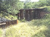 Ruins of the Fort Buchanan Bridge over Sonoita Creek
 -
 Camp (Fort) Crittenden Marker historic marker


See also
 Arizona portal

- Sonoita Creek
- Sonoita AVA, Arizona wine region around Sonoita
- Empire Ranch
- Fort Buchanan, Arizona
References
- ^ a b c d U.S. Geological Survey Geographic Names Information System: Sonoita, Arizona
- ^ "2020 U.S. Gazetteer Files". United States Census Bureau. Retrieved October 29, 2021.
- ^ a b "Explore Census Data". data.census.gov. Retrieved June 28, 2023.
- ^ a b Sonoita, Arizona, 7.5 Minute Topographic Quadrangle, USGS, 1996 (2002 rev.)
- ^ "Census of Population and Housing". Census.gov. Retrieved June 4, 2016.
- ^ "U.S. Census website". United States Census Bureau. Retrieved January 31, 2008.
- ^ a b "Catching Up with Alex Flanagan". Salpointe.org.
External links
Wikimedia Commons has media related to Sonoita, Arizona.
Wikivoyage has a travel guide for Sonoita, Arizona.
- Sonoita at Nogales-Santa Cruz County Chamber of Commerce
- Sonoita & Elgin at Patagonia Area Business Association
- Sonoita community website
- v
- t
- e
Municipalities and communities of Santa Cruz County, Arizona, United States
County seat: Nogales

places
- Arizona portal
- United States portal
Authority control databases | |
|---|---|
| International |
|
| National |
|
| Other |
|


