Tater Du Lighthouse
Lighthouse
50°03′09″N 5°34′39″W / 50.052394°N 5.577372°W / 50.052394; -5.577372Tater Du Lighthouse is Cornwall's most recently built lighthouse. The construction of the lighthouse came out of the tragedy of losing a small Spanish coaster called the Juan Ferrer on 23 October 1963, on the nearby Boscawen Point, the vessel capsized with the loss of 11 lives.[2] After the tragedy the Newlyn and Mousehole Fishermen's Association put pressure on Trinity House for a lighthouse to be built, stating that similar tragedies could happen again. The lighthouse, built with concrete blocks, was first lit in July 1965.[3]
Description
The short building is topped by a 7-foot 1 inch lantern with an electric light which is powered from batteries which are charged from mains electricity during the day. The light is 3 white lights flashed every 15 seconds, with a range of 20 nautical miles (37 km; 23 mi). There is a separate red fixed light that shows in the line over the Runnelstone Rock, shone from a lower window in the tower.
The lighthouse looks out over the Inner and Outer Bucks, two rocks that partially show at low water, and where in 1868 the SS Garonne was lost.[3]
History
Designed by Michael H. Crisp, the lighthouse was constructed with a completely automatic installation which was remotely controlled from the Trinity House depot in Penzance.[3] In 1997 the lighthouse was modernised and it is now monitored from the Trinity House Planning Centre at Harwich.[1]
In May 2022, as part of Trinity House's lighthouse modernisation programme, the revolving optic was replaced with static LED lanterns. At the same time the light's visible range was reduced from 20 nautical miles (37 km; 23 mi) to 12 nmi (22 km; 14 mi).[4]
Fog signal
The fog signal was originally a series (72 in total) of Tannoy units built into the lighthouse tower; they were powered by an alternator coupled to a 2-cylinder Ruston diesel engine.[5] This was later replaced by a short-range Pharos Marine Omnidirectional electric emitter sounding the same characteristic of two one second blasts every 30 seconds during fog.[1] The fog signal was decommissioned in 2012.[6]
Surrounding area
The coastal slope and cliffs around the lighthouse are designated the Tater–du SSSI (a Site of Special Scientific Interest) notified in 1992 because ″... it provides unique evidence of the geological history of SW England during the Variscan orogeny, in particular because of the occurrence of pillow lavas.″ The cliffs are also a Geological Conservation Review site.[7]
The nearby rocks (Inner and Outer Bucks) form a popular sub-aqua dive site.[8][9] The nearest point for launching a dive-boat is Penzance, as Lamorna Cove just around the corner from The Bucks, does not allow launching from there.
Gallery
-
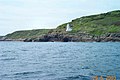
 A distant view of Tater Du Lighthouse
 -
 Tater Du Lighthouse
 -
 The coast at Tater Du
 -
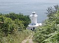 The steep access road down to the lighthouse


See also
 Cornwall portal
 Engineering portal


References
- ^ a b c "Tater Du Lighthouse". Trinity House. Retrieved 15 May 2019.
- ^ Denton, Tony; Leach, Nicholas (2007). Lighthouses of England and Wales. Ashbourne: Landmark Publishing Ltd.
- ^ a b c Noall, Cyril (1968). Cornish Lights and Shipwrecks. Truro: D. Bradford Barton.
- ^ "Notice to Mariners, 25/03/2022: 18/2022 Tater Du Lighthouse". Trinity House. Retrieved 25 October 2022.
- ^ Renton, Alan (2001). Lost Sounds: The Story of Coast Fog Signals. Caithness, Scotland: Whittles. p. 184.
- ^ "Trevose Head and Tater Du fog horns switched off". BBC News. 26 January 2012. Retrieved 4 April 2019.
- ^ "Tater-du SSSI" (PDF). Natural England. Archived from the original (PDF) on 24 October 2012. Retrieved 6 November 2011.
- ^ "Some Cornish Dive Sites". Totnes BSAC. Archived from the original on 27 February 2012. Retrieved 17 July 2012.
- ^ "Dive Sites. Mounts Bay to Lands End". UKDiving. Retrieved 17 July 2012.
External links
 Media related to Tater Du Lighthouse at Wikimedia Commons
- Tater Du Lighthouse at Trinity House
- grid reference SW440230
- Pathé footage of Tater Du lighthouse interior/exterior at the time of the official opening in 1965
- v
- t
- e
- Aire Point to Carrick Du
- Baulk Head to Mullion
- Bedruthan Steps and Park Head
- Belowda Beacon
- Boscastle to Widemouth
- Boscawen
- Bude Coast
- Caerthillian to Kennack
- Cameron Quarry
- Carn Grey Rock and Quarry
- Clicker Tor Quarry
- Cligga Head
- Coverack Cove and Dolor Point
- Coverack to Porthoustock
- Crocadon Quarry
- Crow's Nest
- Cuckoo Rock to Turbot Point
- Cudden Point to Prussia Cove
- De Lank Quarries
- Duckpool to Furzey Cove
- East Lizard Heathlands
- Folly Rocks
- Gerrans Bay to Camels Cove
- Godrevy Head to St Agnes
- Great Wheal Fortune
- Greystone Quarry
- Gwithian to Mexico Towans
- Harbour Cove
- Hawkstor Pit
- Hingston Down Quarry & Consols
- Kennack to Coverack
- Kingsand to Sandway Point
- Lidcott Mine
- Loe Pool
- Lower Fal & Helford Intertidal
- Luxulyan Quarry
- Meneage Coastal Section
- Mulberry Downs Quarry
- Mullion Cliff to Predannack Cliff
- Penberthy Croft Mine
- Penlee Point
- Penlee Quarry
- Pentire Peninsula
- Polyne Quarry
- Polyphant
- Porthcew
- Porthleven Cliffs
- Porthleven Cliffs East
- Rame Head & Whitsand Bay
- Roche Rock
- Rock Dunes
- Rosemullion
- Rosenun Lane
- South Terras Mine
- St Agnes Beacon Pits
- St Erth Sand Pits
- St Mewan Beacon
- St Michael's Mount
- Stepper Point
- Stourscombe Quarry
- Swanpool
- Tater-du
- Tintagel Cliffs
- Trebetherick Point
- Tregargus Quarries
- Trelavour Downs
- Tremearne Par
- Trevaunance Cove
- Trevone Bay
- Trevose Head and Constantine Bay
- Viverdon Quarry
- West Lizard
- Wheal Alfred
- Wheal Gorland
- Wheal Martyn
- Wheal Penrose
- Yeolmbridge Quarry
- Castle Down (Tresco)
- Chapel Down (St. Martin's)
- Peninnis Head (St. Mary's)
- Porth Seal (St. Martin's)
- Porthloo
- Shipman Head & Shipman Down (Bryher)
- St Martin's Sedimentary Shore
- Teän
- Watermill Cove
- White Island

| Authority control databases: Geographic |
|
|---|


