Temple Butte
Landform in the Grand Canyon, Arizona


Temple_Butte
Location in Arizona (confluence of the Little Colorado and Colorado rivers)
Supai Group,
Redwall Limestone,
(Tonto Group-(3 units)),
3_Muav Limestone,
2_Bright Angel Shale,
1_Tapeats Sandstone
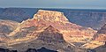
Temple Butte, in the Grand Canyon, Arizona, US is a prominence below the East Rim. The butte lies on the west bank of the south-flowing Colorado River. The outfall from the Little Colorado River, draining from the Painted Desert to the east and southeast, is about two miles upstream.
Temple Butte is 5,308 feet (1,618 m) in elevation. It is the historical site of some wreckage of the 1956 Grand Canyon mid-air collision. It was first thought that smoke from Temple Butte, was due to a lightning strike fire, but later was found to be the result of the mid-air collision.

A closer view of Chuar and Temple Buttes.
Trails
The Tanner Trail from Desert View, Arizona down to the Colorado River, follows the west ridgeline of Tanner Canyon, and has numerous views looking due-north to Temple Butte. The trail ends at a viewpoint on the upper surfaces of a Redwall Limestone ridge. The Redwall Limestone is seen prominently below the East Rim, and is the cliff-forming shelf upon which the redbeds of the Supai Group accumulate.
Geology
The prominence of Temple Butte is composed of the upper unit of the Supai Group, ("redbeds"), the cliff-former, Esplanade Sandstone. The entire prominence is a much eroded, cliff remainder of the Esplanade, but the four units of the Supai Group, are compact, in an approximate north-south direction, with a large-pyramid-shape at the north, a pointed-pyramid at the south, and an eroded saddle in between.
The Supai Group sits on the platform, upper surface of the Redwall Limestone, on Cambrian rock units below. Another upper platform of the cliff-forming Muav Limestone, underlies the Redwall. (It is a double-platform rock unit.) The slopes of colorful Bright Angel Shale are below. And below that are the short cliffs of Tapeats Sandstone, (typically bordering gorges and the Colorado River), famous for making the Tonto Platform, above the 1,000-million year old Great Unconformity of lost time, and eroded rock units.
The east strike (section) of the Butte Fault is on the west side of Temple Butte. The west section of the Butte Fault is the East Kaibab Monocline. The Butte Fault sections are north-south trending, and are part of the uplift of the Kaibab Plateau.

Access
Desert View is the closest paved route site to Temple Butte viewpoints. It is located on the East Rim, and is about 20 mi (32 km) east of Grand Canyon Village, on the East Rim Road, (Arizona State Route 64). Desert View is also 32 mi (51 km) west of U.S. 89, by way of Arizona 64.
Observation viewpoints
Temple Butte can be viewed from the south at East Rim, Grand Canyon viewpoints in the vicinity of Desert View, Arizona. Lipan Point, Desert View Point, and to the south Hollenback Point have views due-north into the Grand Canyon. About 5 mi (8.0 km) north of Desert View Point by unimproved road, or hiking is Comanche Point, a distance of 5-mi south-southeast of Temple Butte.
An unimproved route, going north from Desert View, about 12 to 14 mi long ends at Cape Solitude; the point is adjacent the south canyon outfall of the Little Colorado River and canyon, with the Colorado River. Temple Butte is 2.5 mi (4.0 km) west.[5]
Gallery
-

-
 (aerial view)-Chuar Lava Hill,
Temple Butte,
Chuar Butte -
 Chuar and
Temple Buttes -
 Temple Butte,
(north aspect) and
(east aspect)
Chuar Butte (east aspect) - A partial west
aspect of Temple
Butte.
shows Redwall on short
Muav Limestone cliff,
on Bright Angel Shale,
on Tapeats Sandstone
lining on the gorge edges


References
- ^ a b c d e "Temple Butte – 5,308' AZ". Lists of John. Retrieved January 2, 2021.
- ^ "Temple Butte". Geographic Names Information System. United States Geological Survey, United States Department of the Interior. Retrieved 2021-01-02.
- ^ Arizona Road & Recreation Atlas, Benchmark Maps, p. 29.
- ^ Arizona Road & Recreation Atlas, p. 29.
- ^ Arizona DeLorme Atlas & Gazetteer, p. 32.
- Arizona Road & Recreation Atlas, Benchmark Maps, 2nd Edition, c. 1998, 112 pages, pp. 28–29, 62–63.
- Arizona DeLorme Atlas & Gazetteer, 5th Edition, c. 2002, 76 pages, pp. 32, 24.
External links
Wikimedia Commons has media related to Temple Butte.
Wikimedia Commons has media related to Toroweap Formation.
Wikimedia Commons has media related to Coconino Sandstone.
Wikimedia Commons has media related to Supai Group.
- Temple Butte, Eastern Grand Canyon, at Little Colorado River, (lat-long.com), coordinates, Coconino County, AZ
- v
- t
- e
(Yavapai County)
- Boundary Cone
- Fortification Hill
- Mount Wilson
- Mount Union
- Castle Dome
- Carr Peak
- Miller Peak
- Aubrey Peak
- Hualapai Peak
- Lime Peak
- Mae West Peaks
- Four Peaks
- Mount Ord
- East End
- McDowell Peak
- Mount McDowell
- Thompson Peak
- Mount Ballard (Arizona)
- Camelback Mountain
- Mummy Mountain
- Piestewa Peak
- South Mountains
- Sunnyslope Mountain
- Ibex Peak
- Agassiz Peak
- Doyle Peak
- Fremont Peak
- Mount Bigelow
- Mount Lemmon
- Pusch Ridge
- Thimble Peak
- Mount Hopkins
- Mount Wrightson
- Mount Turnbull
- Mistake Peak
- Granite Mountain
- Black Dome
- Sentinel Peak
- Tumamoc Hill
- Apache Peak
- Black Mesa (Navajo County)
- Escudilla Mountain
- Mount Baldy
- Agathla Peak
- Agua Caliente Mountains
- Agua Dulce Mountains
- Antelope Hill
- Aquarius Mountains
- Artillery Mountains
- Atascosa Mountains
- Aubrey Hills
- Baboquivari Peak
- Balakai Mesa
- Beaver Dam Mountains
- Belmont Mountains
- Bill Williams Mountain
- Bitsihuitsos Butte
- Black Hills (Greenlee County)
- Black Mesa (Apache-Navajo Counties)
- Black Mesa (Warm Springs)
- Black Mountain (Maricopa County)
- Black Mountain (Pima County)
- Blackjack Mountains
- Bryan Mountains
- Buckskin Mountain (Arizona-Utah)
- Buckskin Mountains (La Paz County)
- Bush Head
- Cabeza Prieta Mountains
- Canelo Hills
- Carrizo Mountains
- Cerro Colorado Mountains
- Chocolate Mountains
- Copper Mountains
- Coyote Mountains
- Date Creek Mountains
- Dome Rock Mountains
- Dos Cabezas Mountains
- Etoi Ki
- Excalibur
- Galiuro Mountains
- Gavilan Peak
- Gila Bend Mountains
- Gila Mountains (Graham County)
- Gila Mountains (Yuma County)
- Goldfield Mountains
- Grand Wash Cliffs
- Granite Mountains
- Granite Wash Mountains
- Growler Mountains
- Gu Achi Peak
- Guadalupe Mountains
- Harcuvar Mountains
- Harquahala Mountains
- House Mountain
- Hunts Mesa
- Isis Temple
- John the Baptist Mountains
- Juniper Mesa
- Kaibab Plateau
- Kofa Mountains
- Laguna Mountains
- Las Guijas Mountains
- Lime Mountain (Maricopa County}
- Little Harquahala Mountains
- Little Rincon Mountains
- Lukachukai Mountains
- Madrean Sky Islands
- Mescal Mountains
- Mineral Mountains
- Moccasin Mountains
- Mohave Mountains
- Mohawk Mountains
- Mount Trumbull
- Muggins Mountains
- Mustang Mountains
- Navajo Mountain
- The Needles
- New River Mountains
- New Water Mountains
- Newton Butte
- Painted Rock Mountains
- Pajarito Mountains
- Patagonia Mountains
- Peacock Mountains
- Picacho Peak
- Picketpost Mountain
- Pinnacle Peak
- Poachie Range
- Poston Butte
- Rawhide Mountains
- Sacaton Mountains
- San Luis Mountains
- Santa Maria Mountains
- Sevenmile Mountains
- Sierra San Antonio
- Sierra Estrella
- Sierra Madre Occidental
- Sierra Pinta
- Silver Bell Mountains
- Squaw Tits
- Sugarloaf Mountain
- Sunset Mountains
- Swisshelm Mountains
- Tempe Butte
- Temple Butte
- Tinajas Altas Mountains
- Tordillo Mountain
- Tortolita Mountains
- Trigo Mountains
- Tule Mountains
- Tumacacori Mountains
- Virgin Mountains
- Vulcan's Throne
- Vulture Mountains
- Waterman Mountains
- Weaver Mountains
- West Silver Bell Mountains
- White Tank Mountains
- Wickenburg Mountains


