Teramachi Street
Street in Kyoto, Japan
You can help expand this article with text translated from the corresponding article in Japanese. (September 2011) Click [show] for important translation instructions.
- View a machine-translated version of the Japanese article.
- Machine translation, like DeepL or Google Translate, is a useful starting point for translations, but translators must revise errors as necessary and confirm that the translation is accurate, rather than simply copy-pasting machine-translated text into the English Wikipedia.
- Do not translate text that appears unreliable or low-quality. If possible, verify the text with references provided in the foreign-language article.
- You must provide copyright attribution in the edit summary accompanying your translation by providing an interlanguage link to the source of your translation. A model attribution edit summary is
Content in this edit is translated from the existing Japanese Wikipedia article at [[:ja:寺町通]]; see its history for attribution. - You may also add the template
{{Translated|ja|寺町通}}to the talk page. - For more guidance, see Wikipedia:Translation.
Teramachi Street (寺町通 てらまちどおり, teramachidōri) is a historical street in Kyoto, Japan, running north–south from Kuramaguchi Street to Gojō Street, for about 4.6 km.[1]
History
Present day Teramachi Street corresponds to the Higashi Kyōgoku Ōji of the Heian-kyō.[1] At the time the Street was about 32 meters wide but later it was destroyed due to the Ōnin War.[2]
In the year 1590 the street was reconstructed by Toyotomi Hideyoshi, who ordered a large number of Buddhist temples to be moved to the site. According to records, there were approximately 80 temples in the area, from different sects.[2]
The street's name literally means "Temple Town", similar to English "Templeton", and reflects the large number of temples moved there during Toyotomi Hideyoshi's remodeling of Kyoto in the 16th century.
It is said that by lining up the temples, Toyotomi Hideyoshi actually wanted to protect the city from attacks coming from the east, as invaders would run into the sacred buildings first, making it hard for them to proceed with their plans and destroy the city.[3]
During the Edo period, stores selling books, Buddhist rosaries, writing brushes and medicines began to flourish in the area; as well as the shops of paper and shamisen craftsmen, which eventually gave shape to the street of today.[2]
From 1895 to 1926, there was a tram running between Marutamachi Street and Nijō Street.[4]
Present Day
Nowadays the street runs on the east side of the Kyoto Imperial Palace, between Kawaramachi Street (east side) and Gokomachi Street (west side).[1]
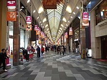
The section extending from Marutamachi Street to Nijō Street is known as Teramachikai and is lined with antique stores and galleries. The section from Oike Street to Sanjō Street is a shopping arcade called Teramachi Shōtengai.[1]
The area extending from Sanjō Street to Shijō Street is also an arcade containing an assortment of shops and services, both traditional and modern, which receives the name of Teramachi Kyōgoku Shōtengai (Compasso Teramachi).[1]
The section between Oike Street and Shijō Street is closed to vehicular traffic during the day and along with the shopping streets Kawaramachi and Shinkyōgoku forms a pedestrian passage,[1] which is currently a popular shopping spot in the city among young people and tourists as well.[5][3]
The section between Shijō Street and Takatsuji Street has many electronic shops, receiving the name of "Teramachi Denkigai".[1]
Relevant Landmarks Along the Street[1]
- Yatadera
- Rozan-ji
- Honnō-ji
- Kyoto Imperial Palace
- Kyoto City Library of Historical Documents
- Kyoto City Hall
References
- ^ a b c d e f g h "寺町通 京都通百科事典". 京都通百科事典 (in Japanese). Retrieved 2020-09-09.
- ^ a b c "寺町の歴史 | 京都 寺町京極商店街". www.kyoto-teramachi.or.jp (in Japanese). 2020-02-22. Retrieved 2020-10-01.
- ^ a b "京都・寺町通りのナゾ。なぜ秀吉は、京の東部に寺を並べたのか?". まぐまぐニュース! (in Japanese). 2017-02-03. Retrieved 2020-10-01.
- ^ "歴史・史跡・名所 | 商店街振興組合寺町会" (in Japanese). Retrieved 2020-10-01.
- ^ "京のいっぴん物語: 第172回 歴史と魅力が詰まった商店街 寺町・新京極". www.kbs-kyoto.co.jp. Retrieved 2020-09-09.
External links
Wikimedia Commons has media related to Teramachi-dori (Kyoto).
- Yatadera
- Kyoto Imperial Palace
- Kyoto City Library of Historical Documents
- Teramachikai English website
35°0′23″N 135°46′0.8″E / 35.00639°N 135.766889°E / 35.00639; 135.766889
- v
- t
- e


