The Olde Ship
Historic site in Lancashire, England
53°55′44″N 2°54′40″W / 53.92898°N 2.91109°W / 53.92898; -2.91109 Listed Building – Grade II


Location of The Olde Ship in the Borough of Wyre
Show map of the Borough of Wyre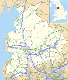
The Olde Ship (Lancashire)
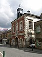
Show map of LancashireThe Olde Ship is an historic building in Pilling, Lancashire, England. It was built in 1782 for sea captain and slave trader[1] George Dickinson (1732–1806),[2] and has been designated a Grade II listed building by Historic England.[3][4]
The building was used as a farmhouse, owned by a Mr Whiteside, in 1815,[5] while William Armer was landlord, when the property was a public house, for 36 years, retiring in 1927 at the age of 68.[6]
The village smithy adjoined the inn. It is now a private residence.[1]
See also
Notes
- ^ a b A History of Blackpool, the Fylde and South Wyre – Nick Moore (2018), p. 211
- ^ The Old Ship, Pilling – Geograph.co.uk
- ^ Hartwell & Pevsner (2009), p. 503
- ^ Historic England & 1361882
- ^ General View of the Agriculture of Lancashire, Board of Agriculture (Great Britain), R. W. Dickson, William Stevenson (1815), p. 587
- ^ William Armer & Mary Bailey – The Armers of Lancashire, 4 May 2017
Sources
- Hartwell, Clare; Pevsner, Nikolaus (2009) [1969], Lancashire: North, The Buildings of England, New Haven and London: Yale University Press, ISBN 978-0-300-12667-9
- Historic England, "The Old Ship, Pilling (1361882)", National Heritage List for England, retrieved 8 December 2015
External links
- A view of the building in 2017
- A 19th-century view of the building
- v
- t
- e
Buildings and structures in the Borough of Wyre
| Places of worship |
|
|---|


| |
| Places of worship |
|
|---|---|
| |
| Places of worship |
|
|---|---|
| Places of worship | |
|---|---|
demolished
- Barnacre-with-Bonds
- Bleasdale
- Cabus
- Catterall
- Claughton
- Fleetwood
- Forton
- Garstang
- Great Eccleston
- Hambleton
- Inskip-with-Sowerby
- Kirkland
- Myerscough & Bilsborrow
- Nateby
- Nether Wyresdale
- Out Rawcliffe
- Pilling
- Poulton-le-Fylde
- Preesall
- Stalmine-with-Staynall
- Thornton-Cleveleys
- Upper Rawcliffe-with-Tarnacre
- Winmarleigh
 | This pub-related article is a stub. You can help Wikipedia by expanding it. |
- v
- t
- e


