Vera Cruz, Missouri
Unincorporated community in the American state of Missouri
Community in Missouri, U. S. A.
36°54′50″N 92°29′37″W / 36.91389°N 92.49361°W / 36.91389; -92.49361[1][2]Vera Cruz is an unincorporated community in central Douglas County, Missouri, United States.[2] It is located on Bryant Creek, approximately 9 miles (14 km) east of Ava, at the terminus of Route AB.[1][3]
History
Vera Cruz was established in the 1840s and named for Vera Cruz in Mexico.[4] The village was originally called Red Bud and was at the junction of the Rockbridge–Hartville road, up Bryant valley with the Old Salt Road or Rockbridge Road, which ran northwest through Smallett to Springfield.[5] The name was changed to Vera Cruz in 1859. It was the first county seat of Douglas County.[4] In 1870, the county seat was moved to Arno and shortly after to Ava.[6]
The Civil War battle Battle of Clark's Mill on November 7, 1862, took place at a mill on Bryant Creek, approximately one mile (1.6 km) north of the current location.[5][7] A second battle occurred on November 3, 1864, near Wilson's Mill, during which the Confederate forces were driven out of the area.[5]
Gallery
-
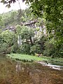 Hunter Creek bluff above the old mill pond at Vera Cruz, Missouri
 -
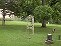 The cemetery in Vera Cruz, Missouri


References
- ^ a b Brushyknob, Missouri, 7.5 Minute Topographic Quadrangle, USGS, 1973
- ^ a b c U.S. Geological Survey Geographic Names Information System: Vera Cruz, Missouri
- ^ Ava, Missouri, 30x60 Minute Topographic Quad, USGS, 1985
- ^ a b Moser, Arthur Paul; A Directory of Towns, Villages, and Hamlets Past and Present of Douglas County, Missouri
- ^ a b c Vinyard, J. C., The Battles of Vera Cruz, Nov. 7 1862 — Nov. 3, 1864, Douglas County Historical Society Journal, May, 1994, pp 18–21
- ^ Earngey, Bill (1995). Missouri Roadsides: The Traveler's Companion. University of Missouri Press. pp. 11–12. ISBN 0-8262-1021-X.
- ^
- U.S. National Park Service CWSAC Battle Summary Archived September 24, 2008, at the Wayback Machine
- The Battle of Clark's Mill, Watersheds.org
- v
- t
- e
Municipalities and communities of Douglas County, Missouri, United States
County seat: Ava

- Benton
- Boone
- Brown
- Brush Creek
- Bryan
- Buchanan
- Campbell
- Cass
- Champion
- Clay
- Clinton
- Findley
- Jackson
- Lincoln
- McKinley
- McMurtrey
- Miller
- Richland
- Spencer
- Spring Creek
- Walls
- Washington
- Wood
communities
- Arden
- Arno
- Basher
- Bertha
- Blanche
- Brushyknob
- Buckhart
- Champion
- Cheney
- Coldspring
- Cross Roads
- Denlow
- Depew
- Dogwood
- Drury
- Fielden
- Filer
- Gentryville
- Girdner
- Goodhope
- Granada
- Hebron
- Hest
- Merritt
- Olathia
- Ongo
- Pansy
- Prior
- Red Bank
- Richville
- Rome
- Roosevelt
- Roy
- Smallett
- Squires
- Sweden
- Tigris
- Topaz
- Vanzant
- Vera Cruz
- Witty
- Missouri portal
- United States portal
 | This Douglas County, Missouri state location article is a stub. You can help Wikipedia by expanding it. |
- v
- t
- e


