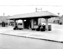
Ground-level view of Westlake Square streetcar stop as it appeared when built in 1917Underground comfort station interior in 1917
Westlake Square is a 0.01-acre (0.0040 ha) park in Seattle, Washington,[1] adjacent to Westin Seattle. It was formerly a combination streetcar stop and underground comfort station.[2] The former comfort station was demolished and filled in 1964.[2][3]
In 2010, Seattle Department of Transportation redeveloped Westlake Square and adjacent McGraw Square into a new plaza for the South Lake Union Streetcar.[4][5]
See also
Westlake Park, a larger park nearby
Westlake Station, in the nearby underground transit tunnel
McGraw Square, a plaza located one block south on Westlake Avenue
References
^Westlake Square, Seattle Parks and Recreation, retrieved 2013-12-29
^ ab"Item 30694: Westlake Square, underground men's restroom demolished and filled in 1964", Municipal archives photo collection—Don Sherwood Parks History Collection, Seattle Office of the City Clerk, retrieved 2017-10-04. Annotated photo from September 18, 1917.
^"Item 1447: Comfort Station Westlake and Stewart", Municipal archives photo collection—Engineering Department Photographic Negatives, Seattle Office of the City Clerk, Sep 18, 1917
^Westlake Transportation Hub Strategy draft recommendations(PDF), Seattle Department of Transportation, retrieved 2013-12-30
^Westlake Streetcar Plaza/McGraw Square: City Opens New McGraw Square, Seattle Department of Transportation, February 9, 2011, retrieved 2013-12-30
External links
Wikimedia Commons has media related to Westlake Square.


 Category


