Al-Mansura, Safad
- Lihat El Mansurah (disambiguasi) untuk situs lainnya dengan nama serupa.
Al-Mansura المنصوره | |
|---|---|
Village | |
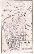 Al-Mansura (Mansoura) ditandai pada peta John MacGregor. Januari 1869. | |
| Etimologi: Tempat Mansûr[1] | |
| 33°12′59″N 35°38′26″E / 33.21639°N 35.64056°E / 33.21639; 35.64056Koordinat: 33°12′59″N 35°38′26″E / 33.21639°N 35.64056°E / 33.21639; 35.64056 | |
| Grid Palestina | 210/291 |
| Entitas geopolitik | Mandat Palestina |
| Subdistrik | Safad |
| Tanggal pengosongan | 25 Mei 1948[3] |
| Populasi (1945) | |
| • Total | 360[2] |
| Wilayah saat ini | She'ar Yashuv[4] |
Al-Mansura (Arab: المنصوره) adalah sebuah desa Arab Palestina di Subdistrik Safad. Desa tersebut berjarak 31 kilometer (19 mi) dari timur laut Safad di Sungai Banyas, sampai selatan wilayah yang sekarang disebut Dafna.
Lihat pula
- Mallaha
- Al-Salihiyya
Referensi
Daftar pustaka
- Assis, Royee (2017-09-11). "She'ar Yashuv" (129). Hadashot Arkheologiyot – Excavations and Surveys in Israel.
- Barron, J.B., ed. (1923). Palestine: Report and General Abstracts of the Census of 1922. Government of Palestine.
- Conder, C.R.; Kitchener, H.H. (1881). The Survey of Western Palestine: Memoirs of the Topography, Orography, Hydrography, and Archaeology. 1. London: Committee of the Palestine Exploration Fund.
- Government of Palestine, Department of Statistics (1945). Village Statistics, April, 1945.
- Hadawi, S. (1970). Village Statistics of 1945: A Classification of Land and Area ownership in Palestine. Palestine Liberation Organization Research Center. Diarsipkan dari versi asli tanggal 2018-12-08. Diakses tanggal 2009-08-18. Parameter
|url-status=yang tidak diketahui akan diabaikan (bantuan) - Khalidi, W. (1992). All That Remains: The Palestinian Villages Occupied and Depopulated by Israel in 1948. Washington D.C.: Institute for Palestine Studies. ISBN 0-88728-224-5.
- Macgregor, J. (1869). The Rob Roy on the Jordan: Nile, Red Sea, & Gennesareth, Etc. : a Canoe Cruise in Palestine and Egypt and the Waters of Damascus. London: John Murray.
- Mills, E., ed. (1932). Census of Palestine 1931. Population of Villages, Towns and Administrative Areas. Jerusalem: Government of Palestine.
- Morris, B. (2004). The Birth of the Palestinian Refugee Problem Revisited. Cambridge University Press. ISBN 978-0-521-00967-6.
- Palmer, E.H. (1881). The Survey of Western Palestine: Arabic and English Name Lists Collected During the Survey by Lieutenants Conder and Kitchener, R. E. Transliterated and Explained by E.H. Palmer. Committee of the Palestine Exploration Fund.
- Rajab, J. (1989). Palestinian Costume. Indiana University. ISBN 0-7141-2517-2.
- Thomson, W.M. (1859). The Land and the Book: Or, Biblical Illustrations Drawn from the Manners and Customs, the Scenes and Scenery, of the Holy Land. 1 (edisi ke-1). New York: Harper & Brothers.
Pranala luar
- Welcome To al-Mansura
- al-Mansura (Safed), Zochrot
- Survey of Western Palestine, Map 2: IAA, Wikimedia commons


