Innaba
Innaba عنابة | |
|---|---|
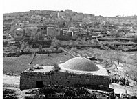 Innaba, sebelum 1948 | |
| Etimologi: Jujube[1] | |
| 31°54′08″N 34°56′52″E / 31.90222°N 34.94778°E / 31.90222; 34.94778Koordinat: 31°54′08″N 34°56′52″E / 31.90222°N 34.94778°E / 31.90222; 34.94778 | |
| Grid Palestina | 145/145 |
| Entitas geopolitik | Mandat Palestina |
| Subdistrik | Ramle |
| Tanggal pengosongan | 10 Juli 1948[4] |
| Luas | |
| • Total | 12,857 dunams (12,857 km2 or 4,964 sq mi) |
| Populasi (1945) | |
| • Total | 1,420[2][3] |
| Sebab pengosongan | Serangan militer oleh pasukan Yishuv |
| Wilayah saat ini | Kefar Shemu'el[5] |
Innaba (Arab: عنابة) adalah sebuah desa Palestina di Subdistrik Ramle, Mandat Palestina. Desa tersebut dikosongkan dalam Perang Arab-Israel 1948 pada 10 Juli 1948 oleh Brigade Yiftach dan Kedelapan dari Operasi Dani. Desa tersebut berjarak 7 km dari timur Ramla.
Referensi
- ^ Palmer, 1881, p. 284
- ^ a b Government of Palestine, Department of Statistics. Village Statistics, April, 1945. Quoted in Hadawi, 1970, p. 66
- ^ Government of Palestine, Department of Statistics, 1945, p. 29
- ^ Morris, 2004, p. xix, village #244. Also gives cause of depopulation
- ^ Khalidi, 1992, p. 384
Daftar pustaka
- Barron, J.B., ed. (1923). Palestine: Report and General Abstracts of the Census of 1922. Government of Palestine.
- Conder, C.R.; Kitchener, H.H. (1883). The Survey of Western Palestine: Memoirs of the Topography, Orography, Hydrography, and Archaeology. 3. London: Committee of the Palestine Exploration Fund.
- Dauphin, Claudine (1998). La Palestine byzantine, Peuplement et Populations. BAR International Series 726 (dalam bahasa French). III : Catalogue. Oxford: Archeopress. ISBN 0-860549-05-4. Pemeliharaan CS1: Bahasa yang tidak diketahui (link)
- Government of Palestine, Department of Statistics (1945). Village Statistics, April, 1945.
- Guérin, V. (1868). Description Géographique Historique et Archéologique de la Palestine (dalam bahasa French). 1: Judee, pt. 1. Paris: L'Imprimerie Nationale. Pemeliharaan CS1: Bahasa yang tidak diketahui (link)
- Hadawi, S. (1970). Village Statistics of 1945: A Classification of Land and Area ownership in Palestine. Palestine Liberation Organization Research Center.
- Hartmann, M. (1883). "Die Ortschaftenliste des Liwa Jerusalem in dem türkischen Staatskalender für Syrien auf das Jahr 1288 der Flucht (1871)". Zeitschrift des Deutschen Palästina-Vereins. 6: 102–149.
- Hütteroth, Wolf-Dieter; Abdulfattah, Kamal (1977). Historical Geography of Palestine, Transjordan and Southern Syria in the Late 16th Century. Erlanger Geographische Arbeiten, Sonderband 5. Erlangen, Germany: Vorstand der Fränkischen Geographischen Gesellschaft. ISBN 3-920405-41-2.
- Khalidi, W. (1992). All That Remains: The Palestinian Villages Occupied and Depopulated by Israel in 1948. Washington D.C.: Institute for Palestine Studies. ISBN 0-88728-224-5.
- Mills, E., ed. (1932). Census of Palestine 1931. Population of Villages, Towns and Administrative Areas. Jerusalem: Government of Palestine.
- Morris, B. (2004). The Birth of the Palestinian Refugee Problem Revisited. Cambridge University Press. ISBN 978-0-521-00967-6.
- Mukaddasi (1886). Description of Syria, including Palestine. London: Palestine Pilgrims' Text Society.
- Palmer, E.H. (1881). The Survey of Western Palestine: Arabic and English Name Lists Collected During the Survey by Lieutenants Conder and Kitchener, R. E. Transliterated and Explained by E.H. Palmer. Committee of the Palestine Exploration Fund.
- Robinson, E.; Smith, E. (1841). Biblical Researches in Palestine, Mount Sinai and Arabia Petraea: A Journal of Travels in the year 1838. 3. Boston: Crocker & Brewster.
- Socin, A. (1879). "Alphabetisches Verzeichniss von Ortschaften des Paschalik Jerusalem". Zeitschrift des Deutschen Palästina-Vereins. 2: 135–163.
Pranala luar
- Welcome To 'Innaba
- Innaba, Zochrot
- Survey of Western Palestine, Map 17: IAA, Wikimedia commons
- 'Innaba from the Khalil Sakakini Cultural Center


