Richmondshire

Questa voce o sezione sull'argomento autorità unitarie dell'Inghilterra non cita le fonti necessarie o quelle presenti sono insufficienti.
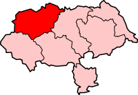
| Distretto del Richmondshire Distretto | |
|---|---|
 | |
| Localizzazione | |
| Stato |  Regno Unito Regno Unito Inghilterra Inghilterra |
| Regione | Yorkshire e Humber |
| Contea |  North Yorkshire North Yorkshire |
| Amministrazione | |
| Capoluogo | Richmond |
| Territorio | |
| Coordinate del capoluogo | 54°24′N 1°44′W / 54.4°N 1.733333°W54.4; -1.733333 (Distretto del Richmondshire) Coordinate: 54°24′N 1°44′W / 54.4°N 1.733333°W54.4; -1.733333 (Distretto del Richmondshire) |
| Superficie | 1 318,67 km² |
| Abitanti | 53 730 (2019) |
| Densità | 40,75 ab./km² |
| Altre informazioni | |
| Fuso orario | UTC+0 |
| Codice ONS | 36UE |
| Rappresentanza parlamentare | Collegio di Richmond (Yorks) |
| Cartografia | |
  Richmond | |
 | |
| Sito istituzionale | |
| Modifica dati su Wikidata · Manuale | |
Il Richmondshire è un distretto del North Yorkshire, Inghilterra, Regno Unito, con sede a Richmond.
Il distretto fu creato con il Local Government Act 1972, il 1º aprile 1974 dalla fusione del borough di Richmond con il distretto rurale di Aysgarth, il distretto rurale di Leyburn, il distretto rurale di Reeth, il distretto rurale di Richmond e parte del distretto rurale di Croft.
Parrocchie civili
- Akebar
- Aldbrough
- Appleton East and West
- Arkengarthdale
- Arrathorne
- Aske
- Askrigg
- Aysgarth
- Bainbridge
- Barden
- Barton
- Bellerby
- Bishopdale
- Bolton-on-Swale
- Brompton-on-Swale
- Brough with St. Giles
- Burton-cum-Walden
- Caldbergh with East Scrafton
- Caldwell
- Carlton Highdale
- Carlton Town
- Carperby-cum-Thoresby
- Castle Bolton with East and West Bolton
- Catterick
- Cleasby
- Cliffe
- Colburn
- Constable Burton
- Coverham with Agglethorpe
- Croft-on-Tees
- Dalton
- Dalton-on-Tees
- Downholme
- Easby
- East Hauxwell
- East Layton
- East Witton
- Ellerton Abbey
- Ellerton-on-Swale
- Eppleby
- Eryholme
- Finghall
- Forcett and Carkin
- Garriston
- Gayles
- Gilling with Hartforth and Sedbury
- Grinton
- Harmby
- Hawes
- High Abbotside
- Hipswell
- Hornby (Richmondshire)
- Hudswell
- Hunton
- Hutton Hang
- Kirby Hill (Richmondshire)
- Leyburn
- Low Abbotside
- Manfield
- Marrick
- Marske
- Melbecks
- Melmerby
- Melsonby
- Middleham
- Middleton Tyas
- Moulton
- Muker
- Newbiggin
- New Forest
- Newsham
- Newton-le-Willows
- Newton Morrell
- North Cowton
- Patrick Brompton
- Preston-under-Scar
- Ravensworth
- Redmire
- Reeth, Fremington and Healaugh
- Richmond
- St Martin's
- Scorton
- Scotton (Richmondshire)
- Skeeby
- Spennithorne
- Stainton
- Stanwick St John
- Stapleton
- Thoralby
- Thornton Rust
- Thornton Steward
- Tunstall
- Uckerby
- Walburn
- Wensley
- West Hauxwell
- West Layton
- West Scrafton
- West Witton
- Whashton
Altri progetti
Altri progetti
- Wikimedia Commons
 Wikimedia Commons contiene immagini o altri file su Richmondshire
Collegamenti esterni
- Sito ufficiale, su richmondshire.gov.uk.

- (EN) Richmondshire, su Enciclopedia Britannica, Encyclopædia Britannica, Inc.

V · D · M | |
|---|---|
| Autorità unitarie | Città di York · Redcar and Cleveland · Middlesbrough · Stockton-on-Tees |
| Distretti o borough | Craven · Hambleton · Harrogate · Richmondshire · Ryedale · Scarborough · Selby |
| Città e paesi | Ampleforth · Bedale · Boroughbridge · Brotton · Catterick · Catterick Garrison · Easingwold · Eston · Filey · Grassington · Great Ayton · Guisborough · Harrogate · Hawes · Haxby · Helmsley · High Bentham · Kirkbymoorside · Knaresborough · Leyburn · Loftus · Malton · Marske-by-the-Sea · Masham · Middleham · Middlesbrough · Northallerton · Norton-on-Derwent · Pateley Bridge · Pickering · Redcar · Reeth · Richmond · Ripon · Robin Hood's Bay · Saltburn-by-the-Sea · Scarborough · Selby · Settle · Skelton-in-Cleveland · Skipton · South Bank · Stokesley · Tadcaster · Thirsk · Thornaby-on-Tees · Whitby · Yarm · York |
| Parrocchie civili del North Yorkshire | |
| Controllo di autorità | VIAF (EN) 309636563 · WorldCat Identities (EN) viaf-309636563 |
|---|


