Basingstoke and Deane
Niet-metropolitaans district in Engeland  | |||
|---|---|---|---|
 | |||
| Situering | |||
| Land | Engeland | ||
| County | Hampshire | ||
| Regio | South East England | ||
| Coördinaten | 51°15'22"NB, 1°6'40"WL | ||
| Algemeen | |||
| Oppervlakte | 633,8173[1] km² | ||
| Inwoners (2018[2]) | 175729 (277 inw./km²) | ||
| ONS-code | E07000084 | ||
| |||

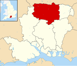
Basingstoke and Deane is een Engels district in het shire-graafschap (non-metropolitan county OF county) Hampshire en telt 176.000 inwoners. De oppervlakte bedraagt 634 km². De hoofdstad en enige stad is Basingstoke. De naam Deane komt van een buurtschap in het district.
Van de bevolking is 12,4% ouder dan 65 jaar. De werkloosheid bedraagt 2,0% van de beroepsbevolking (cijfers volkstelling 2001).
Plaatsen in district Basingstoke and Deane
Basingstoke.
Civil parishes in district Basingstoke and Deane
Ashford Hill with Headley, Ashmansworth, Baughurst, Bradley, Bramley, Burghclere, Candovers, Chineham, Cliddesden, Deane, Dummer, East Woodhay, Ecchinswell, Sydmonton and Bishops Green, Ellisfield, Farleigh Wallop, Hannington, Hartley Wespall, Herriard, Highclere, Hurstbourne Priors, Kingsclere, Laverstoke, Litchfield and Woodcott, Mapledurwell and Up Nately, Monk Sherborne, Mortimer West End, Newnham, Newtown, North Waltham, Nutley, Oakley, Old Basing and Lychpit, Overton, Pamber, Popham, Preston Candover, Rooksdown, Sherborne St John, Sherfield on Loddon, Silchester, St. Mary Bourne, Steventon, Stratfield Saye, Stratfield Turgis, Tadley, Tunworth, Upton Grey, Weston Corbett, Weston Patrick, Whitchurch, Winslade, Wootton St. Lawrence.
Partnersteden
 Eigenbrakel (België)

Bronnen, noten en/of referenties
|


