Ryedale
Niet-metropolitaans district in Engeland  | |||
|---|---|---|---|
  | |||
| Situering | |||
| Land | Engeland | ||
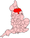
| County | North Yorkshire | ||
| Regio | Yorkshire and the Humber | ||
| Coördinaten | 54°8'20"NB, 0°47'24"WL | ||
| Algemeen | |||
| Oppervlakte | 1506,5937[1] km² | ||
| Inwoners (2018[2]) | 54.920 (36 inw./km²) | ||
| Hoofdplaats ONS-code | Malton E07000167 | ||
| |||

Ryedale is een Engels district in het shire-graafschap (non-metropolitan county OF county) North Yorkshire en telt 50.872 inwoners. De oppervlakte bedraagt 1507 km².
Van de bevolking is 20,4% ouder dan 65 jaar. De werkloosheid bedraagt 2,1% van de beroepsbevolking (cijfers volkstelling 2001).
Civil parishes in district Ryedale
Acklam, Aislaby, Allerston, Amotherby, Ampleforth, Appleton-le-Moors, Appleton-le-Street with Easthorpe, Barton-le-Street, Barton-le-Willows, Barugh (Great and Little), Beadlam, Birdsall, Bransdale, Brawby, Broughton, Bulmer, Burythorpe, Buttercrambe with Bossall, Byland with Wass, Cawton, Claxton, Cold Kirby, Coneysthorpe, Coulton, Crambe, Cropton, Ebberston and Yedingham, Edstone, Fadmoor, Farndale East, Farndale West, Flaxton, Foston, Foxholes, Fryton, Ganton, Gate Helmsley, Gillamoor, Gilling East, Grimstone, Habton, Harome, Hartoft, Harton, Hawnby, Helmsley, Henderskelfe, Heslerton, Hovingham, Howsham, Hutton-le-Hole, Huttons Ambo, Kirby Grindalythe, Kirby Misperton, Kirkbymoorside, Langton, Lastingham, Leavening, Levisham, Lillings Ambo, Lockton, Luttons, Malton, Marishes, Marton, Middleton, Nawton, Newton-on-Rawcliffe, Normanby, Norton-on-Derwent, Nunnington, Old Byland and Scawton, Oldstead, Oswaldkirk, Pickering, Pockley, Rievaulx, Rillington, Rosedale East Side, Rosedale West Side, Salton, Sand Hutton, Scackleton, Scagglethorpe, Scampston, Scrayingham, Settrington, Sherburn, Sheriff Hutton, Sinnington, Slingsby, South Holme, Spaunton, Sproxton, Stape, Stonegrave, Swinton, Terrington, Thixendale, Thornton-le-Clay, Thornton-le-Dale, Thorpe Bassett, Upper Helmsley, Warthill, Weaverthorpe, Welburn (Amotherby Ward), Welburn (Kirkbymoorside Ward), Westow, Wharram, Whitwell-on-the-Hill, Willerby, Wilton, Wintringham, Wombleton, Wrelton.
Bronnen, noten en/of referenties
|


