Woking (district)
Niet-metropolitaans district in Engeland  | |||
|---|---|---|---|
  | |||
| Situering | |||
| Land | Engeland | ||
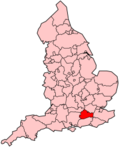
| County | Surrey | ||
| Regio | South East England | ||
| Coördinaten | 51°19'0"NB, 0°33'33"WL | ||
| Algemeen | |||
| Oppervlakte | 63,6034[1] km² | ||
| Inwoners (2018[2]) | 101.167 (1591 inw./km²) | ||
| ONS-code | E07000217 | ||
| Detailkaart | |||
 | |||
| |||

Woking is een Engels district in het shire-graafschap (non-metropolitan county OF county) Surrey en telt 101.000 inwoners. De oppervlakte bedraagt 64 km². Hoofdplaats is Woking.
Van de bevolking is 14,6% ouder dan 65 jaar. De werkloosheid bedraagt 1,8% van de beroepsbevolking (cijfers volkstelling 2001).
Plaatsen
- Woking (62.796 inw.)
- Brookwood (Surrey) (1.442 inw.)
- Byfleet (6.995 inw.)
- Knaphill (10.062 inw.)
- Mayford (1.776 inw.)
- West Byfleet (5.054 inw.)
Bronnen, noten en/of referenties
|


