Bagh-e Malek County
County in Khuzestan province, Iran
County in Khuzestan, Iran
Bagh-e Malek County Persian: شهرستان باغ ملک | |
|---|---|
County | |
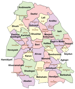 Location of Bagh-e Malek County in Khuzestan province (center right, purple) | |
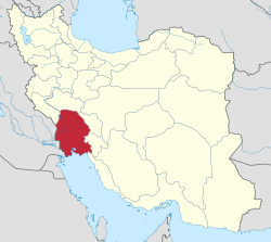 Location of Khuzestan province in Iran | |
| Coordinates: 31°30′51″N 49°47′48″E / 31.51417°N 49.79667°E / 31.51417; 49.79667[1] | |
| Country |  Iran Iran |
| Province | Khuzestan |
| Capital | Bagh-e Malek |
| Districts | Central, Meydavud, Qaleh Tall |
| Population (2016)[2] | |
| • Total | 105,384 |
| Time zone | UTC+3:30 (IRST) |
| Bagh-e Malek County can be found at GEOnet Names Server, at this link, by opening the Advanced Search box, entering "9206384" in the "Unique Feature Id" form, and clicking on "Search Database". | |
Bagh-e Malek County (Persian: شهرستان باغ ملک) is in Khuzestan province, Iran. Its capital is the city of Bagh-e Malek.[3]
Demographics
Population
At the time of the 2006 National Census, the county's population was 103,217 in 19,814 households.[4] The following census in 2011 counted 107,450 people in 23,976 households.[5] At the 2016 census, the county's population was 105,384 in 25,872 households.[2]
In February 2023, Seydun District was separated from the county in the establishment of Seydun County, which was divided into two districts of two rural districts each, with the city of Seydun as its capital and only city.[6]
In April 2023, Qaleh Tall Rural District and the city of Qaleh Tall were separated from the Central District in the establishment of Qaleh Tall District, which was divided into two rural districts, with the city as its capital.[7]
Administrative divisions
Bagh-e Malek County's population history and administrative structure over three consecutive censuses are shown in the following table.
| Administrative Divisions | 2006[4] | 2011[5] | 2016[2] |
|---|---|---|---|
| Central District | 62,217 | 66,700 | 67,827 |
| Haparu RD | 10,888 | 11,495 | 10,941 |
| Mongasht RD | 10,274 | 10,920 | 9,980 |
| Qaleh Tall RD | 8,403 | 8,069 | 7,582 |
| Rud Zard RD | 3,204 | 2,812 | 2,283 |
| Bagh-e Malek (city) | 20,844 | 23,352 | 26,343 |
| Qaleh Tall (city) | 8,604 | 10,052 | 10,698 |
| Meydavud District | 18,588 | 17,725 | 15,302 |
| Meydavud RD | 8,768 | 4,493 | 3,730 |
| Saroleh RD | 9,820 | 9,642 | 8,059 |
| Meydavud (city) | 3,590 | 3,513 | |
| Qaleh Tall District[a] | |||
| Barangerd RD[a] | |||
| Qaleh Tall RD | |||
| Qaleh Tall (city) | |||
| Seydun District[b] | 22,412 | 22,965 | 22,246 |
| Seydun-e Jonubi RD | 9,895 | 9,755 | 8,305 |
| Seydun-e Shomali RD | 7,078 | 6,622 | 6,291 |
| Seydun (city) | 5,439 | 6,588 | 7,650 |
| Total | 103,217 | 107,450 | 105,384 |
| RD = Rural District | |||
See also
![]() Media related to Bagh-e Malek County at Wikimedia Commons
Media related to Bagh-e Malek County at Wikimedia Commons
 Iran portal
Notes
- ^ a b Established after the 2016 census[7]
- ^ Transferred to Seydun County after the 2016 census[6]
References
- ^ OpenStreetMap contributors (25 July 2023). "Bagh-e Malek County" (Map). OpenStreetMap. Retrieved 25 July 2023.
- ^ a b c "Census of the Islamic Republic of Iran, 1395 (2016)". AMAR (in Persian). The Statistical Center of Iran. p. 06. Archived from the original (Excel) on 21 October 2020. Retrieved 19 December 2022.
- ^ Habibi, Hassan (24 September 1369). "Creation and establishment of Seydun District within the boundaries of Sidon, Hepro, Sarleh and Bagh-e Malek Counties in Khuzestan province". Lamtakam (in Persian). Ministry of Interior, Council of Ministers. Archived from the original on 26 January 2024. Retrieved 26 January 2024.
- ^ a b "Census of the Islamic Republic of Iran, 1385 (2006)". AMAR (in Persian). The Statistical Center of Iran. p. 06. Archived from the original (Excel) on 20 September 2011. Retrieved 25 September 2022.
- ^ a b "Census of the Islamic Republic of Iran, 1390 (2011)". Syracuse University (in Persian). The Statistical Center of Iran. p. 06. Archived from the original (Excel) on 18 January 2023. Retrieved 19 December 2022.
- ^ a b "Approval letter regarding country divisions of Bagh-e Malek County, Khuzestan province". DOTIC (in Persian). Ministry of Interior, Board of Ministers. 12 February 2023. Archived from the original on 12 February 2023. Retrieved 25 July 2023.
- ^ a b Jahangiri, Ishaq (27 April 1400). "Letter of approval regarding country divisions in Bagh-e Malek County, Khuzestan province". Qavanin (in Persian). Ministry of Interior, Council of Ministers. Archived from the original on 6 April 2023. Retrieved 25 July 2023.
- v
- t
- e
Khuzestan Province, Iran

and cities
- Abadan's museum
- Gundishapur
- Acropole of Shush
- Apadana in Susa
- Arjan castle, Behbahan
- Asak ancient city, Hendijan
- Chagadom tappe fire temple
- Chogha Mish Proto-Elamite site
- Chogha Zanbil
- Dav o Dokhtar castle, Ramhormoz
- Dez Dam
- Eshkaft-e Salman
- Gargar bridge, Shushtar
- Haft Tepe
- Hoor-al-azim lagoon
- Imamzadeh Roudband, Dezful
- Imamzadeh Sabz-e-ghaba, Dezful
- Karkheh Dam
- Khorramshahr mosque, Battle of Khorramshahr
- Kul-e Farah
- lake of Karkheh dam
- Lake of Karun
- Lali bridge
- Meyangaran lagoon
- Rangooni's mosque
- Salasel castle, Shushtar
- Shadegan lagoon
- Shevi waterfall, Dezful
- Shush-Daniel
- Shushtar Historical Hydraulic System
- Shushtar Watermills
- Susa
- Shush Castle
- Taryana
- Tobiron valley, Dezful
- Tomb of Daniel, Shush
- White bridge, Ahvaz
- Ya'qub-i Laith's tomb, Dezful


